
 Portuguese
  Spanish
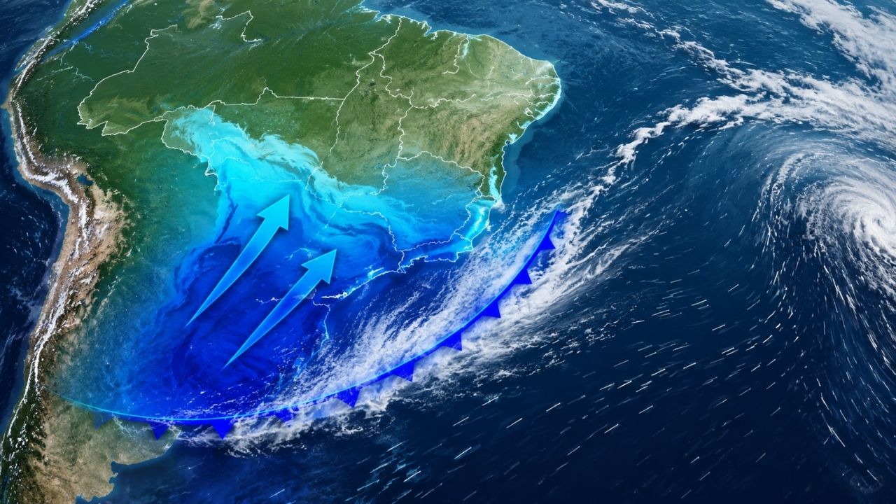
Between Wednesday and Friday, the cold air mass is expected to lower temperatures in the Southeast, with Serra da Mantiqueira near 3°C, moderate rain, accumulations of up to 70 mm, and winds of 60 km/h in São Paulo, Rio de Janeiro, South of Espírito Santo, and South of Minas Gerais under alert.
The cold air mass that was over the South of Brazil at the beginning of the week is expected to move to the Southeast between this Wednesday (20) and Friday (22), with a drop in temperature, Serra da Mantiqueira near 3°C, moderate rain and winds of 60 km/h.
The cold does not come alone. According to the portal nd+, besides the drop in temperatures, there is a forecast of moderate rain showers, winds of up to 60 km/h, and accumulations that can reach 70 mm in some regions, increasing the risk of disruptions in urban areas.
Cold leaves the South and reaches part of the Southeast
After Santa Catarina and Rio Grande do Sul recorded lows close to 0°C between Monday (18) and Tuesday (19), the system begins to influence other areas of the country. Starting this Wednesday, the temperature drop should be felt first in São Paulo.
-
World’s Largest Particle Accelerator Begins Four-Year Hiatus for Magnet Overhaul, Aiming to Hunt Dark Matter by 2030

-
“Sahara Dust Turns Rain Red, Startling Residents Across Europe”
-
Stanford Scientists Develop 20-Cent Paper Centrifuge Inspired by Ancient Toy, Spins at 125,000 RPM Without Electricity, Separates Plasma in 1.5 Minutes, Aiding Diagnostics in Remote Areas

-
World’s Largest Vaccine Manufacturer, Immunizing Two-Thirds of Global Infants, Originated in a Pune Horse Farm


Subsequently, the cold air mass should also reach Rio de Janeiro, the South of Espírito Santo, and the South of Minas Gerais. The change will be more noticeable in the early morning, when the lows tend to be lower.
According to the forecast mentioned by the source, the minimum temperatures should be around 15°C in various affected areas. However, in Serra da Mantiqueira, the cold can be much more intense, with municipalities recording marks close to 3°C.
This scenario reinforces the difference between more moderate urban cold and altitude cold. In mountainous regions, the combination of cold air, high terrain, and insufficient early morning heating can significantly lower the thermometers.
Serra da Mantiqueira may have a low near 3°C

The Serra da Mantiqueira is expected to have the lowest temperatures forecasted for the period. Municipalities located in this area between São Paulo, Minas Gerais, and Rio de Janeiro may wake up with a stronger cold sensation.
The mark of 3°C draws attention because it approaches typical refrigerator temperatures, especially for areas in the Southeast that were not under such intense cold in previous days. Even so, the forecast does not indicate snow; the highlight is the sharp drop in temperature.
The cold air mass is expected to act mainly during the early morning and first hours of the morning. During the day, the sensation may vary according to cloudiness, wind, rain, and altitude of each locality.
For residents and tourists in mountainous areas, greater care should be taken with appropriate clothing, travel in the early hours of the day, and prolonged exposure to the cold, especially for children, the elderly, and people more sensitive to sudden temperature changes.
Moderate rain also puts states on alert
In addition to the cold, the forecast indicates moderate rain in areas of the Southeast. According to the National Institute of Meteorology, São Paulo, Rio de Janeiro, southern Espírito Santo, and much of Minas Gerais may register a risk of rain of up to 50 mm per day.
Meteored indicates that the precipitation should form mainly during the afternoon and evening. This pattern may surprise those expecting only a drop in temperature, as the weather may also become unstable in urban and coastal areas.
The trend is for the showers to start losing strength throughout Thursday (21). Even so, the total accumulations may reach 70 mm in specific points by the end of the period.
The regions with the most attention include the coast of São Paulo, the coast of Espírito Santo, southern Minas Gerais, and the entire state of Rio de Janeiro, according to the forecast cited in the source.
Winds of up to 60 km/h increase the risk of disruptions

The presence of the cold air mass associated with instability may also favor stronger winds. The forecast indicates gusts of up to 60 km/h in the coming days in areas under alert.
This type of wind can cause occasional disruptions, especially when it occurs along with moderate rain. Branches, signs, light structures, and power grids become more vulnerable in episodes of gusts.
The most direct risk to the population is flooding and power outages, especially in urban areas with limited drainage or regions that already face water accumulation easily.
Therefore, drivers should be extra cautious on flood-prone roads, sections with low visibility, and areas prone to falling branches. In case of a storm, the recommendation is to avoid sheltering under trees and keep a distance from unstable structures.
Four states should feel a change in the weather
São Paulo is expected to be one of the first states impacted by the drop in temperature. The change will begin to be felt starting this Wednesday, with a gradual influence of cold air and increased instability in some regions.
In Rio de Janeiro, the forecast involves both a drop in temperatures and accumulated rain over the period. The state is among the areas where total accumulations can reach 70 mm, requiring attention in urban centers.
In the south of Espírito Santo, the highlight is the combination of rain, wind, and a drop in temperature. In Minas Gerais, the main attention is focused on the south of the state, especially due to the influence of the Serra da Mantiqueira.
The cold air mass is not expected to affect all locations with the same intensity. The effect varies according to altitude, proximity to the coast, cloudiness, and the advance of instability areas.
Cold, rain, and wind require attention until Friday
The most important period of the forecast is from this Wednesday (20th) until Friday (22nd). During these days, residents of the affected areas should follow weather updates, as rain and wind can quickly change in intensity.
In higher altitude locations, the cold may be the main highlight. In urban and coastal areas, moderate rain and winds may weigh more on the routine, especially during commuting hours.
The scenario does not indicate a widespread extreme event, but it requires attention due to the combination of factors. Low temperatures, rain showers, wind gusts, and significant accumulations can cause localized impacts.
For those living in areas vulnerable to flooding, the guidance is to observe official alerts and avoid crossing streets taken by water. For those hitting the road, it is worth checking the weather conditions before leaving.
Southeast enters a period of instability after cold in the South
The arrival of the cold air mass in the Southeast shows how systems that first act in the South can advance and reorganize the weather in other regions of the country. In a few days, the cold moved from lows close to 0°C in Santa Catarina and Rio Grande do Sul to influence areas of four states.
The main point of the forecast is the combination of cold air and instability. The temperature drops, but the weather can also bring rain and wind, creating a more complex scenario than just a change in the thermometers.
For the Serra da Mantiqueira, the highlight is the lows near 3°C. For urban areas, the greater alert involves moderate rain, risk of flooding, and the possibility of power outages.
And you, do you prefer cold days like those the cold air mass is expected to bring to the Southeast, or do you think the combination of rain, wind, and a sharp temperature drop disrupts your routine too much? Share your opinion.


