
 Portuguese
  Spanish
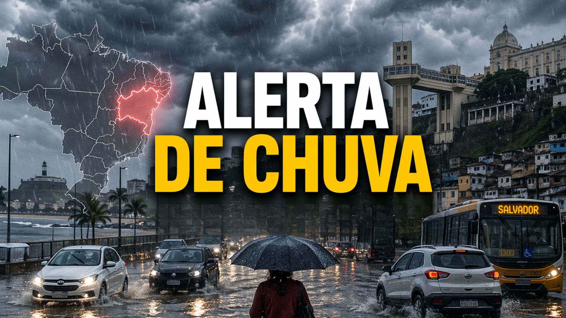
Persistent rains increase risk in Salvador, RMS, and the Baiano coast with soil already saturated and rivers high, a scenario that amplifies urban impacts and requires redoubled attention for vulnerable areas over the next 24 hours.
Salvador, the Metropolitan Region, the Recôncavo, and the North Coast of Bahia remain under a meteorological alert for 24 hours following a warning issued by the Institute of Environment and Water Resources, Inema, on Wednesday, April 22.
According to the agency, the continuation of rains associated with atmospheric instabilities keeps the risk of flooding, river overflows, and landslides high in stretches of the Baiano coast that have already been recording significant accumulations.
Most affected areas and immediate risk
The announcement focuses attention on urban areas and points of more vulnerable relief, especially where the terrain shows signs of saturation after several days of precipitation.
-
$7,999 Isaac 1 Robot Aims to Tackle Household Chaos: Folds Clothes, Makes Beds, and Organizes, but Raises Privacy and Cost Concerns with Camera Reliance and Remote Human Assistance

-
Mobile Electron Accelerator Units Enable Safe Testing of Water, Materials, and Industrial Waste Treatment in Countries Without Permanent Labs

-
Brazil Invests $12 Million in Biodiversity to Develop Drug Molecules, but When Will It Reduce Dependence on Imported Pharmaceutical Ingredients?
-
3D Printing: From 1945 Sci-Fi Concept to Modern-Day Prosthetics, Homes, and Industrial Parts


In these locations, the territory’s response tends to be quicker and more severe because the volume already absorbed by the soil reduces the capacity for natural drainage and increases pressure on slopes, urban channels, and smaller rivers.
According to Inema, the rain should not only be observed by the volume expected for the next few hours but by the set of factors that act simultaneously on the coastal strip.
The persistence of cloud cover, the frequency of precipitation, and the occurrence of gusts of wind create a scenario of greater instability, with the possibility of more intense episodes at certain times of the day and direct reflections on urban mobility and safety in exposed areas.
What explains the intensity of the rains
The meteorologist Cláudia Valéria from Inema stated that the combination of persistent cloud cover, frequent rains, and winds intensifies the effects of bad weather, especially in regions where the soil is already saturated.
According to her, this context increases the risk of occurrences such as flooding, river overflows, and landslides, with a greater impact on urban areas and in places with a history of geotechnical instability.
The capital of Bahia appears among the points of greatest attention because it has a high population density, intense vehicle circulation, and neighborhoods historically sensitive to disruptions during prolonged periods of rain.
In Salvador, the overload of the drainage system and the presence of settlements on slopes make the advance of water more problematic when precipitation extends over several days, even without an extreme peak concentrated in a short interval.
Impacts in the Metropolitan Region and interior
The same risk pattern reaches municipalities of the RMS, as well as sections of the Recôncavo and the North Coast.
In these areas, the combination of urbanization, maritime influence, and limited drainage favors rapid impacts on streets, properties, and circulation corridors, especially when there is continuity of rainfall and maintenance of high humidity along the coast.
The forecast from the institute itself indicates a sky from cloudy to partially cloudy, with rain throughout the period and moderate winds over the eastern strip.
Another point that weighs in the technical assessment of the agency is the rise in river levels in the 48 hours prior to the issuance of the warning.
When watercourses are already responding to recent accumulations, new downpours begin to encounter a more pressured system, which increases the likelihood of overflow in susceptible areas and worsens the situation in regions crossed by streams, channels, and urban rivers with lower drainage capacity.
Saturated soil increases the risk of landslides
This scenario also helps explain why the alert is not limited to the chance of heavy rain at a single moment.
The core of the concern lies in the persistence of an environment conducive to ongoing instabilities, a condition that sustains water accumulation and prolongs the effects of the event on slopes, urban roads, and more vulnerable residential areas.
In such contexts, successive downpours, even if interspersed with periods of lower intensity, can keep the risk elevated for longer.
The condition of the soil appears as one of the central elements of this monitoring.
With the ground already saturated, rainwater finds lower infiltration capacity and tends to run off more quickly over the surface, forming puddles on roads and increasing the instability of slopes and embankments.
The problem becomes more sensitive in densely populated areas, where urban infrastructure does not always keep pace with the speed at which the accumulated rainfall builds up.
Monitoring and forecasting continue
Although the alert has an initial validity of 24 hours, Inema has been indicating the maintenance of rain along the coast, including Salvador, RMS, and Recôncavo, also in the forecast trend for the following days.
This indication does not, by itself, mean an automatic repetition of the same level of severity, but reinforces the need for continuous monitoring of the scenario, as the persistence of the rainy pattern directly interferes with the response of rivers, slopes, and drainage systems.
Since mid-April, the institute has been drawing attention to the persistence of instabilities in the Recôncavo and coastal areas of Bahia, associating the risk with high humidity and saturated soil.
The new warning expands this picture by highlighting Salvador, the Metropolitan Region, and the North Coast among the areas with the highest concentration of rain, at a time when the accumulations of recent days are already producing concrete effects on the urban and hydrological dynamics of these regions.
The monitoring is the responsibility of the Inema Situation Room, which gathers meteorological and hydrological data to guide preventive measures and support the actions of authorities.
In prolonged episodes of instability, this monitoring becomes crucial as it allows for an updated understanding of weather behavior and technically measures how the territory responds to the sequence of precipitation.
In areas already affected by persistent rain, the decisive element now is less the isolated occurrence of a heavy downpour and more the combination of saturated soil, elevated rivers, pressured drainage, and the maintenance of atmospheric instabilities along the Bahian coast.


