Portuguese
  Spanish
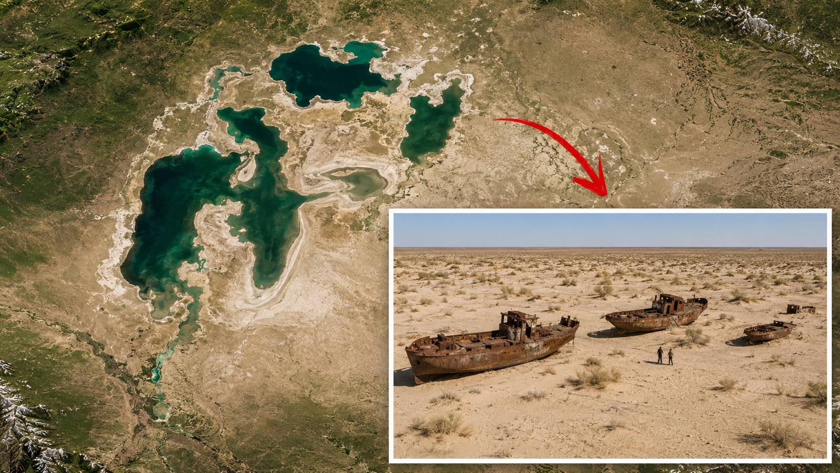
Aral Sea lost 90% of its volume after diversions for Soviet irrigation, turned into a desert, and left one of the greatest environmental tragedies of the modern era.
The Aral Sea was once the fourth largest inland water body in the world, with about 68,000 km² in 1960, between present-day Kazakhstan and Uzbekistan. From that decade, however, the Soviet Union began diverting the waters of the Amu Darya and Syr Darya rivers to expand irrigated agriculture in Central Asia, especially in areas related to cotton production. The result was an environmental collapse of historical scale. According to NASA, the lake lost 90% of its volume since 1960 and ended up fragmented into smaller portions; according to the agency itself, in 2014 the eastern lobe of the South Aral Sea disappeared completely.
What was once a vast mirror of water turned into exposed soil, saline dust, a health crisis, and economic collapse for cities dependent on fishing.
Diversion of the Amu Darya and Syr Darya rivers doomed the Aral Sea to shrinkage
Britannica points out that the main cause of the Aral Sea shrinkage was the diversion, for irrigation purposes, of the waters of the Syr Darya to the north and the Amu Darya to the south, which historically supplied the lake. The encyclopedia records that, with the conversion of large areas of Central Asia into irrigated farms during the Soviet period, the amount of water reaching the Aral plummeted drastically.
-
A nurse bought for 20,000 a 1955 house abandoned by a hoarder in Texas, and months later, rain revealed a buried pool in the backyard valued at $160,000, which he restored himself for about $10,000, a fraction of the cost of building a new one.

-
The United Kingdom is transforming dog feces left on trails into gas to light a streetlamp through an unlikely and surprising project that shows how even one of the most rejected wastes in cities can generate energy.
-
Goodbye traditional Air Fryer: Philips surprises with a version featuring two baskets, steam cooking, self-cleaning, 9-liter capacity, recipe synchronization, and technology that makes food crispy on the outside and soft on the inside.
-
Russia has built a colossal radio telescope nearly 600 meters in size, composed of 895 metal panels in a gigantic ring, which uses the Earth’s rotation to capture invisible signals coming from the Sun and the most distant regions of the universe.


This process was not a natural fluctuation common in endorheic lakes, but a large-scale planned intervention.
Still according to Britannica, by the 1980s the two major rivers were practically dry during the summer before reaching the lake, and evaporation began to far exceed water replenishment.
The tragedy became even more apparent in satellite images. NASA recorded that since 1960, the Aral lost 90% of its volume, fragmented into several bodies of water, and entered a spiral of shrinkage that more severely affected the southern part. In 2024, the agency also observed that the lake had receded to about 10% of its original area, a sign of the depth of the devastation.
Collapse of the Aral Sea destroyed fishing and spread toxic dust over the region
As the lake dried up, the crisis ceased to be merely hydrological and began to affect the entire life structure of the region. NASA reports that the fisheries and communities that depended on them collapsed, while the remaining water became saltier and contaminated by fertilizers and pesticides carried by irrigated agriculture. The same source reports that the exposed bed of the former lake began to release dust mixed with salts and agricultural residues into the atmosphere, becoming a public health risk.
The loss of that enormous body of water also altered the regional climate: winters became colder and summers hotter and drier, increasing the impact on agriculture and daily life in Central Asia.
In 2024, NASA described the Aralkum as one of the world’s newest deserts, formed over the former bed of the Aral Sea and covering about 62,000 km². The agency also highlighted that the rapid aridification began to generate sand and dust storms that affect air quality, consolidating a new landscape where there was once water.
Muynak became a visible symbol of the catastrophe that pushed the sea away from the coast
The devastation of the Aral Sea can be clearly seen in former port cities. In its entry on the environmental consequences of the lake, Britannica states that the ports of Aral, in the northeast, and Mŭynoq, in the south, became distant from the shore as the water receded, leading to partial depopulation of areas once directly connected to fishing.
The same source records that the rapid retreat of the lake virtually destroyed the region’s fishing industry. Salinity increased, fish disappeared en masse, and the economy built around fishing lost its foundation, leaving boats, port structures, and entire neighborhoods without economic function.
For this reason, Muynak became one of the most well-known portraits of this environmental tragedy. What was once a city connected to water now faces a dry horizon, marked by abandoned ships, saline dust, and a geography radically altered by the decision to use the rivers that fed the lake to support irrigated agriculture.
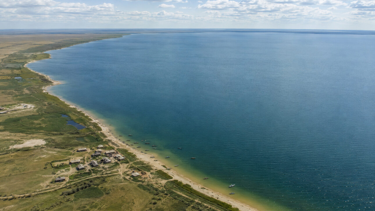
Kok-Aral Dam showed that part of the Aral Sea can still recover
Despite the scale of the disaster, the north of the lake showed a rare sign of recovery. NASA reports that Kazakhstan built a dam between the northern and southern parts of the Aral to try to preserve a portion of the lake, and that the Kok-Aral Dam, completed in 2005, helped to contain the outflow of water from the North Aral Sea.

The World Bank, which supported this effort, reports that the gradual restoration of the north helped to reduce some of the most severe environmental and social effects. The institution reported, at the time, that the salinity of the water should drop from about 23 grams per liter to 10 grams per liter, approaching the levels of 1960, while fish species and fishing activities began to reappear in some areas.
This recovery, however, is partial and localized. NASA itself emphasizes that the dam favored the recovery of fishing in the north, but did not prevent the advancement of the crisis in the south, where the retreat continued dramatically.
The Aral Sea remains a global warning about what happens when water withdrawal for irrigation persistently exceeds the natural replenishment capacity of a large lake.