Portuguese
  Spanish
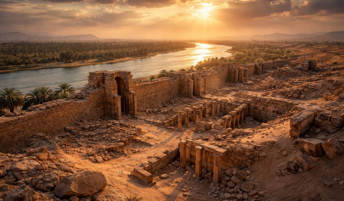
Ruins in Southern Iraq Rekindle Old Debates About Hellenistic Cities, River Trade, and Environmental Changes That Shaped Strategic Ports of Antiquity, After Decades Out of Reach of Systematic Excavations and Conflicts That Interrupted Archaeological Research.
Archaeologists have identified in southern Iraq the ruins of an ancient port city founded at the end of the 4th century BC, during the campaigns of Alexander the Great. The site is historically associated with the name Alexandria on the Tigris and remained for centuries outside the focus of systematic archaeological research.
With the resumption of studies, the site has returned to the center of academic debate for its role in the networks of goods circulation that connected the rivers of Mesopotamia to the maritime routes of the Persian Gulf. The analysis of the structures suggests a planned occupation integrated into long-distance trade flows.
The ruins were located at Jebel Khayyaber, in the southernmost part of Iraq, near the border with Iran. The region combines natural and historical characteristics that, throughout the 20th century, hindered the realization of continuous and systematic excavations.
-
Brazilian Man Ingeniously Transforms Air Fryer into Functional Speaker with Radio and Volume Controls

-
Rows of “stone balls” emerge at low tide on California beach, with formations up to 1.5 meters aligned like a Pacific bowling alley

-
Japan Installs 800 Cameras in Tohoku Mountains Amid Rising Bear Attacks

-
Workers Installing Fiber Optics in French Town Discover 75 WWII-Era Concrete Training Bombs, Each Weighing 250 Kilograms


Recent research indicates the existence of a planned urban center, with well-defined defensive systems and traces of infrastructure associated with port and transport activities. These elements reinforce the interpretation that the site had a strategic function in antiquity.
Archaeological Ruins at Jebel Khayyaber
Today, Jebel Khayyaber presents itself as a discreet elevation amidst the plain. However, archaeological surveys show that the relief conceals large-scale constructed structures, incompatible with natural formations.

Work resumed in 2014 identified that part of this elevation corresponds to a wall over a kilometer long, preserved in some sections at several meters high. The size of the defensive system points to a considerable urban settlement.
According to the researchers involved, the combination of extensive walls and internal spatial organization indicates prior planning, a recurring characteristic in cities founded or reorganized during the Hellenistic period.
Port City and Ancient Trade Routes
The location attributed to Alexandria on the Tigris helps to explain its strategic importance in antiquity, according to archaeological and historical analyses. The site would be positioned in an area that allowed integration between inland Mesopotamian river routes and paths leading to the Persian Gulf.
This positioning would have facilitated the flow of products and the circulation of people, a central element for port-oriented cities. Experts emphasize that this type of articulation was fundamental for the functioning of the commercial networks of the period.
These networks depended on intermediary points capable of concentrating, redistributing, and directing goods. In this context, the city would have operated as a regional trading post, connecting areas of Central Asia and the Indian subcontinent, as indicated by comparative studies on Hellenistic trade.
Charax Spasinou and the Historical Debate
The identification of the ruins at Jebel Khayyaber also relates to an ancient debate about the location of Charax Spasinou, a city mentioned by classical authors. Part of the literature associates Charax with a major port center in southern Iraq, while other studies indicate different locations along the region’s river courses.

Researchers note that the diversity of names attributed to the settlement over time contributed to the difficulty of accurate identification. Cities founded in the Hellenistic period underwent successive reconstructions and renamings, not always thoroughly recorded in ancient sources.
Still, the material evidence found at Jebel Khayyaber is considered compatible with historical descriptions of a large fortified urban center. The academic debate, however, remains open.
Conflicts and the Interruption of Archaeological Research
Indications of the existence of ancient structures in the area had already been recorded in surveys conducted since the 1960s. However, armed conflicts and political instability interrupted research before systematic excavations could advance.
The resumption only became possible in 2014, when international teams managed to return to the site in cooperation with local authorities. Even so, researchers report that activities remain conditioned to security and logistical issues.
These limitations affect the extent of the areas investigated directly. For this reason, methods of prospecting and mapping have been prioritized over extensive excavations.
Environmental Changes and the Abandonment of the City
Archaeological studies associate the decline of the city with environmental changes that occurred between the 3rd and 4th centuries AD. According to this interpretation, modifications in the course of the rivers would have moved the port away from the main navigable routes.

In delta regions of southern Iraq, variations in the channel layout are documented phenomena and may have a direct impact on cities dependent on navigation. With the loss of adequate access to river routes, port activity would have lost relevance.
This economic weakening would have led to the gradual abandonment of urban occupation, ending a cycle of regional importance built over centuries.
What Ongoing Studies Aim to Clarify
Current research aims to map the city’s extent with greater precision and identify different areas of use, such as residential sectors, productive spaces, and zones associated with the port. To this end, archaeologists use systematic records of surface materials, aerial imagery, and relief analyses.
Another focus is to distinguish the phases of occupation of the site. Researchers seek to separate what can be attributed to the foundation period of Alexander from what corresponds to later reoccupations, common in settlements that underwent different political and economic contexts.