Portuguese
  Spanish


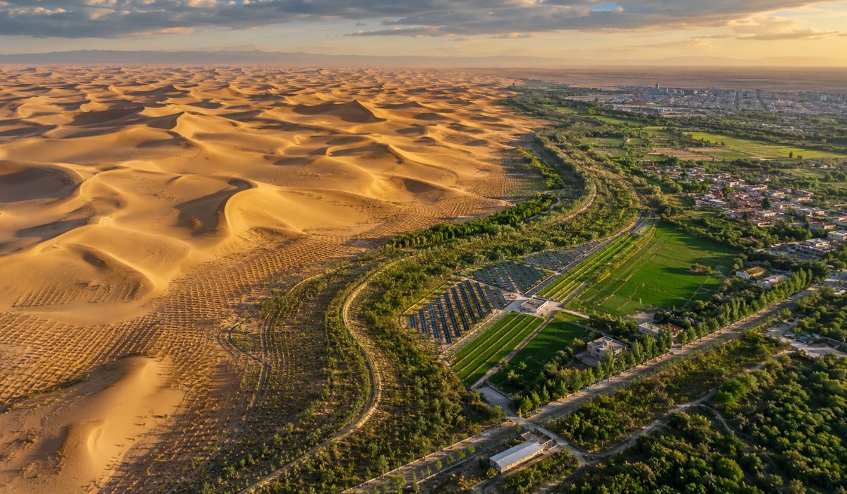


China transformed the edge of the Taklimakan into an environmental containment strip with vegetation, straw, irrigation, and solar energy, in a project that combines engineering, science, and participation of local communities.
China completed a green belt of 3,046 kilometers around the Taklimakan Desert in Xinjiang, in the northwest of the country, to reduce the advance of sand over oases, crops, pastures, roads, and inhabited areas.
The barrier combines drought-resistant trees, straw grids, irrigation, solar energy, and dune stabilization works, according to information released by the state agency Xinhua.
The project was concluded on November 28, 2024, after 46 years of actions associated with the Three-North Shelterbelt program, initiated in 1978 and scheduled to continue until 2050.
-
She spent 73 years breathing inside an iron lung, survived the aftereffects of polio, and became the last woman in the United States dependent on the equipment before dying at 78 years old.

-
Brazilian students created a $1 filter using pine bark, cotton, and 3D-printed parts to clean cassava wastewater, reduce the toxicity of a hazardous waste, and transform contaminated water into biofertilizer.

-
Astronaut from Artemis II steps down after mission to the Moon and decision surprises after a record of 406,771 km, a historic 10-day journey, and an unprecedented achievement for Canada.

-
A fossil kept for years in a small museum in Montreal concealed 450-million-year-old soft tissue, a discovery that has only happened once before in history.


Reuters reported that the campaign is part of China’s effort to curb desertification and sandstorms, but also noted questions about the survival of trees in arid areas and the limits of the measure against storms affecting distant regions.
Taklimakan is the largest desert in China
The Taklimakan is the largest desert in China and one of the largest mobile sand deserts in the world.
According to Xinhua, it occupies about 337,600 km² and has an approximate perimeter of 3,046 km, the length used as a reference for the belt built around its edge.
The mobility of the dunes is one of the central points of the problem.
In parts of Xinjiang, the sand moves with the wind and can reach agricultural areas, canals, highways, and villages.
Therefore, the project treats the desert’s periphery as a containment strip, formed by vegetation, physical barriers, and water infrastructure.
The proposal is not to eliminate the desert, but to reduce the dispersion of sand in areas considered vulnerable by Chinese authorities.
This difference is important because arid regions have their own dynamics of soil, wind, and water, and interventions of this type depend on continuous maintenance and local adaptation.
What is on the edge of the desert
In the most exposed sections, workers use the technique known as “straw chessboard”.
The structure divides the sandy soil into small squares, reduces wind speed near the surface, and helps hold the dunes in place before planting.
After the initial fixation, species adapted to aridity, such as saxaul, red willow, Euphrates poplar, and other plants capable of withstanding heat, salinity, and low water availability are introduced.
The choice of species varies according to the soil, wind, and water conditions of each area.
In Yutian, one of the regions mentioned by Xinhua, the combination of straw grids and terrain modeling was associated with reduced leveling costs and increased vegetation survival rates.
The percentages presented, however, were reported by the Chinese state agency itself and have not been independently confirmed by external sources.
In Shaya, also in Xinjiang, part of the desertification control uses photovoltaic systems to pump brackish groundwater and supply drip irrigation.
According to Song Ye, director of the local forestry and grassland department, the county has installed more than 30 distributed solar pumping systems and converted 63 thousand mu of desert into productive area.
Reuters also recorded the use of solar panels in desertification combat projects in northern and western China.
In this model, the panels generate energy, create shade, and reduce evaporation in the soil, which can favor the growth of shrubs and grasses in dry environments, according to project managers interviewed by the agency.
Engineering and Science in Combating Desertification
The Taklimakan belt was included among the Top 10 Global Engineering Achievements of 2025, a selection linked to the World Federation of Engineering Organizations.
The technical publication described the work as a green ecological barrier around a desert, with a combined use of afforestation, grasslands, mechanical sand fixation, and control supported by photovoltaic energy.
The Chinese Academy of Sciences reported that a 16-day expedition traveled the 3,046 km border to assess the effects and problems of the so-called desert “locking” project.
The survey brought together researchers from Xinjiang institutions and the Institute of Ecology and Geography of the academy itself.
This monitoring is necessary because the effectiveness of a green barrier depends on local factors.
Water availability, salinity, wind direction, soil type, and seedling survival can alter the outcome from one area to another.
In more protected regions, a technique may help stabilize the soil.
In wind corridors or areas with mobile dunes, the same solution may require reinforcement, species replacement, or more frequent maintenance, according to the logic described by researchers and technicians involved in desertification projects.
Rural communities participate in recovery
The project also began to involve communities living near the desert.
In Hotan, residents like Tursunbaq Mahmuthet and Sudiumay Tursun returned to their hometown to participate in restoration and cultivation activities in recovered areas, according to Xinhua.
“When we were young, this whole area was desert,” the two told the Chinese agency, speaking about planting seedlings on lands once covered by sand.
The statement was maintained because it is in the original Xinhua text and is attributed to the interviewees.
The couple joined a cooperative with other families to plant desert date palms in a recovered area.
In Hotan County, cumulative efforts to control desertification reached 61,800 mu and benefited 1,278 families, according to data released by the state agency.
Another frequently cited section by the Chinese government is the Tarim Desert Highway.
The highway, presented as China’s first desert road, has a protection strip of 436 km with more than 20 million drought-tolerant plants, including saxaul and red willow, according to Xinhua.
Economy grows on the edge of the sand
In addition to sand containment, regional authorities associate the green belt with the growth of economic activities in border areas.
In Yutian, rose fields near the G315 highway supply cosmetic and pharmaceutical chains, according to the Chinese agency.
The same county concentrates, according to Xinhua, about 80% of China’s cistanche production, a plant used in traditional Chinese medicine.
The activity was associated by the agency with the creation of more than 10,000 local jobs.
In April 2026, Xinhua reported that the so-called sand-based industries occupied 10.83 million mu, about 722,000 hectares, with an annual production value of 28.975 billion yuan.
Among the activities cited are medicinal plants, fruits, pistachios, roses, ecological tourism, and rural processing chains.
The numbers indicate the economic dimension attributed by the Chinese government to the recovery of the Taklimakan border.
Still, some of the data on income, tourism, jobs, and productivity come from official Chinese sources, without broad independent confirmation from international bases consulted.
Reuters reported that 26.8% of Chinese territory remained classified as desertified, a slight decrease from 27.2% a decade earlier.
The agency also cited criticisms of the strategy, including low tree survival, limited effects on sandstorms, and risks of ecological imbalance when planting projects do not adapt to the local environment.
For researchers and technicians interviewed in reports on the subject, such projects depend on permanent monitoring.
Mohamed Elfleet, a research consultant at King Abdulaziz University in Saudi Arabia, told Xinhua that desertification control experiences can be transferred to other regions, provided they are adjusted to local conditions.
Peter Gilruth, senior advisor of the resource mobilization unit at World Agroforestry, was also quoted by Xinhua as saying that combating desertification goes beyond protecting oases.
“This is a systemic challenge that affects entire continents and the global community,” he told the agency.
In the case of the Taklimakan, the experience combines a physical barrier, resistant species, localized irrigation, solar energy, and the participation of rural communities.
The issue being analyzed by researchers, governments, and international organizations is to what extent this model can be maintained on a continental scale without increasing pressure on water, soil, and biodiversity in already vulnerable regions.