Portuguese
  Spanish
NASA Reveals Shocking Images of Smoke from Fires in Brazil, Visible from Over 1.5 Million Kilometers in Space. The Destruction Caused by Wildfires Is Taking Alarming Proportions.
If you think that only the monumental constructions of humanity, such as the Great Wall of China or the pyramids of Egypt, can be seen from space, get ready for an alarming surprise!
The NASA has just revealed stunning images of smoke from fires in Brazil, visible at a shocking distance of over 1.5 million kilometers from Earth.
For experts, this disturbing view serves as a global alert and highlights the devastating scale of wildfires in Brazilian territory.
-
21-Year-Old Brazilian Student Turns Homemade Popsicle Hobby into $100,000-a-Month Business

-
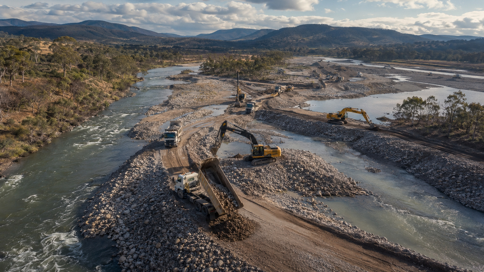
Australia Dumps Hundreds of Thousands of Tons of Gravel into Rivers to Restore Natural Barriers and Reverse 150 Years of Erosion

-
Bird-Inspired Robot Glides on Air Currents up to 10 m/s, Balances Itself, and Aims to Save Energy in Industrial Inspections and Meteorological Balloons
-
Eight Artists Secretly Lived in a Hidden 70m² Apartment Inside a Shopping Mall in Brazil for Four Years


According to information from the website METSUL, NASA satellites captured on September 12 a gigantic cloud of smoke spreading over more than half of Brazil, highlighting the devastating impact of the fires, both on the environment and the population.
These images, obtained by the Deep Space Climate Observatory (DSCOVR) satellite, demonstrate how the fires in Brazil are reaching proportions that even affect the planet’s spatial vision.
According to NASA, the DSCOVR satellite was launched in February 2015 with the mission to monitor space weather, acting as a kind of “sentinel” to predict the arrival of solar storms.
Although the primary goal of the satellite is not to observe Earth, it captured the smoke due to its distant orbit, at 1.5 million kilometers from Earth, at point L1 — an area of gravitational balance between Earth and the Sun.
The Role of the DSCOVR Satellite and Its Critical Functions
In addition to capturing stunning images of Earth, the DSCOVR plays a crucial role for NASA and NOAA (National Oceanic and Atmospheric Administration) by providing accurate forecasts about space weather, especially concerning geomagnetic storms and solar activity. Solar storms can cause massive damage, interfering with satellite communications, GPS systems, power grids, and even aviation systems.
According to NASA, the DSCOVR can provide warning of solar storms between 15 to 60 minutes before they hit Earth, allowing time for governments and companies to take preventive measures. This type of monitoring is vital to avoid failures in global public infrastructure, which could be devastating.
")
Fire Monitoring: The Alert Comes from Space
The smoke from the fires in Brazil draws attention not only for its environmental impacts but also for what it represents in terms of natural disasters and climate change.
The DSCOVR satellite is designed to monitor the Sun, but the gravity of the situation in Brazil has made it possible to see from space the devastation caused by the fires.
This generates an alert not only for Brazilians but also for the entire international community about the consequences of deforestation and burning.
According to experts, the increase in fires is directly related to the expansion of the agricultural frontier and illegal land exploitation, factors accelerating the deforestation of the Amazon.
The impact on biodiversity, climatic balance, and air quality is catastrophic. Furthermore, the effects of the fires intensify climate change, creating a vicious cycle that threatens the very survival of the Brazilian ecosystem.
How Can Spatial Monitoring Help Us Combat Fires?
The advanced technology used by satellites like the DSCOVR not only allows us to see the impact of fires from space but also helps us understand the behavior of the smoke and its global effects.
The combination of data provided by the satellite, along with information collected on the ground, can offer a detailed view of how the fires are spreading and affecting different regions.
This can assist authorities in developing more effective public policies to contain the fires and mitigate their effects.
According to experts from INPE (National Institute for Space Research), it is possible to predict, based on satellite data, the most critical points of the fires and redirect firefighting teams more strategically, saving resources and acting more quickly.
What Does the Future Hold? How Can Brazil Avoid the Worst?
The alert that comes from space is clear: if drastic measures are not taken, the destruction will continue on a global scale.
The fires not only have a local effect but can influence global climate, disrupting the balance of the planet. Public policies that encourage the sustainable use of forests and the protection of environmental areas are crucial to halt this destructive advance.
The question remains: is Brazil prepared to act with the necessary urgency or will we watch helplessly as the Amazon disappears before our eyes? Based on the images coming from space, the answer may be more urgent than we think.