 Portuguese
  English
  Spanish
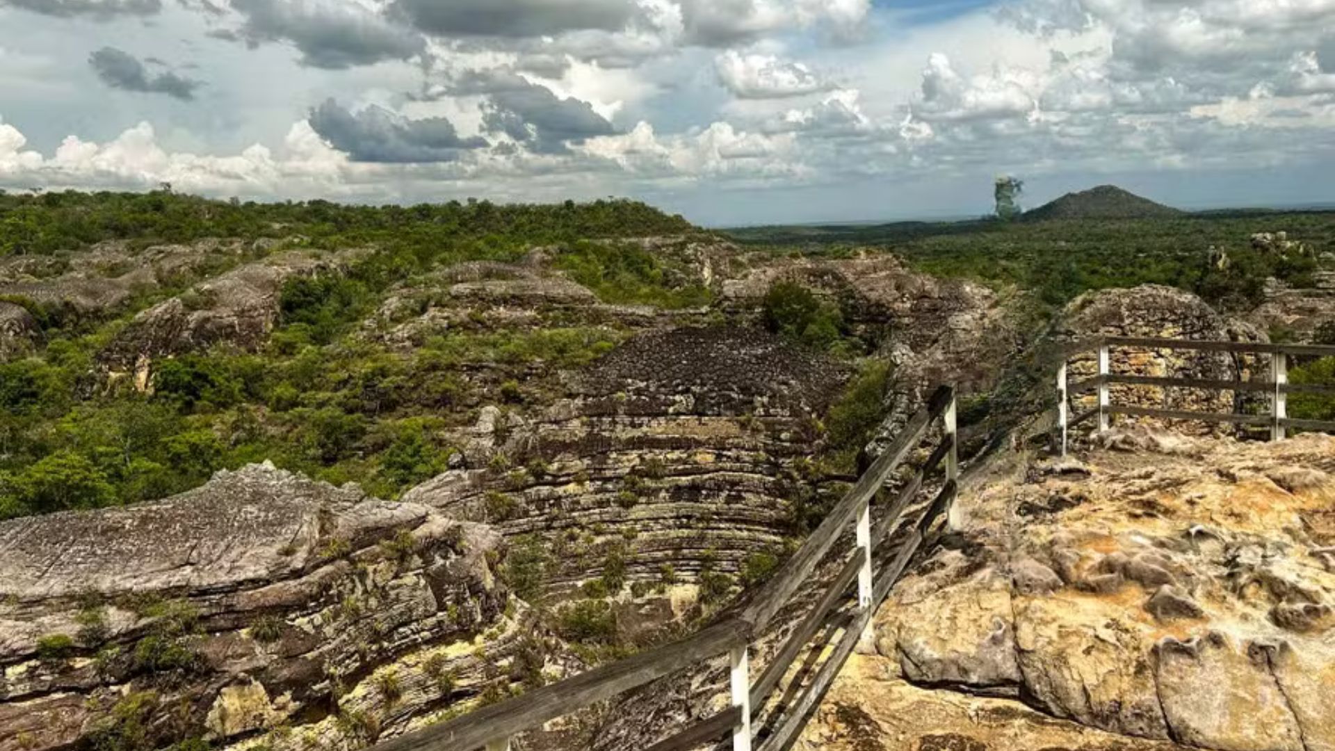


Long-Distance Trek Connects Landscapes of Serra da Ibiapaba, Links Conservation Units and Communities, and Offers a Structured Route with Different Levels of Difficulty.
The new trek Paths of Ibiapaba links Ceará and Piauí in an official route of 180 kilometers, connecting protected areas and communities in the Serra da Ibiapaba and surrounding region, with sections that cross Atlantic Forest, Caatinga, and Cerrado.
Structured as a long-distance trail, the route has been divided into 13 sections with distinct levels of difficulty and can be completed in its entirety, in about seven days, or in segments, with the possibility of alternating between walking and biking at specific points.
Along the way, the route integrates the Ubajara National Park, the Sete Cidades National Park, and the Serra da Ibiapaba Environmental Protection Area, creating a continuous link between conservation units that previously operated in a more isolated manner.
-
Reports about the possible arrest of Diogo Defante in the USA during the 2026 World Cup are making waves on social media and raising questions about what really happened.

-
The 71-year-old Korean pastor who built a box in the wall to save abandoned babies and has already taken in more than 2,000 children without asking for the name of any mother.
-
Mother of four faces financial difficulties in São Paulo, swaps jobs outside the home for sweet and savory pies, and turns the kitchen into a source of income to support the family while studying nursing to change her children’s future.

-
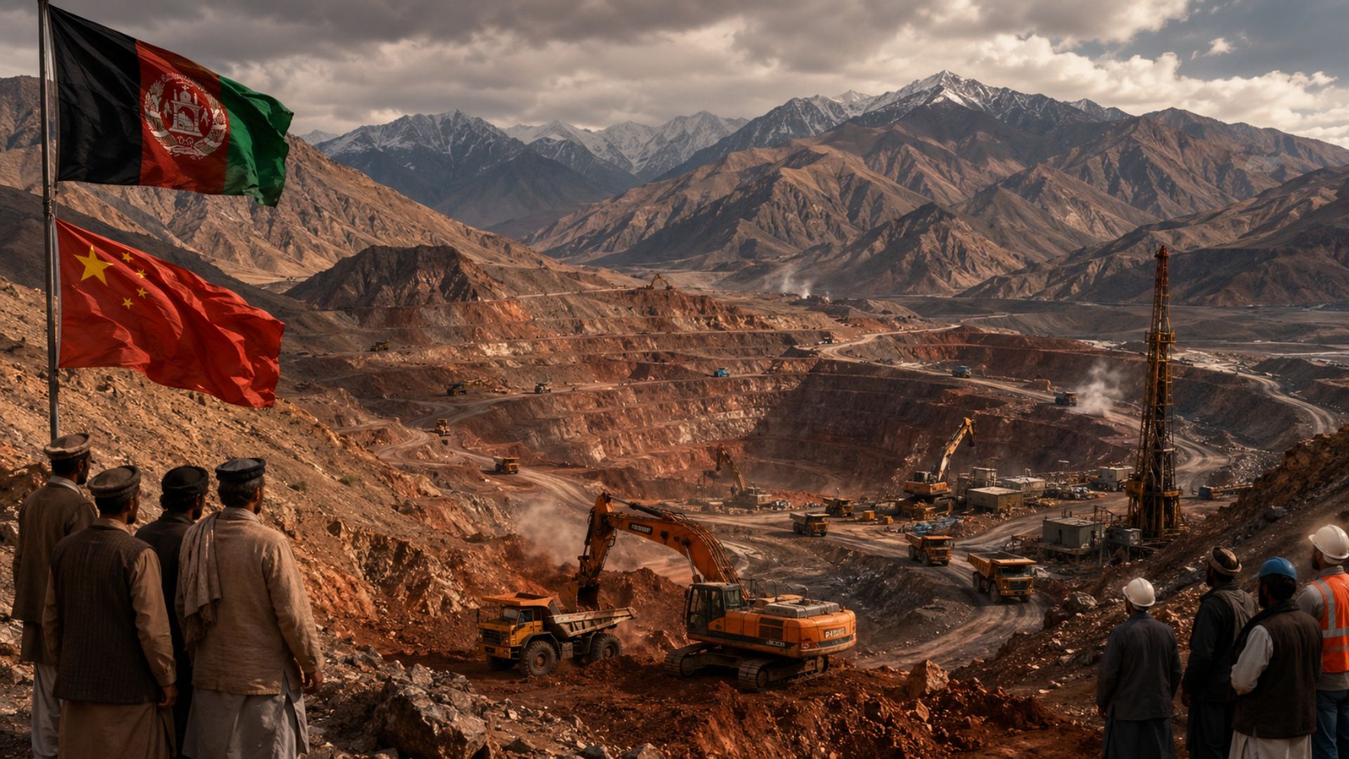
Afghanistan has one of the largest untapped copper reserves in the world, and China wants to control all of it with a billion-dollar deal that could change the fate of Asia’s poorest country.


Paths of Ibiapaba and the Connection of Three Biomes
In the higher sections of the mountain range, hikers encounter denser forest, constant breezes, and moist areas that contrast with the semi-arid surroundings, in a setting of viewpoints, waterfalls, and shaded trails that mark the beginning of the route.
Further along, the transition to the Caatinga becomes more pronounced in the landscape and soil, with vegetation adapted to drought and long open stretches, while community support points emerge as options for overnight stays and supplies for those continuing the trek.
Upon reaching the Sete Cidades National Park, the vegetation cover changes again, with rock formations standing out amid the greenery and areas where ecosystems meet, reinforcing the connectiveness character that guides the implementation of the trail.
Ubajara National Park, Cave and Waterfalls Along the Route

One of the most well-known points in the Ceará section is the Ubajara Cave, considered the main speleological heritage of the state, formed in limestone and with 1,120 meters of mapped extension, of which about 450 meters are open for visitation.
The visitation dynamics in the cave and the park trails are regarded as part of the public use planning, as the route integrates the larger set of the Paths of Ibiapaba and requires attention to safety and conservation rules in protected areas.
Between viewpoints and valleys, the trek also passes through rural properties and small businesses that provide food, water, and rest, forming a network of services that accompanies the progress of the trail toward the state border.
Comboieiros, Local Culture, and Community-Based Tourism
In addition to natural attractions, the trail was established along paths associated with regional commerce conducted by comboieiros, who crossed the mountains to transport goods between Ceará, Piauí, and Maranhão, in long journeys that shaped local settlement.
In this context, the Ministry of the Environment and Climate Change describes the route as a crossing that combines nature and culture, citing the revival of these historical paths as part of the design of the tourism product and the connection with communities.
According to the Director of Protected Areas at the ministry, Pedro da Cunha e Menezes, the route is already well-structured and has complete signage, and “it is a complete crossing, with natural and cultural elements and diverse usage possibilities.”
Sete Cidades National Park, Rock Formations and Rock Paintings

In Piauí, the Sete Cidades National Park features rock formations that, by their arrangement, resemble “small cities,” a characteristic that inspired the name of the unit, created on June 8, 1961, and managed by ICMBio.
The area also contains records of rock art, with paintings estimated to be around 6,000 years old, mentioned in institutional materials from the park, and which are complemented by viewpoints and internal trails as part of the visitor’s experience.
The presence of sites with engravings in the region of São João da Fronteira, locally known as “Pés de Ema,” appears in public records and local accounts, although the formalization and official detailing of the registration vary according to the stages of recognition.
RedeTrilhas, Signage, and Connectivity of Landscapes
The Paths of Ibiapaba are part of a set of 22 routes certified by the National Network of Long-Distance Trails and Connectivity, an initiative coordinated by the MMA and ICMBio, in partnership with the Ministry of Tourism.
The logic behind the implementation is to link conservation units through corridors and marked routes, expanding public use and landscape connectivity, while also creating a visitation structure that reduces improvisation in navigation.
In the project planning, Funbio reports that implementation needed to address private areas surrounding the units, and the coordination of the work emphasizes that generating social and economic value was crucial to reduce opposition and make the route feasible.
Project Funding and New Trails in Other Biomes

The development of the trail was led by the Brazilian Institute of Municipal Administration (IBAM), with support from the GEF Land program, under the technical coordination of the MMA, execution by Funbio, and participation of the IDB as implementing agency.
In the public call for the GEF Land program aimed at long-distance trails, Funbio reported a total amount of R$ 1.6 million for project selection in the Caatinga, Pampa, and Pantanal, including the structuring and sustainability of the Paths of Ibiapaba.
While the Northeast now has the first long-distance route crossing the Caatinga, the program itself points to two more routes in the final stages, one in the Pantanal and another in the Pampa, within the same strategy of expanding the network.
International Recognition and Competition for Hiking Destinations
In the global landscape, the International Union for Conservation of Nature approved a motion on October 9, 2025 recognizing trails as a conservation tool, an initiative presented by Brazil based on the experience of the Brazilian Trail Network.
With the arrival of the new trek, the public policy aims to respond to a growing market for multi-day hikes, while organizing rules, signage, and local services, to transform the route into a destination and not just a one-off adventure.
Now that the Serra da Ibiapaba has a marked path combining three biomes and cultural heritage, what is needed for other Brazilian routes to reach the same level of structure and attract hikers who today seek similar experiences abroad?


Sou Fco. Fortes Filho,tenho 64 anos e sou testemunha desta época. Era criança no início da década de 1970 e meu pai, o saudoso Fco. Fortes de Carvalho-(Chico Doca), tinha um comércio na localidade Boa Vista dos Cariocas-Esperantina-PI.
Esta localidade é o ponto mais próx entre a serra da Ibiapaba, o Piaui e o Maranhão.
Lembro que tinha um senhor conhecido como Didi, era um dos comboeiros que vendia cachaça serrana. O mesmo era da cidade de Mocambo, que fica próx de Ubajara. O mesmo vendia a cachaça p/ meu pai e seguia viagem para o Maranhão. Ele fazia esta rota sistematicamente. Esta rota tbm era usada pelos ciganos que sempre usavam esta mesma rota.
Muito bom, gostaria de saber a melhor época para fazer a travessia.