
 Portuguese
  Spanish
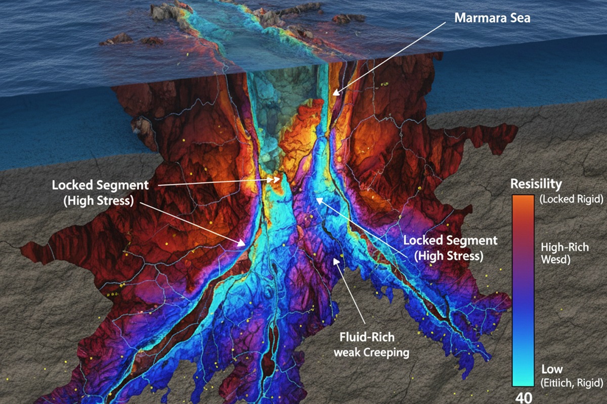
New 3D Mapping of the North Anatolian Fault Beneath the Sea of Marmara Reveals Areas of Tension Accumulation. Understand How Scientists Use Electromagnetic Data to Assess Earthquake Risk in Turkey.
Scientists monitoring seismic risk in northwestern Turkey have reached a historic milestone in geology: the creation of the first detailed three-dimensional image of the North Anatolian Fault beneath the Sea of Marmara. Although the fault’s location was known, its underwater behavior remained a mystery due to the difficulty of monitoring at depth.
This new analysis details how tension is accumulating in zones that haven’t ruptured in over two centuries, providing crucial data to understand the threat hanging over Istanbul.

The Dynamics of Earthquakes on a Massive Scale in Turkey
Turkey is situated at a complex meeting point of large tectonic plates. The constant movement between them is released through geological faults, with the North Anatolian Fault being the most prominent, extending roughly 1,500 kilometers. Since the devastating Erzincan earthquake in 1939, a series of significant ruptures has progressed westward, “walking” along the fault until reaching the gates of the Sea of Marmara, where monitoring becomes a technical challenge.
-
Helicopter Drops 180 Tons of Sand and Gravel on Swedish River to Revive Ecosystem Damaged by Decades of Exploitation

-
Brazilian Company Launches Retro Smartphone with 48 MP Camera, T9 Keyboard, and Privacy Features for Social Media-Free Use

-
Self-Taught Chinese Farmer Builds 5-Ton Submarine from Scrap, Launches It in Anhui River
-
Invisible Induction Technology Enables Wireless Power for Blenders, Coffee Makers, and Air Fryers, Reducing Countertop Cables


Electromagnetic Technology to Visualize the Invisible
Unlike the terrestrial sections, the marine segment of the fault is difficult to access for permanent instruments. To overcome this barrier, the research team used magnetotelluric data. This technique measures natural variations in the Earth’s electric and magnetic fields to identify how electricity flows through rocks at depths of several kilometers.

The resulting model revealed a “mosaic” of geological properties:
- Low Resistivity Zones: Fluid-rich and mechanically weak areas where tension is gradually released through small tremors.
- High Resistivity Zones: Rigid and “locked” areas. At these points, energy is not released gradually but rather accumulated over decades, increasing the potential for a large seismic event.
Improving Risk Assessment
Although the study does not predict when the next earthquake will occur, it fundamentally changes how experts assess danger. By identifying where rocks are stronger and where fluid accumulations are located, scientists can better understand which segments of the fault are more likely to initiate a large-scale rupture.
This information is vital for urban planning and preparedness efforts in Istanbul. Understanding the deep structure of the North Anatolian Fault allows for more accurate risk models, helping to protect millions of people living within the influence zone of this unstable geological system.
This article was based on information from The Times of India, published on February 1, 2026, which reports on the mapping of hidden fault lines beneath the Sea of Marmara by scientists, with potential implications for major earthquakes in Turkey.


-

1 person reacted to this.