 Portuguese
  English
  Spanish
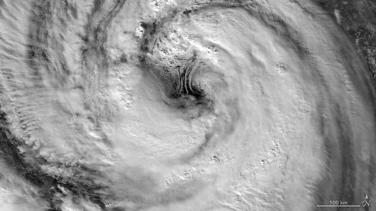
Nighttime satellite images recorded Typhoon Jangmi with an eye larger than average as the system slowly advanced through the Philippine Sea, causing intense rain in Japan and maintaining alerts for Okinawa, Amami, and areas of the Pacific coast.
NASA recorded Typhoon Jangmi with a giant eye visible from space as the storm slowly advanced through the Philippine Sea, heading towards southern Japan, between the end of May and the beginning of June 2026.
Giant eye appeared in NASA nighttime image
The image was captured on May 30, around 16:40 UTC, by the VIIRS instrument aboard the Suomi NPP satellite. In Japan, the record corresponded to 1:40 on May 31.
At that moment, the Joint Typhoon Warning Center indicated sustained winds of 120 kilometers per hour, averaged over 1 minute. The speed was comparable to a category 1 hurricane on the Saffir-Simpson scale.
-
Nvidia built the infrastructure of artificial intelligence and became the largest company in the world, but Jensen Huang now needs to defend his throne against Huawei, Google’s TPUs, chip startups, and customers who want to escape dependence on more expensive GPUs.

-
Hidden beneath the dense vegetation of Mexico, a Maya settlement reveals 80 structures, a colorful mural, a monumental plaza, and structures up to 14 meters tall that may be just the beginning of an even larger ancient city.

-
Brazil has 130,000 diesel buses, but electric ones still face challenges outside São Paulo: fleet grows by 170%, city concentrates more than 80% of the vehicles, and costs of up to R$ 3 million expose financing and infrastructure bottlenecks in Brazilian public transportation.
-
China presents a conceptual design for a 242-meter, 120,000-ton space aircraft carrier, promising to carry drones and hypersonic missiles to the stratosphere, reigniting the debate on science fiction, military intimidation, and the next frontier of wars beyond Earth in the future of humanity.


The image clearly showed the eye of the storm and the wall around it. Scott Braun, a research meteorologist at NASA’s Goddard Space Flight Center, assessed that the eye was larger than the average of many tropical cyclones.
Braun also identified signs of rotation at low altitudes on the east side of the eye. These structures, known as mesocyclones, appeared under higher clouds and were described as normal features in storms like Jangmi.
Typhoon gained strength near Okinawa
A second image, captured on May 31 by the VIIRS on the NOAA-20 satellite, showed the typhoon more intense. The record occurred again around 16:40 UTC, equivalent to 1:40 on June 1 in Japan.
At this stage, sustained winds had risen to 130 kilometers per hour. The center of the storm remained south of Okinawa, but outer cloud bands were already reaching parts of Japan.
Forecasts indicated passage near Okinawa before advancing northeast towards Amami between June 1 and 2. The storm was also expected to maintain significant rain, especially on the Japanese Pacific coast.
What caught your attention most in the images of Typhoon Jangmi seen from space: the size of the eye, the strength of the winds, the risk of intense rains in Japan, or the ability of satellites to capture such precise details at night?


Be the first to react!