Portuguese
  Spanish
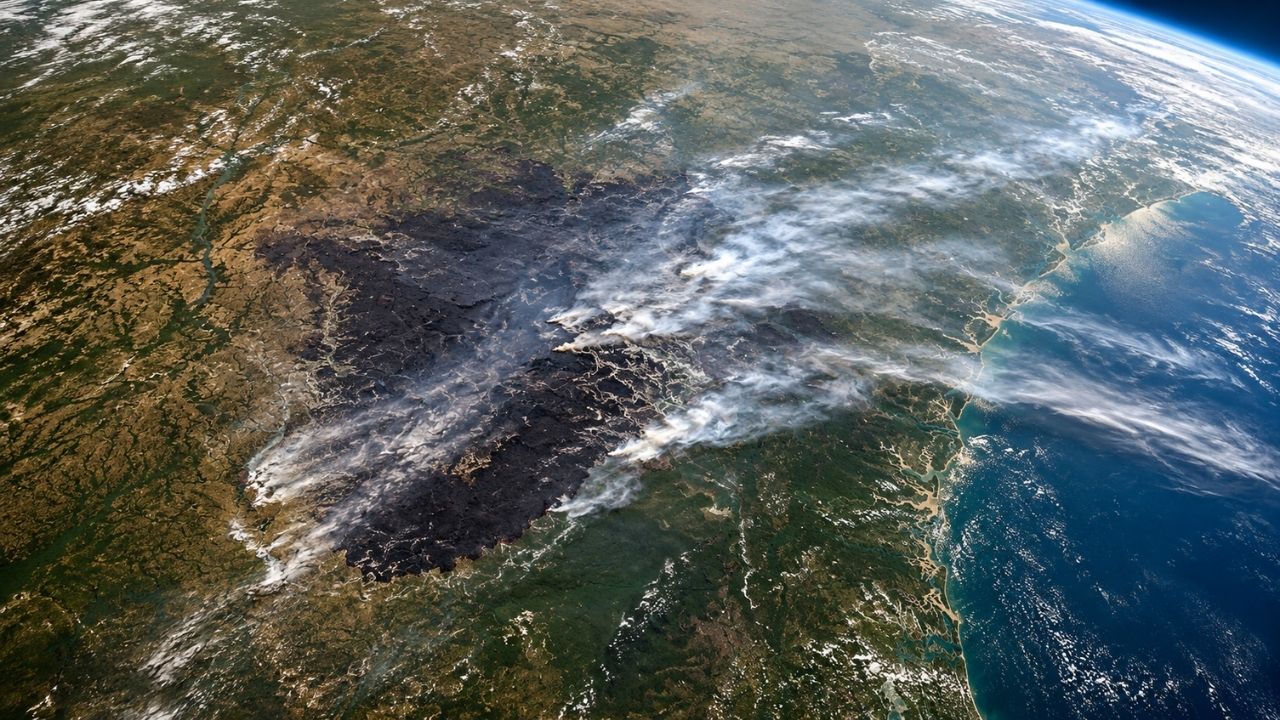
Wildfires on Pineland Road and Highway 82 together burned about 22,250 hectares in southern Georgia, USA, in 2026, while an image from NASA’s Landsat 8 revealed the gray scar caused by extreme drought, winds, fuel left by Hurricane Helene, and still active risks for nearby local communities.
The wildfires in the southern state of Georgia, United States, gained spatial dimension after NASA released a satellite image showing the mark left by the fire in 2026. The outbreaks on Pineland Road and Highway 82 advanced over about 54,995 acres, equivalent to approximately 22,250 hectares.
According to a report by Ecotícias, the official update on May 7, 2026, indicated that the fires remained active, although with progress in containment. The flames reached areas near Atkinson and Fruitland, in a scenario aggravated by extreme drought, winds, and vegetative debris knocked down by Hurricane Helene, which passed through the region in September 2024.
NASA showed the fire scar seen from space

The image recorded by the Landsat 8 satellite revealed a large grayish stain over southern Georgia. Seen from the ground, the tragedy appears in the form of smoke, destroyed houses, closed roads, and emergency teams. From space, it emerges as an extensive scar on the territory.
-
Astronomers Use James Webb Telescope Data to Trace the Path of Giant Exoplanet WD1856b, Which Survived Its Star’s Destruction and Migrated to a Close Orbit 80 Light-Years from Earth

-
After 79 Attempts, Students Create Corn Waste Bioplastic That Turns into Fertilizer and Grows Plants When Buried
-
Brazilian Public School Students Win $5,000 at World’s Largest Science Fair with Innovative Water Filter Made from Local Charcoal

-
Xiaomi Launches 17T in Brazil with 120x Zoom, 6,500 mAh Battery, and Leica Cameras to Rival iPhone


The contrast is strong because the image turns the fire into a visible mark on the map. The burned areas appear in gray, the preserved vegetation in green, and the still active fire points appear in orange tones, due to the infrared signature captured by the sensor.
The instrument used was the OLI, short for Operational Land Imager, installed on Landsat 8. This type of observation allows monitoring the extent of the damage, comparing affected areas, and supporting decisions during environmental emergencies.
The scene also shows how wildfires can change a landscape in a few days. What was once continuous vegetation cover now appears as a dark strip, revealing the speed at which the fire can advance when it finds favorable conditions.
Extreme drought left the land ready to burn
The severity of the fires is not explained solely by the origin of the flames. Southern Georgia was facing a period of intense drought, with low humidity, little rain, and winds capable of quickly pushing the fire through areas of dry vegetation.
When the soil and vegetation lose moisture, any spark can become an emergency. It is at this point that wildfires cease to be isolated episodes and become a regional risk to communities, roads, crops, and natural areas.
Another aggravating factor came from the recent past. Remnants of trees and branches left by Hurricane Helene in September 2024 remained on the ground as accumulated fuel. This dry material helped feed the flames.
In practice, the region had a dangerous combination: dried vegetation, forest debris, wind, and sources of ignition. This combination explains why the fire spread so forcefully and left a mark large enough to be seen from space.
Pineland Road and Highway 82 totaled more than 22 thousand hectares
According to the official update on May 7, 2026, the Pineland Road fire had burned 32,575 acres and was 66% contained. Meanwhile, the Highway 82 fire totaled 22,420 acres, with 85% containment.
Together, the two wildfires reached 54,995 acres, about 22,250 hectares. Containment, however, does not mean extinction. It means that teams have managed to establish control over part of the perimeter, but there is still a risk of advancement, reignition, or active points.
This detail is important because the NASA image may give the impression of an already concluded event. In reality, the fieldwork continues even after the fire stops advancing forcefully.
Teams need to reinforce control lines, monitor hot areas, protect communities, and prevent winds or local climate changes from reigniting seemingly stabilized sections.
Origin of the fires involved human actions
The causes pointed out for the two fires show how common actions can cause enormous damage when the environment is dry. In the case of Pineland Road, the origin was attributed to a spark from a welding operation that fell on the forest floor.
In the Highway 82 fire, the indicated cause was a Mylar balloon that touched a power line and caused an electrical arc. On a normal day, these episodes might seem small; in a dry landscape, they became triggers of destruction.
This point reinforces the importance of prevention. Activities that generate sparks, improper disposal of materials, use of outdoor fire, and metallic objects near power lines can become dangerous during drought periods.
The Georgia Forestry Commission maintained alerts to avoid practices capable of starting new fires. Recommendations include not driving over dry grass, not using fireworks, properly extinguishing cigarettes, and respecting burn restrictions.
Houses, roads, and communities felt the impact
The scar seen by NASA does not just represent burned vegetation. By April 25, the fires had already destroyed more than 120 houses, according to reports cited by the space agency. This data places the tragedy among the most severe episodes of its kind in the state.
Each burned hectare carries human and economic consequences. Families lose homes, roads are blocked, rural properties suffer losses, commercial timber is affected, and entire communities have to deal with smoke, fear, and uncertainty.
In the case of Pineland Road, the official report cited 140 civilians affected, with no civilian deaths, injuries, or missing persons recorded in that fire. There was also a record of an injury or illness involving a person responding to the fire.
Additionally, road sections in areas like Echols and Clinch remained restricted due to operations. Containing wildfires requires space, air safety, ground access, and constant coordination.
State of emergency expanded the official response
Georgia Governor Brian Kemp declared a state of emergency in 91 counties on April 22, 2026. The measure was adopted due to the combination of extreme drought and the advance of fires in the southern part of the state.
The declaration allowed for the mobilization of state resources, including support from the Georgia National Guard, helicopters, evacuation teams, debris removal, and support for field operations.
In fires of this magnitude, every hour counts. The response involves not only extinguishing visible flames but also preventing the fire from crossing control lines, protecting inhabited areas, and reducing the risk of new outbreaks in vulnerable locations.
Coordinated action between firefighters, environmental authorities, aerial teams, and state agencies is essential because the fire does not respect administrative boundaries. It advances according to wind, terrain, humidity, and available fuel.
Satellites help measure the disaster and guide decisions
The Landsat 8 image is not just for impressing the public. It is part of a monitoring network used to observe fires, measure burned areas, and support decisions during emergencies.
NASA also uses tools like FIRMS, Worldview, and Fire Event Explorer to track heat spots and fire events in different parts of the planet. These systems help turn spatial data into useful information for ground response.
For environmental teams, satellite vision allows them to see the scale of the problem. In large areas, with smoke, blocked roads, and difficult terrain, orbital observation helps identify patterns that are not always visible from the ground.
This type of technology can also be used after the emergency, in recovery planning. Burned areas need to be assessed for erosion risk, vegetation loss, impact on wildlife, and the possibility of new fires.
The warning left by Georgia’s scar
The wildfires in Georgia show how a combination of drought, wind, plant debris, and small ignition sources can create a large-scale disaster. The NASA image only makes visible a transformation that residents and emergency teams already felt on the ground.
The gray scar seen from space serves as an environmental warning. It shows that prevention, vegetation management, care with risky activities, and quick response are as important as directly fighting the flames.
In times of more severe droughts and extreme weather events, fires can cease to be local episodes and turn into regional crises. The case of Georgia reinforces that dry landscapes need constant vigilance.
Do you think satellite images help the population better understand the severity of wildfires, or does the real impact only appear when houses, roads, and communities are affected? Leave your opinion in the comments.