
 Portuguese
  Spanish
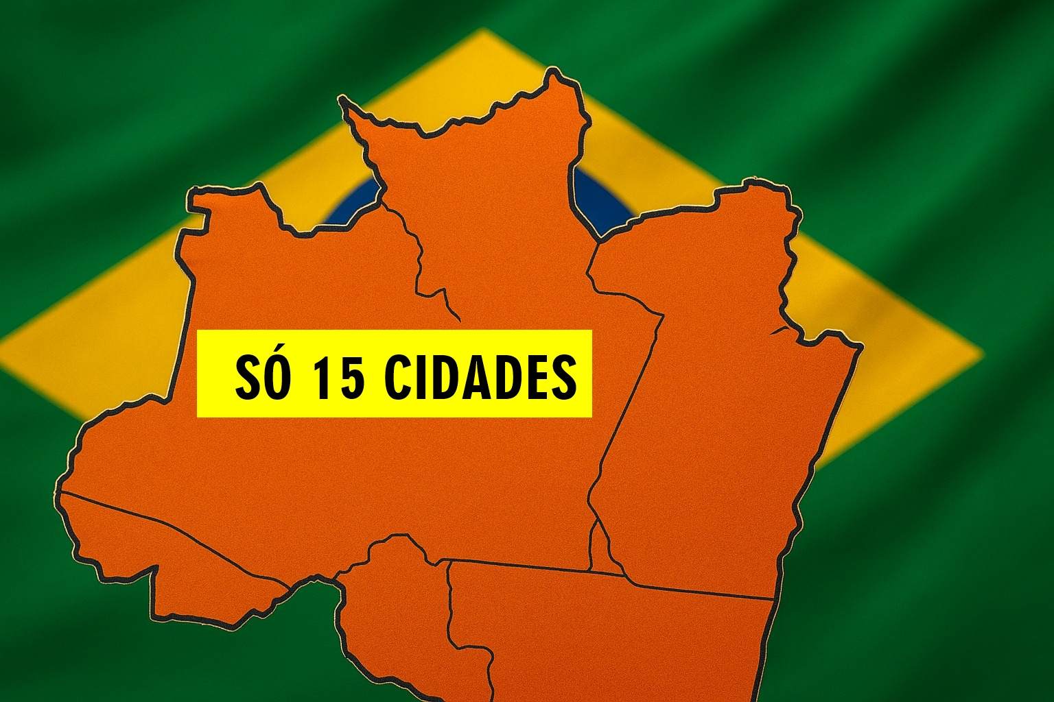
With Only 15 Municipalities Spread Over More Than 223 Thousand km² and Borders With Two Countries, This State Concentrates More Than 65% of the Population in a Single City and Has a Strategic Role in the Amazon
Amid the 26 Brazilian states, there is one that stands out for a rather unusual characteristic: it has very few cities, even occupying an immense territorial extension.
While other federal units can house hundreds of municipalities, this one remains with just over a dozen, revealing a history of recent formation, a slow process of occupation, and unique development challenges in one of the country’s most remote regions.
Meet The State With The Fewest Municipalities In Brazil
With Only 15 Municipalities Distributed Over More Than 223 Thousand km², Roraima Occupies A Unique Position On The Brazilian Political Map.
-
From matches sold by bicycle at age 5 to a global furniture empire: the lumberjack’s son founded IKEA at 17 in his uncle’s kitchen and transformed a small company into the largest furniture retailer on the planet.

-
The mansion in Flamengo, built in 1865 for the Baron of São Clemente and closed for 20 years, has become a spa, event hall, and gym for “Symphony,” a luxury condominium that sold 70% of its gross development value in the first month on the R$ 60 million land of the former Bennett College.

-
The Ipiranga convent, a 1924 building adjacent to the Museum that remained vacant for a decade and became home to dozens of cats, is reborn as “Alma Mater,” a luxury development worth R$ 130 million with a pool in the courtyard and a clubhouse in the former nuns’ chapel.

-
An empty pool of almost 3 meters turned into tilapia farming in the backyard after a family transformed the dangerous space for children into an urban greenhouse with eggs and organic food.


It Is The State With The Lowest Number Of Cities In The Country, A Characteristic That Reflects Its Recent History, Low Population Density, And The Challenges Of Occupation And Development In One Of The Most Isolated And Fascinating Regions Of The National Territory.
Roraima Is The Only Brazilian State Entirely Located In The Northern Hemisphere. It Is Above The Equator Line, Which Influences Its Climate And Solar Lighting Patterns.
A Young Territory In The Brazilian Federation
Roraima Is One Of The Newest States In Brazil, Officially Created In 1988, With The Promulgation Of The Federal Constitution.
Before That, The Region Was Known As The Federal Territory Of Rio Branco, Later Renamed As The Federal Territory Of Roraima In 1962.
Its Elevation To The Status Of State Marked A New Stage In The Process Of Integrating The Amazônia With The Rest Of The Country, Encouraging Migration, Urbanization, And The Formation Of A Regional Economy.
The Youth Of Roraima Explains In Part The Small Number Of Municipalities.
While Older States Had Centuries To Divide Territories And Create New Cities, Roraima Is Still In A Relatively Early Process Of Political-Administrative Consolidation.
The Geography That Makes It Difficult To Create Cities
With An Area Of 223,644 km², Roraima Has Dimensions Comparable To Those Of The United Kingdom. Despite This, Its Population Is About 650 Thousand Inhabitants, The Smallest In Brazil.
According To Data From IBGE, In 2010, The State Of Roraima Had 451,227 Inhabitants. An Update Showed That The State Had A 41.25% Increase Compared To The Previous Census.
This Low Population Density – About 2.85 Inhabitants Per km² – Is One Of The Main Reasons Why The State’s Administrative Division Remains Limited.
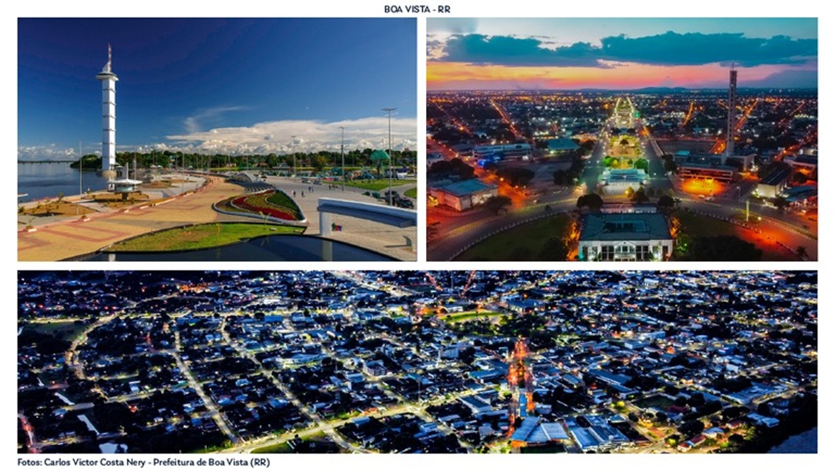
The Capital, Boa Vista, Concentrates More Than 65% Of The Inhabitants, Being Not Only The Political And Economic Center But Also The Dominant Urban Hub.
The Rest Of The Population Distributes Across Small Towns And Isolated Communities, Many In Hard-To-Access Areas.
The Presence Of Indigenous Lands, Environmental Conservation Units, And Vast Areas Of Amazon Forest Also Limits Urban Expansion And Makes It Difficult To Create New Municipalities.
The 15 Municipalities of Roraima And Their Most Recent Populations (Census 2022 Or Closest Estimates), Without Links:
| Municipality | Approximate Population |
|---|---|
| Alto Alegre | 21,096 Inhabitants |
| Amajari | 13,927 Inhabitants |
| Boa Vista | 413,486 Inhabitants |
| Bonfim | 13,923 Inhabitants |
| Cantá | 18,682 Inhabitants |
| Caracaraí | 20,957 Inhabitants |
| Caroebe | 10,656 Inhabitants |
| Iracema | 10,023 Inhabitants |
| Mucajaí | 18,095 Inhabitants |
| Normandia | 13,986 Inhabitants |
| Pacaraima | 19,305 Inhabitants |
| Rorainópolis | 32,647 Inhabitants |
| São João da Baliza | 8,858 Inhabitants |
| São Luiz | 7,315 Inhabitants |
| Uiramutã | 13,751 Inhabitants |
Strategic And Border Importance
Despite Being Small In Number Of Cities, Roraima Has Enormous Strategic Relevance For Brazil. The State Shares A Border With Venezuela And Guyana, Which Gives It An Important Role In Foreign Policy, Trade, And National Security.
Its Location Also Makes It An Entry Route For Migratory Flows, Especially Venezuelans In Recent Years.
Additionally, The Region Has Vast Natural Potential, Highlighting Mineral Resources, Biodiversity, And Areas Suitable For Agriculture And Energy Generation.
This Potential Has Attracted Investments And May, In The Future, Boost The Creation Of New Cities As Infrastructure Develops.
Curiosities And Emblematic Cities
Among The 15 Municipalities of Roraima, Some Stand Out For Their Particularities. Pacaraima, For Example, Is Located On The Border With Venezuela And Is One Of The Main Entry Points For Immigrants.
Caracaraí, On The Banks Of The Rio Branco, Was The First City In The State And Played A Historical Role In The Occupation Process.
Uiramutã Is Known For Being The Northernmost Municipality In Brazil, Marking The Northernmost Extreme Of The National Territory.
A Small State In Number Of Cities, Large In Potential
Roraima Is, Therefore, A Peculiar Case In The Brazilian Scenario. Its Reduced Number Of Municipalities Does Not Represent Fragility, But Rather A Combination Of Historical, Geographical, And Demographic Factors That Have Shaped Its Identity.
Young And Still In The Process Of Urban Expansion, The State Faces A Great Potential For Sustainable Development, Regional Integration, And Strategic Protagonism In The Amazon And Brazil’s Borders.
With Only 15 Cities, Roraima Shows That Size Is Not Synonymous With Importance — And That Even The Smallest Administrative Division In The Country Can Play A Decisive Role In The National Future.
| Information | Data |
|---|---|
| Governor | Antonio Oliverio Garcia de Almeida (2023) |
| Capital | Boa Vista |
| Demonyms | Roraimense |
| Land Area | 223,505.385 km² (2024) |
| Population In Last Census | 636,707 People (2022) |
| Population Density | 2.85 inhab/km² (2022) |
| Estimated Population | 738,772 People (2025) |
| Enrollments In Primary Education | 112,790 Enrollments (2024) |
| HDI (Human Development Index) | 0.699 (2021) |
Mount Roraima
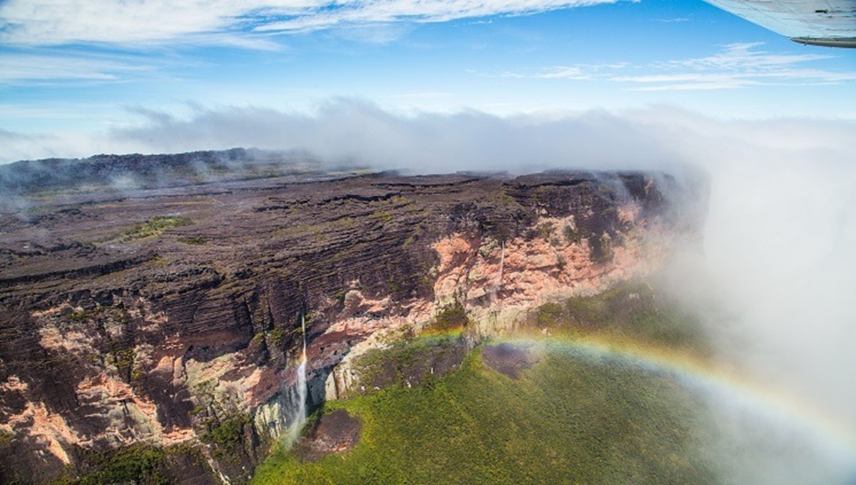
Mount Roraima Is One Of The Most Impressive Geological Formations In South America And One Of The Highest Points In Brazil, At 2,875 Meters Above Sea Level.
Located At The Triple Border Between Brazil, Venezuela, And Guyana, It Stands Out For Its Flat “Table” Top, The Result Of Millions Of Years Of Erosion.
Surrounded By Vertical Cliffs Up To 400 Meters High, The Mountain Houses Unique Ecosystems And Endemic Species, As Well As Indigenous Legends That Consider It A Sacred Site.
Its Beauty And Mystery Inspired Literary Works, Such As “The Lost World” By Arthur Conan Doyle, Making The Place A Coveted Destination For Adventurers And Nature Lovers.
Reaching The Top Requires At Least Three To Four Days Of Hiking, Depending On The Physical Fitness And Pace Of Each Visitor.
The Route Passes Through Trails With Rivers And Waterfalls, Making The Journey Challenging And Requiring Planning.
Therefore, It Is Recommended To Hire A Guide Or Specialized Agency Before The Trip, As Many Companies Only Conduct The Trekking With A Minimum Number Of Participants.
It Is Also Essential To Confirm That The Service Provider Is Registered With Cadastur — The Official Registration Of The Ministry Of Tourism. Since Visits Are Controlled, It Is Important To Check The Availability Of The Tour In Advance.


Roraima é atravessado pelo Equador, e, possui a maior parte do território situado no hemisfério norte, consequentemente, a menor fica no hemisfério sul. Basta uma visualização do mapa 🗺️.
O estado mais novo da federação é Tocantins.