Portuguese
  Spanish
There Were Nine Days of Global Seismic Vibrations, and No One Had an Explanation. Now, Scientists Reveal: The Blame Was a Colossal Landslide in the Arctic
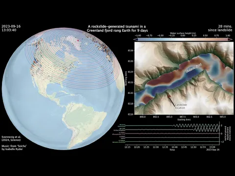
In September 2023, scientists around the globe were intrigued by an unusual phenomenon: a low-frequency seismic signal that repeated every 90 seconds and lasted no less than nine consecutive days. A month later, the same type of vibration was recorded again, this time for a week. What seemed inexplicable at first now has a surprising — and frightening — answer: the origin of the megatsunami was located in Greenland.
The Silent Collapse in the Arctic
In the remote Dickson Fjord, located in eastern Greenland, a gigantic slope over 1,200 meters high collapsed, unleashing about 25 million cubic meters of rock and ice directly into the waters of the fjord. The impact generated a megatsunami with waves that would have reached an impressive 200 meters in height, a force comparable to that of a multiple launch of large rockets.
The geographical structure of the fjord — narrow, deep, and surrounded by rock walls — caused the waves to become “trapped”, creating a phenomenon known as seiche, a standing wave that goes back and forth as if being shaken inside a giant container. This violent and continuous oscillation was so intense that it caused vibrations in the Earth’s crust, felt by seismographs on all continents.
-
400 km² of Greenhouses in Almería, Spain, Astonish American Visitor by Producing Millions of Tons of Produce for Cold-Weather Markets

-
Antarctic Volcano Emits Microscopic Gold Particles That Travel Up to 1,000 Kilometers Across the Continent
-
Little-known Japanese factory is the world’s largest zipper manufacturer, producing 7 billion pieces annually and closing half the world’s pants.

-
Brazilian Factory Recycles One-Third of the Country’s Styrofoam Waste, Matching European Levels with 51,000 Tons Reused Since 2007


The Science Behind the Confirmation
For a long time, the suspicions about the origin of these seismic signals were based solely on computational models and simulations. But that changed with the arrival of a new generation of satellites capable of observing remote regions with unprecedented precision.
Researchers from a British university used data from a satellite launched at the end of 2022, equipped with high-resolution sensors that allowed them to map, for the first time, the height of the water surface within the affected fjord. They identified variations of up to two meters in the elevation of the water in opposite directions, confirming the existence of the seiche caused by the tsunami.
Moreover, the scientists cross-referenced this information with seismic records and small deformations detected in the Earth’s crust, even thousands of kilometers away from Greenland. Thus, they were able to reconstruct the parameters of the event, even during the time windows when the satellite had not passed through the area.

The Alert of Climate Change
This unprecedented event is a clear warning of how climate change is affecting regions previously considered stable. The accelerated melting of glaciers, combined with the thawing of permafrost, has left entire slopes unstable, causing landslides that can generate destructive tsunamis.
Although the megatsunamis in Greenland did not reach inhabited areas, their consequences were felt globally. It is a reminder that extreme events, even occurring in remote areas, can have global repercussions — and that unstable climate may be the trigger for new natural disasters.
A New Horizon for Science
The use of advanced space technology, such as satellites for topographic mapping of the ocean surface, has opened a new era for the study of oceans and extreme events. For the first time, it has been possible to directly observe the internal dynamics of a post-tsunami fjord, something that was previously impossible with conventional satellites.
For scientists, the discovery represents a watershed: it will now be possible to identify and understand tsunamis, storms, and giant waves much more quickly and accurately. It also enables the anticipation of risks in vulnerable regions, improving early warning systems and the response to natural disasters.