Portuguese
  Spanish
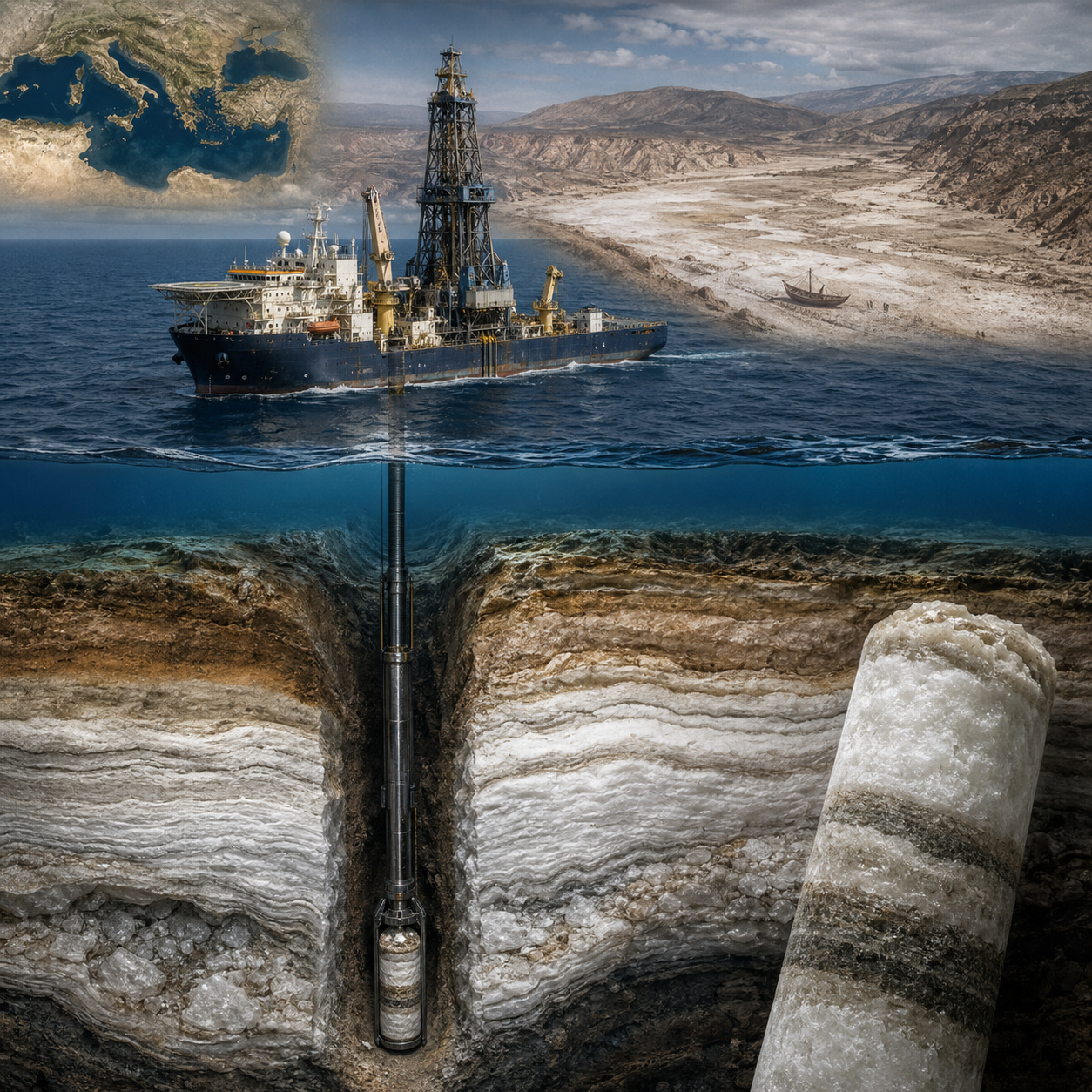
Glomar Challenger’s drilling revealed salt and gypsum at the bottom of the Mediterranean and exposed the debate about the sea that almost dried up.
According to Knowable Magazine, in a report published on February 9, 2026, the scientific drilling vessel Glomar Challenger returned to the port of Lisbon, Portugal, on October 6, 1970, carrying sediment cores that would change the modern interpretation of the geological history of the Mediterranean Sea.
During a 54-day expedition, the vessel drilled 28 sites on the seabed as part of Leg 13 of the Deep Sea Drilling Program, and the extracted materials indicated an extreme conclusion: about 6 million years ago, the Mediterranean underwent a salinity crisis capable of transforming it into an immense hypersaline basin, partially dried out and covered by salt deposits.
How the Glomar Challenger found gypsum, salt, and gravel at the bottom of the Mediterranean
At the first drilling site, the Glomar Challenger‘s drill bit got stuck in an extremely hard layer about 200 meters below the seabed. The next day, the two chief scientists of the expedition, Kenneth Hsü of ETH Zürich and William Ryan of the Lamont-Doherty Earth Observatory, understood why: the drill had brought buckets of gravel to the surface.
-
She spent 73 years breathing inside an iron lung, survived the aftereffects of polio, and became the last woman in the United States dependent on the equipment before dying at 78 years old.

-
Brazilian students created a $1 filter using pine bark, cotton, and 3D-printed parts to clean cassava wastewater, reduce the toxicity of a hazardous waste, and transform contaminated water into biofertilizer.

-
Astronaut from Artemis II steps down after mission to the Moon and decision surprises after a record of 406,771 km, a historic 10-day journey, and an unprecedented achievement for Canada.

-
A fossil kept for years in a small museum in Montreal concealed 450-million-year-old soft tissue, a discovery that has only happened once before in history.


This detail immediately caught their attention because deep ocean floors do not usually feature gravel beds like those, especially when mixed with marine fossils and gypsum crystals.

Gypsum is classified by geologists as an evaporite, that is, a rock associated with mineral precipitation in environments of high evaporation. In today’s world, this type of formation appears in shallow bodies of water with high salt concentrations, such as the Dead Sea.
Therefore, finding gypsum associated with marine fossils in deep Mediterranean sediments was a geological sign that was hard to ignore. At that depth, the presence of this material suggested that the sea had gone through a phase of isolation, extreme saline concentration, and a severe drop in water level.
The expedition repeated the pattern at different points in the Mediterranean. Hsü, Ryan, and the team found evaporites such as gypsum, halite, anhydrite, and other salts associated with intense seawater evaporation. The Deep Sea Drilling Project‘s own report recorded the discovery of a widespread evaporite formation beneath the floors of the deep basins drilled, a finding that reinforced the regional dimension of the phenomenon and removed the salinity crisis from the realm of local hypotheses.
The hydrological logic that makes the Mediterranean a basin vulnerable to evaporation
The hydrological logic of the Mediterranean is simple and brutal. The sea loses more water through evaporation than it receives from rain and rivers. This deficit is compensated by the inflow of water from the Atlantic Ocean through the Strait of Gibraltar. Without this replenishment, the water level would drop rapidly, and the salinity would increase until it reached extreme conditions for common marine life.
Knowable Magazine itself explains that, in the current Mediterranean, the annual loss from evaporation is much greater than the water recovered through precipitation and rivers, and that the Atlantic maintains the balance through the constant flow through Gibraltar.

In the classic calculations used by the Deep Sea Drilling Project team, the Mediterranean, without the Black Sea, has an approximate area of 2.5 million square kilometers and a volume of about 3.7 million cubic kilometers. The same report calculated a net evaporative loss of approximately 3,310 cubic kilometers per year, compensated by the Atlantic inflow. This explains why the closure or severe narrowing of the connection with the Atlantic would have rapid consequences on a geological scale.
For decades, the most dramatic interpretation held that if the Strait of Gibraltar were closed, the Mediterranean could dry up in just over a thousand years. More recent research, however, has adjusted this picture.

A study released by the CNRS on November 18, 2024, based on chlorine isotopes in salts extracted from the Mediterranean seabed, indicates that the crisis occurred in two phases: a first stage of about 35,000 years, concentrated in the eastern Mediterranean, and a second phase of rapid drawdown, lasting less than 10,000 years, during which the level dropped between 1.7 and 2.1 kilometers in the east and about 0.85 kilometers in the west, with a loss of up to 70% of the basin’s water volume.
Messinian Salinity Crisis began 5.96 million years ago and created a salt giant under the sea
The event is known as the Messinian Salinity Crisis. It occurred between approximately 5.97 and 5.33 million years ago, at the end of the Miocene, when the connection between the Mediterranean and the Atlantic was drastically restricted. The prevailing interpretation associates the phenomenon with the interaction between tectonics, sea-level variations, and a dry regional climate, in a context where the collision between the African and Eurasian plates was modifying the region’s marine gateways.
The result was the formation of the so-called Mediterranean Salt Giant. This subterranean layer, discovered during scientific drilling in the early 1970s, is described by researchers as a kilometer-thick formation beneath the Mediterranean seabed. The SaltGiant scientific project states that the deposit can exceed 3 kilometers in thickness in the deep basins and contains more than 1 million cubic kilometers of evaporitic salts, mainly halite and gypsum.
The scale of the deposit shows that the phenomenon was not a simple local episode of salinization. Knowable Magazine notes that the salt accumulated in the Mediterranean represents about 5% of the salt in the world’s oceans, and may have originally corresponded to a proportion between 7% and 10% before subsequent processes of dissolution, deformation, and burial. In geological terms, this means that an entire marine basin functioned as a natural salt factory on a continental scale.
The dry Mediterranean seabed could have been kilometers below the global ocean level
Imagining an almost dry Mediterranean requires abandoning current geography. What today appears as a continuous sea between Europe, North Africa, and the Middle East may have become, in extreme phases, a colossal depression, with isolated brines, salt flats, and exposed continental slopes.
In some classic models, the floor of the deepest basins would have been between 2 and 4 kilometers below the global ocean level, creating a landscape with no direct equivalent in the modern world.
This image, however, must be treated with precision. Current science still debates the exact degree of desiccation. Some models advocate for an almost total drop in water level, while others maintain that deep parts of the basin may have remained covered by dense, hypersaline brines.

The review published by Annual Reviews in 2025 summarizes this very dispute: the hypothesis of an extreme drawdown and a catastrophic refilling has become very influential, but recent studies suggest that the Atlantic-Mediterranean connection may have remained active at times and that more gradual processes also need to be considered.
Even so, even the less extreme scenarios still point to an extraordinary geological environment. A Mediterranean with a loss of up to 70% of its volume, a drop of more than 1 kilometer in part of the basin, and the deposition of salts on a kilometer scale would have been enough to reshape rivers, continental margins, marine ecosystems, and regional circulation.
The central question today is not whether there was a crisis, but exactly how it occurred, at what pace, and with what actual depth of drawdown.
The crisis was not a single, simple collapse, but a sequence of salt, gypsum, and brine phases
The Messinian Salinity Crisis lasted about 630,000 years, but it did not behave as a linear event. Recent research indicates a sequence of phases, with gypsum deposition, saline concentration, halite precipitation, possible partial reconnections with the Atlantic, and influxes of fresh or brackish water from continental systems. This is why many geologists treat the event as a dynamic crisis, and not as a simple “sea that dried up all at once.”
The phase known as Lago Mare is one of the most intriguing. It marks the final stage of the crisis, when the Mediterranean seems to have received less salty water, possibly linked to the system of the ancient Paratethys, an immense set of seas and lakes that occupied parts of Eastern Europe and Asia.
Knowable Magazine states that recent research suggests this very possibility: the Mediterranean may have been partially recharged by fresh or brackish water from the east, while global sea-level oscillations also interfered with the basin’s configuration.
This alternation helps explain why the layers of evaporites appear associated with signs of different environments. In some places, there are minerals typical of concentrated brines. In others, there are fossils compatible with less saline waters.
The very scale of the salt deposit requires multiple water inflows or long periods of restricted circulation, because a single complete evaporation of the Mediterranean’s current volume would not be sufficient to produce all the observed salt mass.
The Zanclean Flood became one of the most famous geological hypotheses on the planet
The end of the Messinian Salinity Crisis is traditionally associated with the so-called Zanclean Flood, which occurred about 5.33 million years ago, when the Atlantic would have once again flooded the Mediterranean through the region of the current Strait of Gibraltar. In the classic version, the water would have progressively eroded the rock barrier until it opened a growing passage, producing a flood of planetary scale in terms of flow rate.
This hypothesis gained strength because it offers a powerful image: the Atlantic entering a lowered basin, accelerating erosion, widening the channel, and filling the Mediterranean in a geologically very short interval.

Models published in 2009 even suggested that much of the refilling could have occurred in a few months or a few years, with peak flow rates far exceeding those of the largest modern rivers.
The University of Southampton, when releasing a study on January 21, 2025, stated that new evidence in southeastern Sicily pointed to a megaflood associated with the end of the crisis.
For decades, this narrative dominated the scientific and popular imagination. Kenneth Hsü went so far as to describe the scene as a gigantic waterfall at Gibraltar, and the idea was spread in documentaries and outreach materials. The problem is that the more geological data were accumulated, the more complex the story became.
New research questions whether the Gibraltar megaflood happened as the classic version describes
The 2026 report from Knowable Magazine highlights the most sensitive point of the debate: the megaflood may not have occurred in the catastrophic, simple, and cinematic way that became popular over half a century. The text brings together recent doubts about the magnitude of the desiccation, the continuity or not of the connection with the Atlantic, and the role of waters from the ancient Paratethys in the final stage of the crisis.
This does not mean that the Mediterranean did not undergo a major flood at the end of the crisis. Nor does it mean that the Strait of Gibraltar did not play a central role.
The point is more technical: the hypothesis of a single, final, rapid, and dominant flood competes with scenarios in which the refilling would have been more gradual, in phases, or combined with sea-level oscillations and water inflows through different routes.
The review published by Annual Reviews in 2025 summarizes this impasse by stating that the megaflood hypothesis is well-established and often treated as fact, but that several studies suggest the possibility of an active Atlantic-Mediterranean connection before and during the crisis, which would allow for longer and less catastrophic processes in the evolution of the Strait of Gibraltar.
The salt giant also caused a profound ecological crisis in the ancient Mediterranean
The Messinian Salinity Crisis was not just a mineral phenomenon. It also profoundly altered the marine biodiversity of the Mediterranean. An international study published in the journal Science, with participation from ICM-CSIC and led by Konstantina Agiadi of the University of Vienna, analyzed fossils dated between 12 million and 3.6 million years ago and quantified the biological impact of the crisis.
According to a release from ICM-CSIC, only 11% of endemic species survived, and biodiversity took at least 1.7 million years to recover.
This data reinforces the environmental dimension of the event. By separating the Mediterranean from the Atlantic and transforming the basin into an environment of extreme salinity, the crisis eliminated a large part of the local marine fauna. After the reconnection with the Atlantic, new species entered, and the Mediterranean began to develop another pattern of biodiversity, with differences between west and east that still appear in the current sea.
In other words, the modern Mediterranean is not just the sea that returned to occupy an ancient basin. It is also the result of an ecological reconstruction following one of the greatest environmental disturbances in the recent geological history of the Earth.
Could the Mediterranean close again in the geological future?
The most unsettling question is whether something similar could happen again. On a human scale, there is no indication that the Mediterranean is about to dry up. On a geological scale, however, the answer is different.
The Mediterranean region continues to be a tectonically active zone, marked by the convergence between Africa and Eurasia. In millions of years, changes in the configuration of the plates could once again restrict or close the connection with the Atlantic.
This does not mean a practical threat to current cities in historical terms. Geology operates on time scales much larger than governments, ports, civilizations, and coastal infrastructure. Still, the record left by the Glomar Challenger shows that seemingly permanent seas can disappear or change radically when tectonics, climate, and ocean circulation combine.
What the ship brought to the surface in October 1970 was not just gravel, gypsum, and salt. It was physical proof that the Mediterranean, today associated with trade routes, coastal cities, tourism, biodiversity, and human history, was once an extreme, deeply lowered basin, dominated by brines and mineral deposits. The sea that helped shape civilizations also holds, beneath the ocean floor, the memory of a time when it almost ceased to be a sea.