
 Portuguese
  Spanish
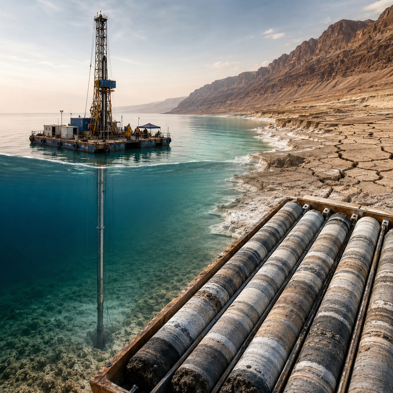
Dead Sea drilling reveals 450,000 years of droughts and water collapses, showing the region faced crises long before the current scenario.
In 2010–2011, the Dead Sea Deep Drilling Project, carried out under the International Continental Scientific Drilling Program with the participation of the Geological Survey of Israel, performed a rare operation in the Dead Sea, Israel: directly drilling the bottom of the hypersaline lake, at a point with about 300 meters of water depth, near the deepest area of the basin. According to the 2012 report by the Geological Survey of Israel, listed by the ICDP, the campaign took place between November 2010 and March 2011 and reached up to 459 meters below the lakebed at the deep site.
The result was the recovery of a sedimentary core of about 455 to 456 meters, preserving a high-resolution paleoclimatic archive of the environmental history of the Levant. The available database of the PaleoAsia project records that this core preserves about 220,000 years of paleoenvironmental and climatic history, while a study published in June 2022 in Quaternary Science Reviews describes the Dead Sea record as a detailed source on climate change and major variations in the regional water balance over the last 200,000 years.
The objective of the drilling was not only to reconstruct the remote past of the Dead Sea but to understand how one of the planet’s most arid and tectonically active regions responded to extreme cycles of drought, lake level rise, salt deposition, vegetation changes, and geological instability. By traversing successive layers of laminated mud, gypsum, and halite, scientists opened a direct window into the climatic history of the Eastern Mediterranean and how the hydrological system of the Levant reacted to abrupt changes long before the modern era.
-
Bosch Unveils Series 8 Dishwasher with Zeolith Drying, Voice Control, and Energy-Efficient Features

-
Brazilian Students Develop “Reminder Robot” to Help Seniors with Medication Management Using Arduino Technology

-
Canada Makes Historic Decision to Purchase New German Submarines in $70 Billion Defense Program, Replacing Aging Victoria-Class Fleet by 2033
-
4,000-Year-Old Stone Circle Discovered Near Belfast, Unveiling Prehistoric Ritual Complex in Irish Countryside


Sediments reveal repeated cycles of extreme droughts and lake collapses
The material collected from the bottom of the Dead Sea functions as a highly precise chronological record. Each sedimentary layer represents a specific period in the region’s climatic history, allowing for the identification of changes over hundreds of thousands of years.

The data show that the lake has already experienced multiple episodes of:
- Drastic reduction in water level
- Formation of thick salt layers
- Prolonged interruptions in the hydrological regime
At times, the system practically collapsed, with the lake shrinking drastically. These events indicate that extreme aridity is not a recent phenomenon but a recurrent process in the region’s history.
Salt and mud layers function as a “natural archive” of the climate
One of the most important aspects of the drilling is the alternation between sediment layers. When the climate was wetter, the lake received a larger volume of water and fine sediments, forming mud layers.
During periods of intense drought, evaporation exceeded water inflow, leading to salt deposition. This alternation creates a direct visual and chemical record of the oscillations between wet and arid periods.
Records show that prolonged droughts occurred long before the modern crisis
The data indicate that the Middle East region has already faced extremely prolonged droughts long before the current water crisis.

In some periods, water scarcity lasted thousands of years, completely altering the lake’s dynamics. This reinforces the idea that the local climate system is highly sensitive to natural variations.
The current difference lies in the combination of natural variability and human pressures on water resources.
Drilling also captured signs of ancient earthquakes
In addition to climate, the project also recorded tectonic activity. The Dead Sea is located on an active geological fault, part of the Dead Sea Transform system.
In the sediments, scientists identified deformed structures associated with ancient earthquakes. These records allow for the reconstruction of the frequency and intensity of seismic events over time.
The sedimentary core functions not only as a climate archive but also as a geological history of the region’s tectonic activity.
Operation required special platform for deepwater drilling
Drilling in the Dead Sea presented significant technical challenges. To access the lakebed, it was necessary to build a floating platform adapted to the extreme conditions of the region.

Among the challenges were:
- High water salinity
- Platform instability
- Need for continuous and precise drilling
Nevertheless, the operation managed to recover one of the most complete records ever obtained in a deep lacustrine environment. The complexity of the operation reflects the scientific value of the samples obtained.
Data helps understand the water future of one of the planet’s most critical regions
The Dead Sea today faces an accelerated drop in water level, caused mainly by the reduction of the Jordan River flow and the intensive use of water resources.
By analyzing the past, scientists can compare natural patterns with the current scenario. This allows for the identification of:
- Differences between natural and anthropogenic droughts
- System resilience limits
- Possible future trajectories
The past recorded at the bottom of the lake becomes a tool for predicting future risks.
Region combines climatic and human factors that intensify water scarcity
The current crisis in the Dead Sea cannot be explained solely by natural factors. Among the main elements are:
- Water diversion for agriculture
- Growing urban consumption
- Reduction of river flow
- Increased evaporation due to warming
This combination makes the situation more complex than historical events recorded in the sediments. The current water system faces pressures that did not exist in past periods.
Study reinforces vulnerability of arid regions to climate change
The project’s results show that arid regions are particularly sensitive to climate change. Small variations in precipitation can cause major changes in water balance.
In the case of the Dead Sea, this translates into significant changes in the lake level. This behavior makes similar regions highly vulnerable to future climate changes.

The project’s success demonstrates that it is possible to access deep records even in challenging environments. This paves the way for new initiatives in other lakes and sedimentary basins around the world.
These studies can broaden the understanding of climate, geology, and environmental evolution. Scientific drilling continues to be one of the main tools for investigating the planet’s history.
Given these records, what does the past of the Dead Sea reveal about the future of water in the region?
The drilled sediments show that the Dead Sea has already faced extreme cycles of drought and recovery over hundreds of thousands of years.
However, the current scenario adds a new layer of complexity, with strong human influence on the water system.
The question that arises is direct: if the lake has already naturally collapsed in the past, what can happen when climate change and intensive water use act together in the present?


