 Portuguese
  English
  Spanish
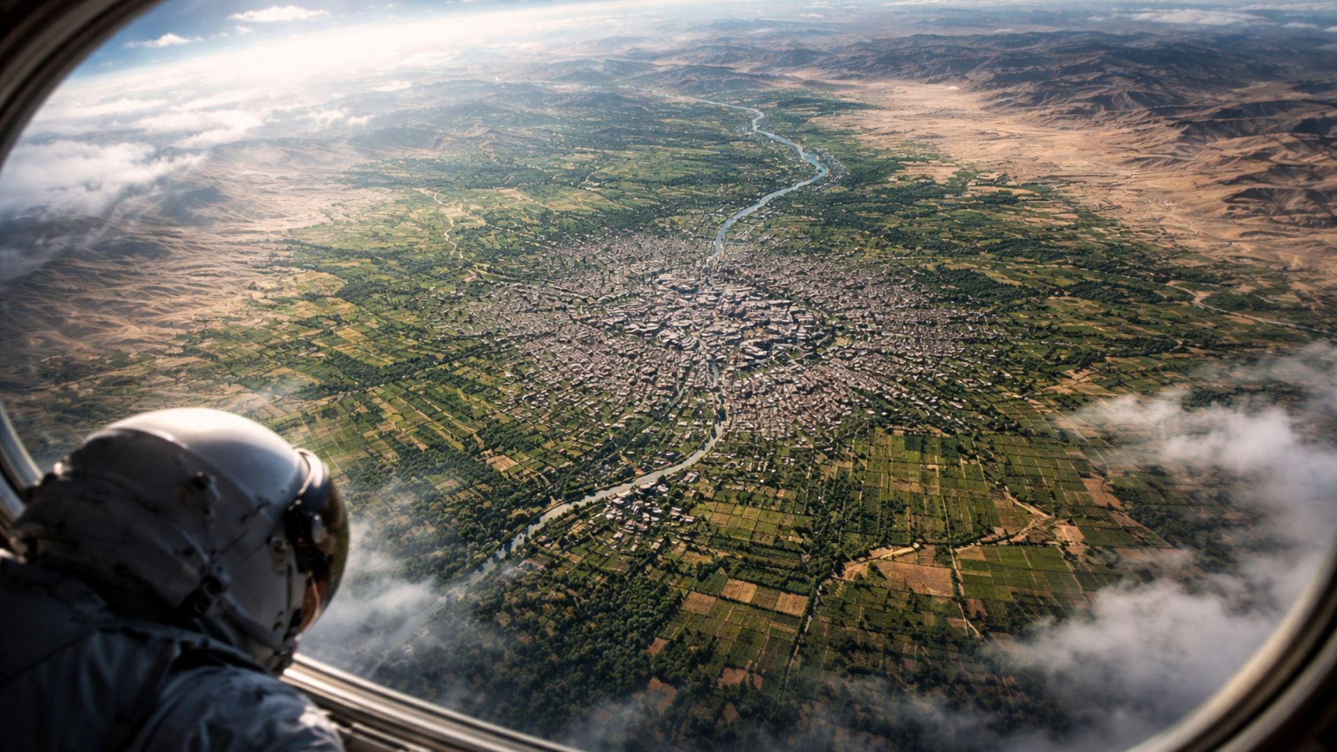
Orbital registration highlights the relationship between geography, agriculture, and history in Samarkand, revealing urban permanence in a strategic oasis of Central Asia and reinforcing historical importance linked to the Silk Road and the fertile valley of the Zerafshan River.
A photograph taken by an astronaut aboard the International Space Station has brought Samarkand back into the spotlight by showing, with unusual clarity, the Uzbek city located in the heart of a large oasis in Central Asia.
In the framing released by NASA, the urban area appears surrounded by cultivated surfaces in the valley of the Zerafshan River, a geographical combination that helps explain why the site has endured for centuries as a point of continuous occupation, agricultural production, and commercial circulation.
More than an impressive portrait seen from space, the image synthesizes factors that have shaped Samarkand’s trajectory since antiquity.
-
Man starts filling potholes on his own and mocks the city hall: “Pay me instead of taxes.” The action caught attention and drivers began to reward him with money and coffee.

-
A 1945 wine bottle is sold for over R$4 million and surprises the world by breaking a historical record at an international auction.

-
Croatia looks like a boomerang on the map and leaves Bosnia with only 20 km of sea, but compensates with 5,830 km of coastline, over 1,200 islands, and a giant bridge inaugurated in 2022.

-
World War II plane appears out of nowhere on a beach in the United Kingdom, becoming an attraction for tourists and locals and reigniting the story of the mysterious Maid of Harlech buried beneath the sea.

The presence of water, the fertility of the valley, and the strategic position between major axes of movement have favored human permanence and sustained a historical role that transcended regional borders.
When observing the city from above, what is seen is not just an urban blot surrounded by fields, but a territory that preserves, in its very landscape, marks of a long historical duration.
Samarkand in the valley of the Zerafshan and the strength of the agricultural oasis
According to NASA, Samarkand is situated in a large oasis within the valley of the Zerafshan, in southeastern Uzbekistan.
This fact is central to understanding the scene captured from space.
In a region associated with dry areas and great terrestrial distances, the city stands out precisely for occupying a more favorable environmental strip, where the availability of water and climatic conditions have made it possible to maintain extensive agriculture on the urban edges.
This visual contrast helps explain the interest sparked by the photograph.

Instead of the image of an isolated core amidst an arid environment, the record reveals a consolidated occupation linked to an agricultural matrix still visible.
The city appears integrated into productive areas that continue to organize the surrounding space, reinforcing the reading that the natural environment has not only served as a backdrop but as a material basis for its survival over time.
The space agency itself observes that the fields are especially noticeable in parts of the surroundings and that the current landscape still reflects favorable conditions described in historical accounts.
This data brings the past and present closer without resorting to idealizations.
What the orbital image objectively shows is the permanence of a territorial logic in which water, cultivation, and urban settlement remain deeply connected.
Silk Road and the Commercial Centrality of Samarkand
The relevance of Samarkand is also explained by the position it occupied on Euro-Asian trade routes.
NASA states that the city was one of the oldest and most important along the ancient Silk Road, a circulation system that connected different regions of Asia to Europe since at least around 200 B.C.
Historically, this centrality transformed the location into a transit point for goods, people, techniques, and cultural references.
In this context, Samarkand did not rely solely on the agricultural production of the valley to sustain its vitality.
The city thrived because it combined a stable territorial base with integration into long-range trade networks.
This dual condition, agricultural and commercial, helps to understand why the urban core maintained relevance even during periods of profound political and military changes in Central Asia.
The photograph reinforces this role by showing a city that did not appear fortuitously on the map.
Its intermediate location between East and West gave it historical density.
At the same time, the oasis and the fertile valley ensured the practical conditions for this strategic position to be converted into urban continuity, rather than resulting only in temporary occupations.
History of Samarkand: Conquests, Empires, and Reconstructions
According to NASA, Samarkand is considered a city founded around 700 B.C., placing it among the oldest urban centers in the region.
In its long trajectory, it has been associated with decisive episodes in the history of Eurasia.
Among them are the conquest by Alexander the Great in 329 B.C., the destruction linked to Genghis Khan’s invasion in 1220, and its transformation into the capital of Timur’s empire, or Tamerlane, starting in 1370.
The succession of these milestones shows that the importance of Samarkand has never been static. The city has gone through phases of conquest, decline, reconstruction, and new flourishing.

Nevertheless, it continued to occupy a strategic space, capable of being politically reactivated by different powers.
This aspect reinforces the weight of the local geography, but also reveals the historical capacity of the urban center to adapt to distinct circumstances without losing its regional relevance.
Later, the city also played a political role during the Soviet period. NASA records that Samarkand was the capital of the Uzbek Soviet Socialist Republic between 1925 and 1930.
Today, it remains the capital of the homonymous province and a regional administrative center, indicating that its importance is not limited to its monumental past or the imagery of the Silk Road.
UNESCO World Heritage and Preserved Cultural Legacy
The historical and cultural value of Samarkand received formal recognition when UNESCO included the city in the World Heritage List in 2001, under the designation “Samarkand – Crossroad of Cultures.”
In the official description of the organization, the historic city is presented as a crossroads of cultures of the world and as a great oasis in the Zerafshan valley, with more than two and a half millennia of history.
This recognition is not only due to the city’s ancient fame but to the preserved ensemble in its historical area.
UNESCO highlights monuments such as the Registan, the Bibi-Khanum Mosque, the Shakhi-Zinda complex, the Gur-Emir, and the Ulugh Beg Observatory, as well as the different urban layers that bear witness to successive stages of Central Asian history.
The heritage, in this case, lies both in the buildings and in the continuity of the urban fabric and the permanence of the occupied site.
Although the photograph taken of the space does not show the architectural details of these ensembles, it offers another key to interpretation. The image helps to understand why this heritage consolidated precisely there.
What is seen is the territorial support that allowed the city to withstand invasions, empires, regime changes, and economic transformations without disappearing from the historical map of the region.
NASA Image Reveals Multiple Layers of Interpretation
Images produced by astronauts often gain attention for bringing together, in a single frame, scales that rarely appear together.
In the case of Samarkand, this effect is even more evident. In the foreground, the urban grid and agricultural areas emerge.
At an intermediate scale, the oasis inscribed in the Zerafshan valley appears. In historical depth, the scene refers to a city that has remained relevant for more than two thousand years.
For this reason, the record goes beyond aesthetic appeal. The photograph serves as a visual synthesis of a lasting relationship between geography, economy, and history.
The fertile soil, the available water, and the position in the ancient trade network helped shape an urban space whose permanence remains legible from above, even after so many political and cultural changes.
The image was obtained on September 13, 2013, during Expedition 37, with a Nikon D3S camera equipped with a 400-millimeter lens.
Afterward, it underwent cropping, contrast enhancement, and lens artifact removal, procedures informed by NASA itself to facilitate the reading of the landscape.
The result is a record that transforms Samarkand into an eloquent example of how certain cities remain visible in history because they continue to be supported by territorial conditions that still help define their place.


Seja o primeiro a reagir!