
 Portuguese
  Spanish
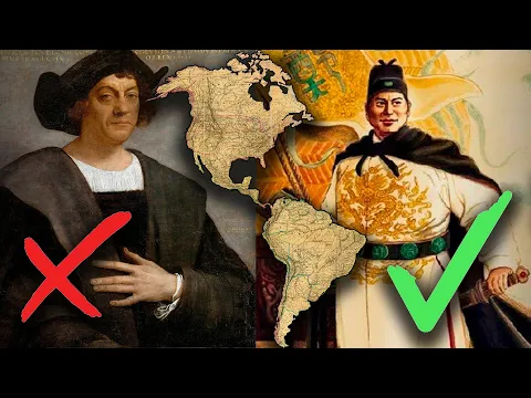
Detailed study points cartographic and technical evidence indicating Chinese global voyages in the 15th century, long before European expeditions dominated the historical narrative
Sino-American historian Sheng-Wei Wang has brought to light a revelation that could profoundly change the way we understand the history of global exploration. According to her research, the Kunyu Wanguo Quantu map, published in 1602, contains solid evidence that Ming dynasty navigators had already reached regions such as the Americas, Australia, New Zealand, and Africa decades before the famous European expeditions led by the Portuguese and Spaniards at the end of the 15th century.
In this sense, the research gains even more relevance by directly questioning one of the pillars of Western historiography: the idea that Christopher Columbus was the first to arrive in the Americas in 1492. Contrary to this, Wang argues that the geographical knowledge present in the Chinese map could only have been obtained through real voyages made long before this milestone.
The information was disclosed by the “South China Morning Post”, which highlighted the main points of the research and its possible global repercussions, especially in academic and historiographical circles.
-
Security Guard Becomes Doctor at Louisiana Hospital Where He Once Worked, Studied Chemistry Between Shifts

-
Woman Rescued from Luxury Complex in Brazil Worked Without Pay for 55 Years, May Be Entitled to Over $300,000

-
Brazilians in Portugal Face Increased Police Checks as Consulate Advises Carrying Documents; Long-term Resident and Tourist Report Heightened Scrutiny in Porto.

-
Russia Proposes Bold Energy Transition Plan at BRICS, Citing $8 Trillion Annual Cost for 2050 Global Target


15th Century Expeditions and the Strategic Role of Zheng He’s Voyages
Furthermore, Wang details that the evidence present in the map is directly linked to the great Chinese maritime expeditions of the early 15th century. These voyages occurred between 1405 and 1433 and were led by Admiral Zheng He, a historical figure known for commanding seven major oceanic expeditions during the height of the Ming dynasty.
According to the historian, the extremely precise latitude data recorded in the American portion of the map could not have been produced based on the European techniques available in the 16th century. On the contrary, this data indicates a much older and more sophisticated origin, possibly derived from measurements made during the 1420s and 1430s.
Another point that reinforces this theory is the presence of various toponyms — place names — in the Americas that do not appear on European maps from the same period. In other words, this discrepancy suggests that the Chinese had their own independent information about these territories.
Consequently, this analysis raises a powerful hypothesis: Zheng He’s expeditions may have gone far beyond the Indian Ocean, reaching territories previously considered unknown by Europeans.
Comparisons with European Maps Reveal Inconsistencies in the Traditional Narrative

In deepening her investigation, Wang compared the Kunyu Wanguo Quantu with various European maps from the 16th century. As a result, she identified dozens of significant differences, especially in geographic nomenclature and the accuracy of coordinates.
While the European maps of the time showed clear technical limitations, the Chinese map demonstrates a surprising level of detail. Thus, the researcher argues that this information cannot be explained as mere adaptations of Western models, but rather as a result of knowledge accumulated through direct exploration.
It is worth noting that the Kunyu Wanguo Quantu was produced from the collaboration between the Italian Jesuit Matteo Ricci and Chinese scholars such as Li Zhizao and Zhong Wentao, commissioned by Emperor Wanli. Still, Wang argues that the content of the map reflects a geographic reality much closer to the year 1433 — the date of Zheng He’s last major voyage — than to the European context of the 17th century.
Robust methodology and analysis of over 500 elements reinforce the thesis
To support her conclusions, Wang used an extremely detailed and technical approach. Her research involved the analysis of over 500 geographic elements present on the map, as well as dozens of textual annotations.
In parallel, this data was compared both with contemporary European maps and with historical Chinese records, including logbooks and official reports from the Ming dynasty. As a result, several correspondences were identified that reinforce the hypothesis of direct contact with distant regions.
Furthermore, the historian compiled her conclusions in the book Chinese Global Exploration in the Pre-Columbian Era: Evidence from an Ancient World Map, published in 2023, where she presents her thesis systematically and in depth.
Academic debate grows and challenges the so-called Age of Discoveries
On the other hand, despite the impact of the research, not all experts fully agree with the conclusions. Some scholars acknowledge the depth of the analysis and the richness of the data presented, but point out that maps alone would not be sufficient to prove continuous physical presence without additional archaeological evidence.
Still, the study already provokes an intense academic debate, especially as it confronts the dominant paradigm of the so-called Age of Discoveries, traditionally attributed to Europeans.
Historically, Chinese nautical capability has been underestimated by Western historiography. However, the expeditions led by Zheng He demonstrated an advanced technological level, with large vessels and open-sea navigation capabilities far beyond the Indian Ocean.
In this way, Wang’s research not only questions established versions of history but also proposes a broader revision of China’s role in the construction of global geographic knowledge.
Possible impacts may redefine global maritime history
Finally, if new evidence—such as historical documents that are still underexplored or archaeological discoveries—comes to confirm the presented hypotheses, the impact could be profound.
In this scenario, Ming dynasty China would no longer be seen as a peripheral observer and would take on a central position in the formation of the modern world. Consequently, a significant part of the historical prominence attributed to the West could be revised.
Thus, the Kunyu Wanguo Quantu solidifies as a strategic document, capable of condensing centuries of knowledge and opening new perspectives on the connections between continents since the 15th century.
Ultimately, Sheng-Wei Wang’s research reignites an essential debate: who really discovered the world as we know it today?


