Portuguese
  Spanish
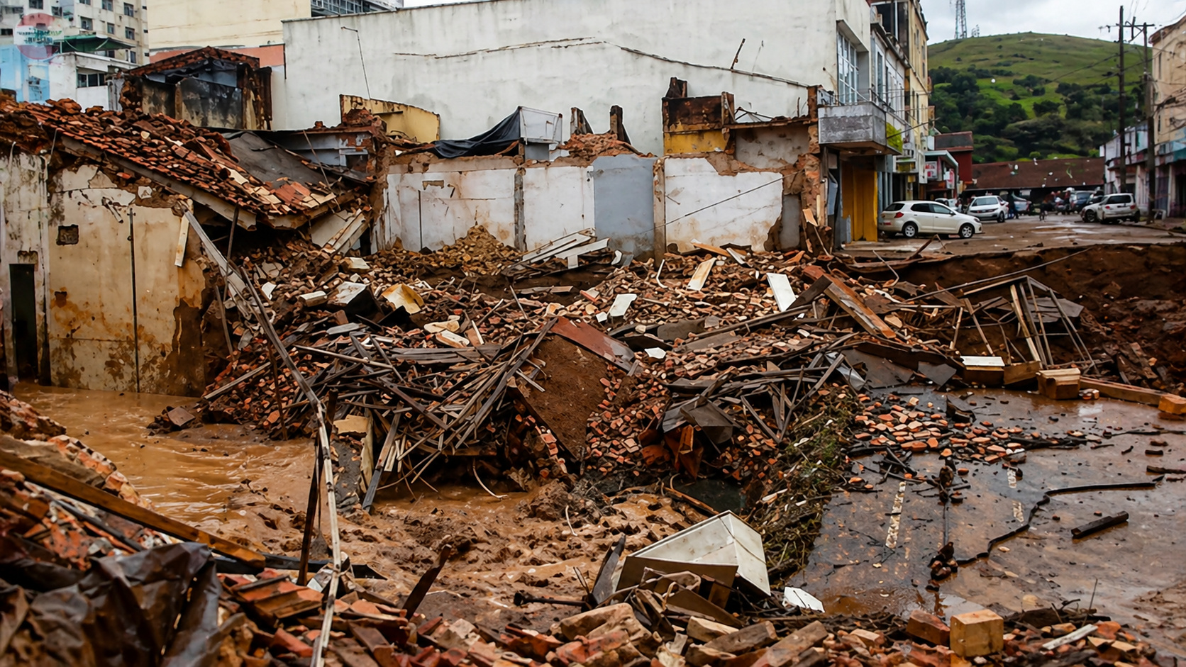
The advance of urban areas into risk zones shows that Brazil’s flood problem starts before the rain, grows with city occupation, pressures residents, and expands the alert for flooding in vulnerable regions, with 1.2 million hectares already exposed
The fastest-growing risk in Brazilian cities doesn’t only appear when it rains heavily. It has already advanced by 145% since 1985, occupies 1.2 million hectares, and could make floods and inundations an increasingly common threat.
The information was released by MapBiomas, a land use mapping initiative. Vulnerable urban areas increased from 493,000 hectares to 1.2 million hectares between 1985 and 2024.
This growth is concerning because the risk advanced faster than urbanization. In practice, this means that part of the cities grew in more sensitive areas, where water can occupy streets, homes, businesses, and circulation areas when the rain intensifies.
-
Real Estate Agent Buys Marvel Movie Subway Car for $5,000 and Converts It into Themed Airbnb
-
Real Estate Agent Buys Marvel Movie Subway Car for $5,000 and Converts It into Themed Airbnb
-
Former Roma and Fiorentina Player Filipe Gomes Returns to Brazil to Found Empório do Galeto, Aiming for $10 Million Revenue by 2026
-
Canada Builds 6.2-Hectare Containment Box to Trap 615,000 Cubic Meters of Toxic Sediment in Lake Ontario


The city grows, but the risk grows with it and appears when water takes over streets and homes
The advance of urban areas into risk zones reveals a problem that doesn’t just arise during a storm. It begins when the city occupies locations more exposed to floods, inundations, and waterlogging.
When these areas increase, rain encounters more obstacles and less space to follow its natural course. The result can appear as streets taken over by water, stalled traffic, affected homes, and residents without access to basic services.

The figure of 145% is striking because it shows a profound change in urban territory. Growth was not restricted to new streets and neighborhoods. It also reached vulnerable regions, where the risk to the population tends to be higher.
The jump from 493,000 hectares to 1.2 million hectares reveals a national alert
In 1985, Brazil had 493,000 hectares of vulnerable urban areas. In 2024, this total reached 1.2 million hectares. The difference shows how the problem has spread over nearly four decades.
This data is important because it helps explain why floods and inundations seem increasingly present in the news and people’s lives. The city grew, but the risk also occupied more space.
The alert becomes even stronger when observing that the risk advanced faster than total urbanization. In other words, it wasn’t just the city that grew. The part of the city in vulnerable areas grew at an even more concerning pace.
Flooding isn’t just excessive rain, it’s also a result of where the city was built
Many people associate flooding only with heavy rain. But the problem also involves where houses, streets, and neighborhoods were built. When occupation reaches areas near water paths, the risk increases.
These paths can be rivers, streams, natural channels, and areas where water usually drains. In simple terms, these are the places that help water exit after the rain.
When the city constricts these spaces, water can return to the streets. Therefore, floods and inundations do not depend solely on the volume of rain. They are also linked to how the city has grown.
MapBiomas detailed that urban risk advanced faster than urbanization
MapBiomas, a land use mapping initiative, detailed the central points of the survey and indicated that urban areas in vulnerable regions grew faster than total urbanization between 1985 and 2024.
The organization also featured a statement from Mayumi Hirye, one of the coordinators of urban area mapping. She stated: “The expansion of cities must be considered in the context of risk and climate change.”
The statement reinforces a simple message. Growing without considering the risk can leave more people exposed. When the city expands into vulnerable areas, the next heavy rain can cause greater damage.
The silent collapse of cities begins when risk becomes part of the routine
The term silent collapse helps to understand a problem that grows gradually. The city continues to function, new neighborhoods appear, streets are opened, and life goes on. But, when heavy rain comes, the hidden risk emerges.
This type of pressure affects the routine of those who live, work, and depend on urban services. A flood can impede travel, close businesses, harm schools, affect health centers, and leave families in difficult situations.
Therefore, the growth of 1.2 million hectares in vulnerable urban areas is not just an environmental data point. It is also a warning sign for urban planning, public safety, and quality of life in cities.
What this advance shows for those who live in Brazilian cities
The data shows that the risk is not distant. It can be in streets that flood frequently, neighborhoods near streams, low-lying regions, and areas where water takes a long time to drain.
For the average resident, the impact appears directly. Rain can turn into damage, fear, and wasted time. In many cases, the problem repeats because the city has already grown in places where water struggles to pass.
Urban expansion needs to consider this scenario. Without attention to vulnerable areas, floods and inundations tend to remain a constant threat in many urban centers.
The 145% increase in urban areas in risk zones between 1985 and 2024 shows that the problem of floods in Brazil cannot be resolved merely as a consequence of rain. The occupation of the territory also plays a role in this equation.
With 1.2 million hectares vulnerable, the country faces an alert that involves residents, public managers, and the future of cities.
In your opinion, is your city prepared to face heavy rains, or is the risk still ignored until the water arrives? Comment and share this publication.