
 Portuguese
  Spanish
The longest village in Poland, Zawoja, stretches for 18 km in a mountainous valley of Central Europe, with houses aligned along the road, narrow plots, and a connection with Babia Góra. The linear format shows how geography, agriculture, and culture shaped an unusual rural design near the border with Slovakia.
The longest village in Poland is Zawoja, a village that stretches for about 18 km in a mountainous valley of Central Europe and may require almost a whole day to be crossed on foot from one end to the other. The location is in the south of the country, near the border with Slovakia.
The feature was highlighted in a publication by 3 Seas Europe on November 12, 2022, which presented Zawoja as a curious example of a linear settlement. The format draws attention because the village follows the valley, the road, and the strips of land historically used by the residents.
Zawoja draws attention for its unusual format

Zawoja impresses not only by its size in area or by the mountainous landscape. What makes the village different is the way it stretches across the territory, following a much more horizontal logic than concentrated.
-
Employee buys a ticket that a customer left behind, discovers a million-dollar prize, tries to claim the fortune, is fired after 20 years, and ends up in a legal dispute with the company.

-
China returned almost 20 Brazilian ships with soybeans and is now back to buying from the USA, but stocks above 9 million tons raise suspicions of a political move, not a commercial necessity.

-
Japan will have a bullet train that levitates at 500 km/h and will cross 90% of the route through tunnels; the project promises trips in just 67 minutes but faces billion-dollar challenges and unprecedented environmental obstacles.
-
Few people know, but the smallest city in Rio holds a tunnel that was once the largest in the world, covering only 95.35 km², housing a railway work of 2,233 meters, and is also known for the historic title of the 4th best climate in the world.


While many villages grow around a square, church, or central nucleus, Zawoja spreads over an extensive layout. The feeling is of a community that follows the road and the valley, instead of organizing itself in a compact center.
Walking through the village can take almost a day
The 18 km extension helps explain why crossing Zawoja on foot can turn into a long walk. For those who travel the village from east to west, the distance approaches a route that many people would take in an entire day.
The curious thing is that the contrast appears when the crossing is made in the other direction. From north to south, the same village can be crossed in a few minutes, precisely because its width is much smaller than its length.
The longest village follows the logic of a street
The shape of Zawoja fits the type of settlement known as a linear village. In Polish, this pattern is called “ulicówka,” an expression associated with the idea of a street village.
In practice, the houses are aligned along a main road, with plots and usage areas extending behind them. This design creates a very visual rural landscape: dwellings in the front, road in the middle, and strips of land stretching to the back.
Mountains help explain the village’s design
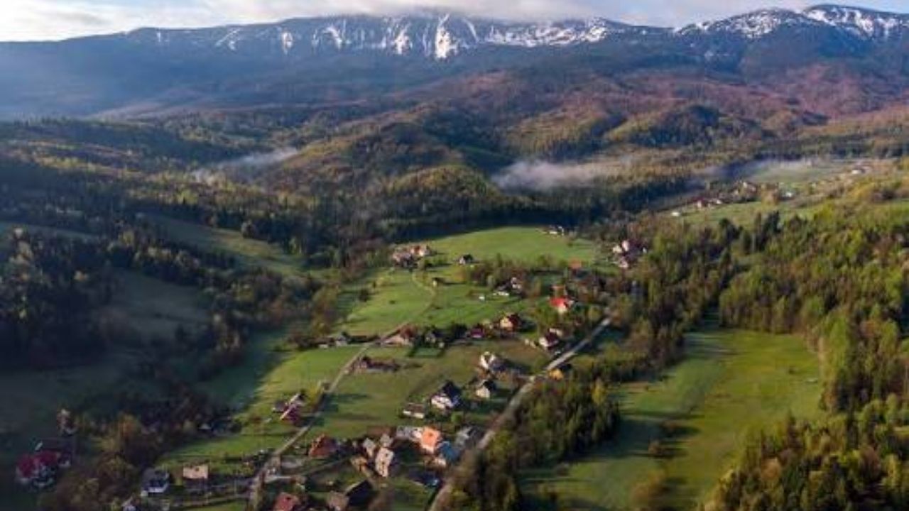
Geography plays a central role in this story. Zawoja is located in a mountainous region, and the valley conditioned the way human occupation spread across the territory.
In such areas, building and farming do not always allow for circular expansion. The terrain pushes the village into an elongated shape, following the most viable paths between slopes, arable lands, and local accesses.
Agriculture also shaped the occupation
Besides the terrain, land division helps explain why the village became so long. When each house faces the road, access to the land behind the dwelling becomes simpler and more organized.
This arrangement facilitates the identification of usage rights and agricultural work. Each family could have a direct connection between house, road, and strip of land, creating a practical logic for a rural community.
Houses, roads, and strips of land create the pattern
The design of Zawoja shows how the rural landscape can be the result of accumulated decisions over time. It is not just a cartographic curiosity but a form of occupation linked to survival, mobility, and work in the field.
The result is a village with a peculiar appearance. The houses seem to form a long sequence, while the road functions as the backbone of local life.
Zawoja is near Babia Góra
The region also attracts visitors for being close to Babia Góra, considered the highest mountain in Poland outside the Tatra massif. This makes the village a point of interest for hiking, nature, and mountain tourism.
The combination of unusual length and alpine landscape strengthens its tourist appeal. Zawoja is not just the longest village: it also serves as a gateway to one of the country’s most striking mountainous areas.
Mountain Culture Reinforces Local Identity
The area is linked to the culture of the Babiogórcy highlanders, an element that enhances the importance of Zawoja beyond its physical form. The village also carries history, customs, and a deep connection with the mountain environment.
This cultural aspect differentiates the visitor experience. Those who only see the 18 km miss part of the story: Zawoja is also a human landscape, built by generations around the valley.
Village is Long and Also Very Large in Area
Besides the 18 km in length, Zawoja has more than 100 km² of area, according to the source. This reinforces its position as one of the largest villages in Poland in territorial dimension.
Even so, physical size does not mean a population record. The village has about 7,700 inhabitants, a significant number, but smaller than other more populous Polish settlements.
Six Administrative Units Within a Village
Another curious detail is that Zawoja, alone, is composed of six “sołectwa”, the smallest rural administrative unit in Poland. Normally, a sołectwo can involve a village or even a group of villages.
This data shows the internal scale of the place. The longest village is not just an extended street: it functions as a rural territory divided into its own administrative parts.
Ochotnica Competes for the Curiosity of the Record
Zawoja faces a kind of curious competition when it comes to length. The village of Ochotnica, located in the Gorce mountains, could reach about 25 km, according to the source.
The difference is that Ochotnica has been divided into two separate villages since the 19th century: Upper Ochotnica and Lower Ochotnica. Therefore, Zawoja continues to be pointed out as the longest village in Poland in a single unit.
A Place That Looks Small on the Map, but Surprises on the Ground
On the map, a village may seem like just a dot. In Zawoja, however, the experience changes when you try to physically traverse the place, following the road and the valley for kilometers.
This difference between map and walk creates the impact of the story. The visitor realizes that the village is not large only on paper; it reveals itself step by step, curve by curve, house by house.
Rare rural format draws attention in Europe
The case of Zawoja is interesting because it shows a territorial organization uncommon for those used to compact cities or concentrated villages. The village behaves almost like a living line in the landscape.
This format transforms the local daily life. Internal distances, access to services, commuting, and perception of neighborhood are affected by a village that extends much more than it spreads.
Tourism born from landscape and curiosity

For travelers, Zawoja combines two attractions: mountainous nature and an unusual rural form. The village may interest both those seeking trails and those who enjoy places with curious geographical stories.
The experience is simple but striking. Walking through Zawoja is observing how terrain, road, houses, and fields can produce an urban-rural design that escapes the common pattern.
A village that became a path
The longest village in Poland shows how a community can grow differently when terrain, agriculture, and road define the pace of occupation. Zawoja stretches for 18 km between mountains and reveals one of the most curious rural formats in Central Europe.
More than a geographical curiosity, the village raises a question about how people occupy territory over time. Would you be willing to walk through an entire village for 18 km or would you prefer to explore Zawoja by car, stopping at the most beautiful spots? Share your opinion.


