 Portuguese
  English
  Spanish
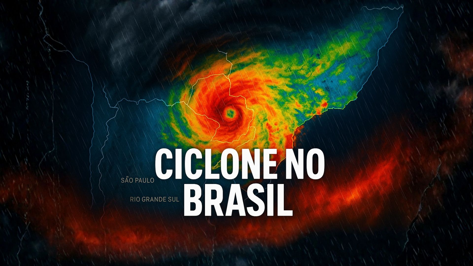
Intensification of an Extratropical Cyclone Triggers Storms, Winds Above 100 km/h, and Maximum Alert in Several Brazilian States.
A new extratropical cyclone is acting over southern Brazil this Tuesday (09) and is causing storms in much of the country, with heavy rain expected, hail, and wind gusts that can reach 120 km/h in areas of Rio Grande do Sul and Santa Catarina.
Meteorologists point to a critical scenario, especially between today and tomorrow, with rainfall accumulations close to the expected for the entire month in some cities.
As the system advances through Rio Grande do Sul, satellite images show heavy clouds spreading over the South, part of the Southeast, and areas of the Midwest.
-
The seemingly endless sand is disappearing: the world extracts 50 billion tons per year from rivers and beaches, a volume comparable to 19,000 pyramids of Giza, while mafias profit, islands disappear, and city concrete is threatened until 2050.

-
Rice in space becomes a scientific bet for China to understand how microgravity can alter the genetics of the most important grain for Asian food security and reveal if future generations of the plant can be born, grow, and maintain their biological identity away from Earth.

-
Bolivia requests a plane from the Lula government to distribute humanitarian aid amid protests, roadblocks, fuel shortages, and food scarcity in cities like La Paz.
-
Turkey is building a billion-dollar shortcut to channel billions of dollars by sea with a 45 km long canal, 275 meters wide and 20.75 meters deep, which promises to relieve the Bosphorus amid the crisis in the Strait of Hormuz.


The instability intensifies throughout the day, with storms and strong winds expected in several states, especially in the central-southern part of the country.
Extracropical Cyclone and Storm Alert in the South
The extratropical cyclone has already formed and is advancing through the gaucho territory, favoring the formation of clouds with significant vertical development.
They extend over Rio Grande do Sul, Santa Catarina, and Paraná, also reaching São Paulo and part of the Midwest.
According to information released live by the meteorology team, the National Institute of Meteorology (Inmet) issued a warning classified as “great danger”, a storm alert that covers almost the entire southern region.
The alert includes the risk of heavy rain, strong winds, and the possibility of hail.
In the coastal and mountainous areas of Santa Catarina and Rio Grande do Sul, gusts can reach around 120 km/h, according to meteorologists’ projections.
In various points in the south of the country, heavy rainfall is expected, with accumulations that can reach 120 millimeters this Tuesday, especially in southern gaucho, in the campaign, and along the coastline.
In Porto Alegre, the morning started with light rain interspersed with stronger wind gusts.
Reporter Gabriela Garcia, who is monitoring the situation on site, reported that the capital is experiencing constant instability, although without prolonged interruptions of rain.
According to her, “fortunately we have no reports of injuries,” but the material damages are significant in other municipalities in the state.
Damage in Flores da Cunha and the Serra Gaúcha
The most significant damage so far is concentrated in the Serra Gaúcha, especially in Flores da Cunha, identified by the state Civil Defense as the city most affected by Monday afternoon’s storm.
According to the agency, more than 2,000 people were impacted in the municipality.
At least 60 houses suffered some type of structural damage.
Part of a sports court in a recreational area was destroyed, as was the roof of a chapel and structures from three wineries in the region.
The storm also knocked down more than 20 vineyards, directly affecting grape production, in addition to impacting a school cafeteria and a hospital in the city.
Teams from the municipal and state Civil Defense remain on the ground to assess damages, distribute tarps to affected families, and assist in the temporary protection of damaged roofs and structures.
Despite the extent of the material damage, there are no reports of injuries, according to local authorities.
Technicians continue to monitor the advance of the cyclone and the behavior of rainfall throughout the day to guide the population on additional risks of flooding, roof collapses, and falling trees.
São Paulo Records Storm, Flooding, and Falling Trees
While the South faces the direct effects of the cyclone, the state of São Paulo also feels the influence of the system, with strong instability since Monday afternoon.
In the São Paulo capital, a storm with lightning and hail caused falling trees, flooding, and disruptions in various regions.
According to data from the Fire Department, from the start of the night to the early morning, there were 139 calls related to fallen trees.
There were also at least 22 flooding points on streets and avenues, in addition to one call for a landslide.
Cities in the Greater ABC region also suffered impacts.
In Santo André, two people were injured after part of a structure collapsed due to the force of the wind combined with heavy rain.
The victims received assistance after the incident, which highlighted authorities’ alerts about the destructive potential of gusts associated with the system.
Reporter Renan Fiúza, who is monitoring the situation in São Paulo, recalled that in the capital’s routine, episodes of heavy rain usually result in a recurring scenario of flooding and disruptions.
In his words, when it rains heavily, this “always becomes the tone in the city of São Paulo,” with falling trees, flooding points, and damage to structures.
Crisis Committee and Preventive Measures in São Paulo
In response to the continuing instability, the government of the state of São Paulo and the capital’s city hall have placed the Civil Defense structure on alert.
Agencies such as the Fire Department, the energy distribution company, and water supply companies like Sabesp, are part of a crisis committee formed to respond at least until Thursday.
The objective of this group is to monitor the forecast of heavy rain and gusts that can exceed 90 km/h, reaching about 100 km/h at times.
The joint coordination also seeks to expedite responses to occurrences such as falling trees, power outages, landslides, and new flooding.
Among the priorities are mobilizing teams on standby, monitoring risk areas, and direct communication with the population through alerts and safety recommendations.
Authorities emphasize that residents in flood-prone or landslide-susceptible areas should follow official guidance and contact Civil Defense in case of emergencies.
Tuesday and Wednesday Concentrate Highest Risk
Forecasts indicate that Tuesday and Wednesday will be the most critical days due to the passage of the extratropical cyclone.
The trend is for further intensification of areas of rain and strong winds, especially in the South and Southeast.
Meteorological maps indicate a band under extreme alert, highlighted in red, that extends from Rio Grande do Sul to interior São Paulo.
In these areas, the combination of heavy rain and intense gusts increases the risk of flooding, flash floods, landslides, falling trees, and damage to structures.
Areas in orange and yellow also have risk of heavy rain and localized storms throughout the day.
In some cities, it may rain almost the equivalent of the total expected for the entire month in just 24 or 48 hours.
In addition to intense precipitation, heavy rain with strong winds is expected today and tomorrow, with greater intensity on Wednesday.
States have active Civil Defense alerts, recommending that the population seek shelter in safe locations during storms and avoid areas prone to rapid flooding or overflowing streams.
Temperatures and Conditions in Other Regions
With overcast and unstable weather, temperatures are decreasing in much of the central-southern part of the country.
In Porto Alegre, São Paulo, and Curitiba, the expected maximum does not exceed the range of 22ºC to 23ºC.
Outside the area of greatest influence of the cyclone, the scenario is different.
In the Northeast, cities like Recife and Salvador are expected to see maximums around 31ºC, with more muggy weather.
In the North, Belém can reach 34ºC, while Cuiabá is forecasted to be around 26ºC, with heavier rain expected in the afternoon.
The sun shines more brightly in a band extending from Espírito Santo to the extreme north of the country, although with the possibility of isolated showers.
In another area, represented in light green on meteorological maps, rain occurs more frequently, but far from the storms predicted for the South and part of the Southeast.
In light of a cyclone scenario, storms, strong winds, and heat in other regions, how can each resident better prepare to follow the Civil Defense guidance and reduce risks to their own safety in the coming days?


-

-

2 people reacted to this.