Portuguese
  Spanish
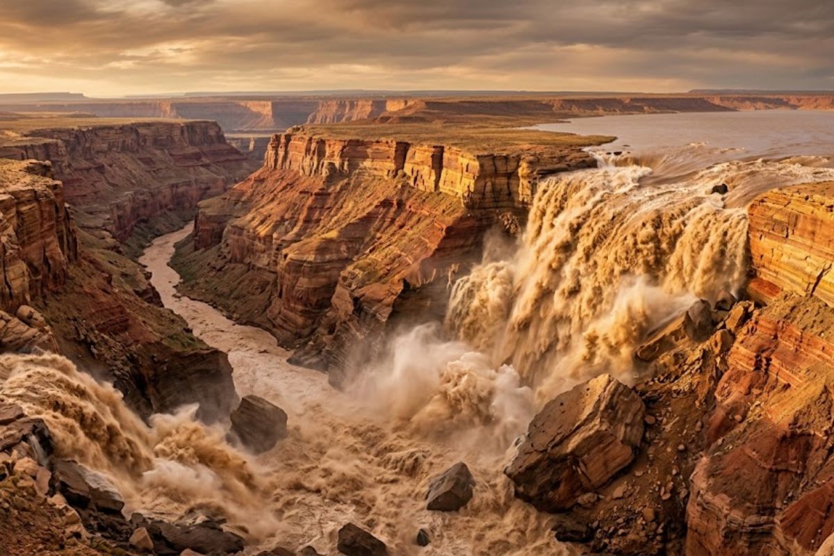
Published research in Science reconstructs the path of the Colorado River and demonstrates that the Grand Canyon began to be excavated after the overflow of Lake Bidahochi in Arizona, based on analysis of zircon grains and volcanic residues that function as geological records of the fluvial path through successive eras.
Geologists from UCLA and USGS published this week in Science a study that reconstructs the path of the Colorado River and reveals that the Grand Canyon began to take shape approximately 5.6 million years ago in Arizona, when a vast and shallow body of water called Lake Bidahochi accumulated volume beyond what it could retain and overflowed. To reach this conclusion, the team led by geologist John He examined zircon grains and residues of volcanic activity preserved in the deposits carried by the river, materials that serve as information capsules about the origin and the route taken by each mineral fragment. He described each zircon particle as a natural archive that records where it came from and where it has been.
The discovery resolves one of the most persistent gaps in geology. Although the existence of the Colorado River had been documented for at least 11 million years, no one had been able to determine which path it took before reaching the Grand Canyon area. Co-author Ryan Crow from USGS told Reuters that this question has finally been answered by sedimentary analysis. The data indicates that the Colorado River only penetrated the canyon region after Lake Bidahochi overflowed, then following through a succession of geological depressions until it flowed into the Gulf of California about 4.8 million years ago.
Lake Bidahochi: the missing reservoir that started it all

Before excavating the Grand Canyon, the Colorado River flowed into a depression located in northeastern Arizona that gradually transformed into a broad and shallow lake. This natural reservoir, which researchers named Lake Bidahochi, progressively accumulated water until the level exceeded the capacity of the basin and the liquid began to leak southwest. The flow that escaped inaugurated a route that the river had never taken before, passing exactly through the area where the Grand Canyon stands today.
-
He has never read a line of code, but he already knows how to work: the French company UMA presented in Paris the Northstar, its first AI-powered humanoid robot designed for factories and warehouses, capable of copying tasks just by observing an employee in action.

-
A young Kenyan engineer collects plastic waste from the streets and transforms it into robots that translate physics lessons into sign language in real-time, a machine made with old bottles that teaches what was missing to deaf children left out of science.

-
What is the dark substance found in the sand of Ipanema Beach? Civil Police conduct an examination, collect samples of the material, and initiate an investigation to identify the composition, clarify the origin, and verify if there was an environmental crime.
-
The beer that was hidden for 3,000 years has returned to the world: scientists find yeast preserved in Ancient Egyptian vessels and recreate a pharaoh’s drink to discover the lost taste of an ancient civilization.


The overflow of Lake Bidahochi was not a sudden event in human terms, but represented an irreversible geological turning point. From the moment the water found its way through the rocks of the region, the process of erosion became continuous and deepened the channel for millions of consecutive years. The vertical walls, the canyons, and the exposed layers that today define the landscape of the Grand Canyon are the direct result of this prolonged excavation, initiated by a lake that no longer exists.
What the zircon grains revealed about the course of the Colorado River

Zircon was the key piece that allowed scientists to accurately reconstruct the history. Each microscopic grain carries chemical information about the rock from which it was detached and about the distance it traveled before being deposited, which transforms the river sediments into a chronological map of the Colorado River’s path over eras. The team analyzed thousands of these particles collected from different points in the basin.
The residues of volcanic activity found in the same deposits served as an additional layer of confirmation. By cross-referencing the zircon data with volcanic marks, the researchers were able to establish that the Colorado River took its current course through the Grand Canyon only after the overflow of Lake Bidahochi. He, from UCLA, and Crow, from USGS, state that this combination of evidence offers, for the first time, a cohesive narrative that connects the vanished lake to the canyon that exists today. The article in Science presents this sequence as the most robust explanation ever produced for the formation of the canyon.
Why the Grand Canyon only began to be carved 5.6 million years ago
The answer lies in the river’s route. Before the overflow, the Colorado River simply did not pass through the area where the Grand Canyon is located, and therefore there was no erosive force acting on those rocks. Lake Bidahochi acted as a kind of natural dam that, when it gave way, redirected the water along an unprecedented path. Without this event, the rock formations of Arizona would remain intact.
He stated to Reuters that the discussion about when the Grand Canyon was carved has been ongoing for generations within the geological community. The study published in Science contributes to this conversation by providing material evidence, extracted from zircon and volcanic deposits, that anchors the beginning of the excavation in a precise time frame. After reaching the Grand Canyon, the Colorado River continued its advance and reached the Gulf of California around 4.8 million years ago, completing the route it maintains to this day.
Water as a sculptor of landscapes: what the Grand Canyon teaches
The authors conclude the research with a reflection that transcends the canyon itself. The Grand Canyon demonstrates that water, even flowing in an apparently modest manner, has enough power to reshape entire terrains when given geological time. The process that began with the overflow of a shallow lake in Arizona produced, in a few million years, one of the most visited and studied formations on the planet.
The exposed rock layers on the walls of the Grand Canyon function as an open book of Earth’s geological history. The research in Science adds a fundamental chapter to this book by demonstrating, with evidence from zircon and sediments, how the Colorado River got there and why it began to carve. Lake Bidahochi no longer exists on any map, but its role as a trigger for one of the world’s most iconic landscapes has been forever recorded in the mineral grains that scientists have finally learned to read.
And you, did you imagine that the Grand Canyon was born because of an overflowing lake? Which geological formation impresses you the most? Leave your opinion in the comments.