Portuguese
  Spanish
Rio City Hall uses drones, artificial intelligence, and native seeds of the Atlantic Forest in degraded areas, in a strategy that combines environmental technology, urban reforestation, and long-term monitoring.
The advancement of solutions based on drones, artificial intelligence, and satellite monitoring has led cities to test new ways of recovering green areas amidst the increase of extreme climate events.
In Rio de Janeiro, this combination has become part of the municipal reforestation actions on slopes and terrains of difficult access.
The Rio City Hall began using seeding drones to launch native seeds of the Atlantic Forest in degraded areas, within a strategy that seeks to expand urban green coverage and support climate adaptation measures.
-
Abandoned Building in Brazil to Become Biotechnology Unit with $10 Million Investment, Bridging Science, Industry, and Public Health

-
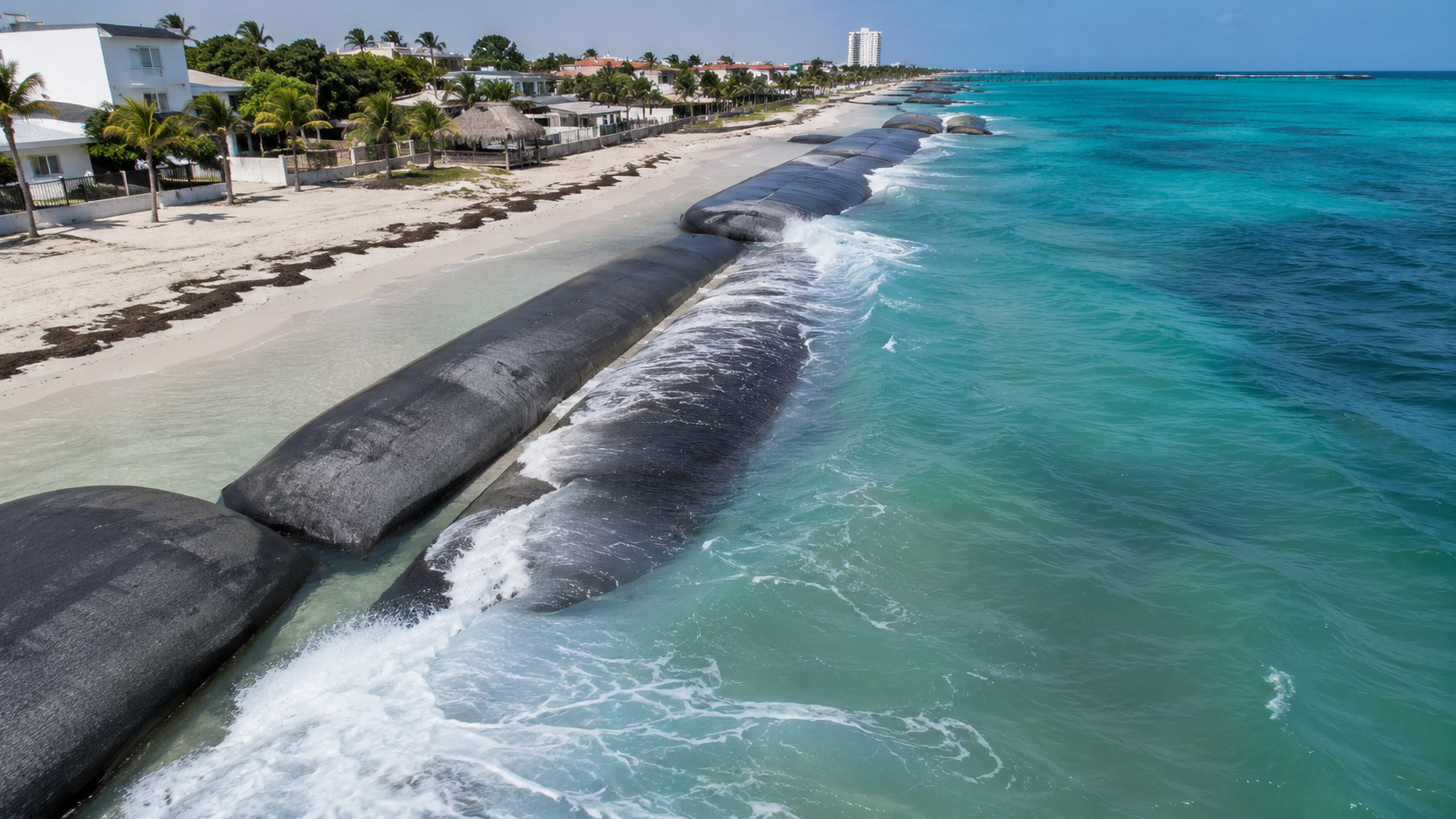
Netherlands Builds Giant 240-Meter Inflatable Barrier That Rises to Protect Cities from Storm Surges

-
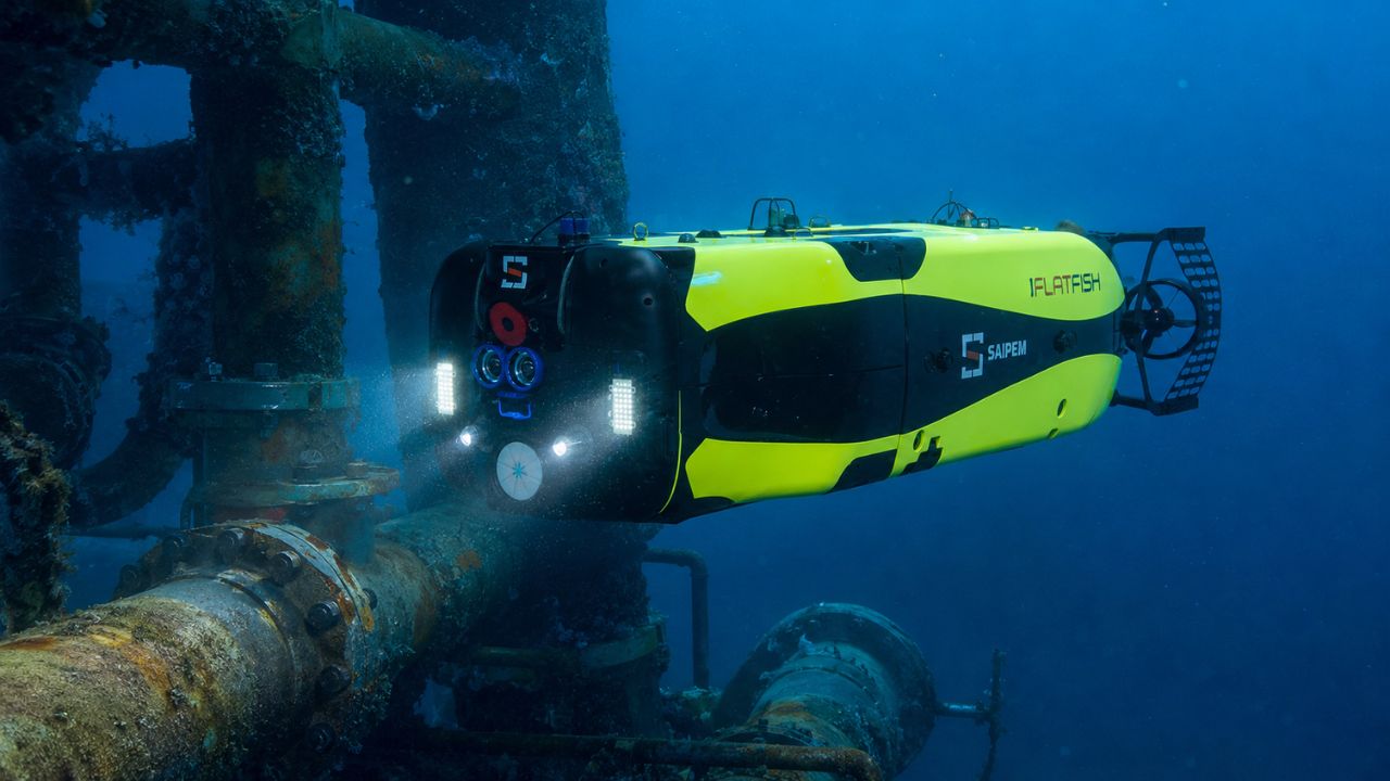
Brazilian Submarine Robot “FlatFish” Operates Independently at 3,000 Meters Depth to Inspect Seafloor Pipelines Without Support Vessels
-
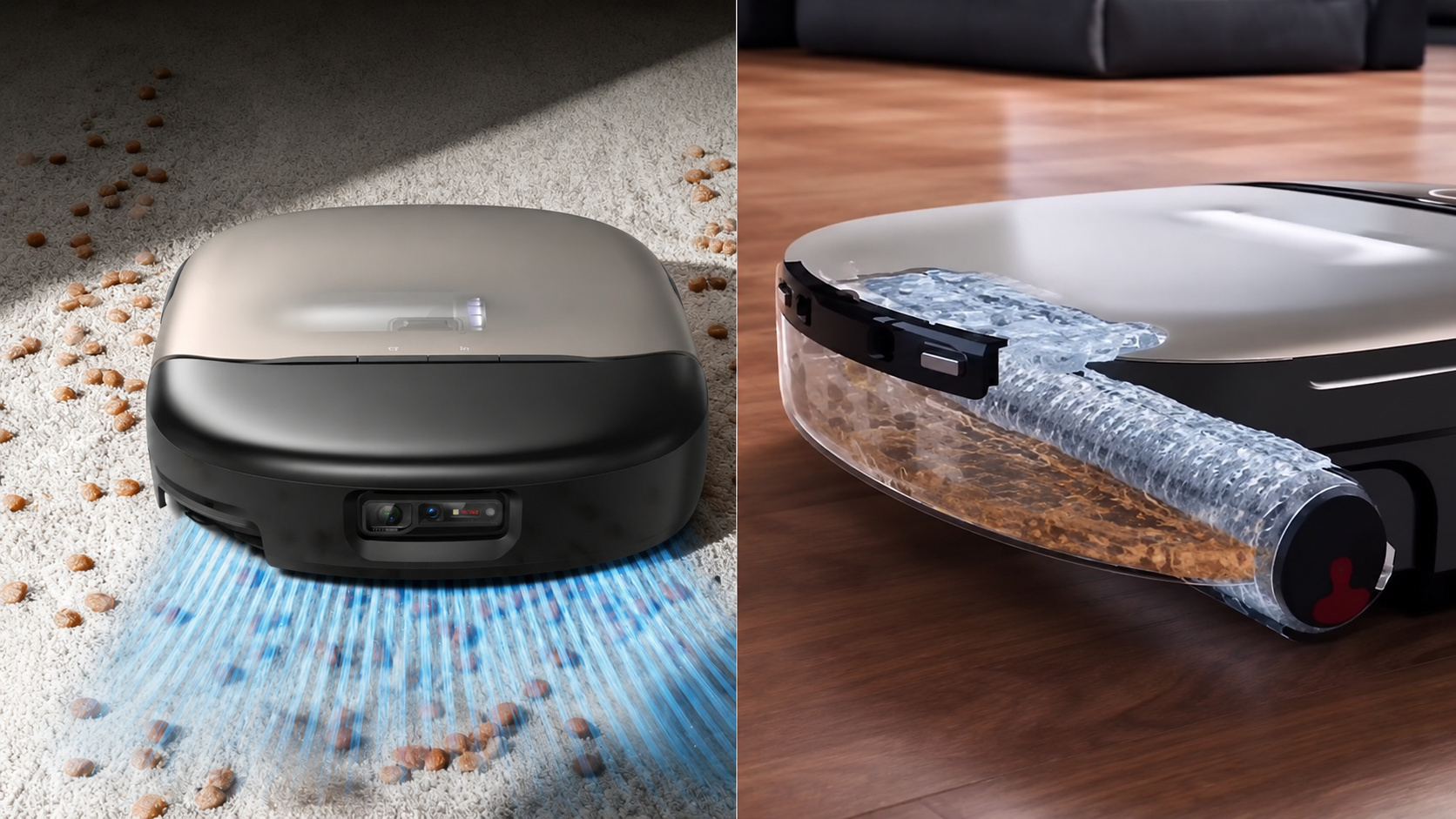
Eufy Unveils Omni S2: Advanced Robot Vacuum with 30,000 Pa Suction, Self-Cleaning Mop, AI Obstacle Avoidance, 12-in-1 Station, and Built-In Fragrance Dispenser


The technology was presented on January 5, 2024, at Mirante do Pedrão, in Botafogo, and had its first operational action on July 5 of the same year, in Serra de Inhoaíba, in Campo Grande.
Seeding drones in Rio’s reforestation
The use of drones to launch seeds on slopes and degraded areas has become part of Rio City Hall’s strategy to expand urban reforestation actions in regions where manual planting faces limitations of access, cost, and safety.
The initiative brings together satellite images, artificial intelligence, soil diagnosis, and aerial dispersion of native seeds of the Atlantic Forest, focusing on areas of difficult access in the West Zone of the city.
The technology was presented during a demonstration at Mirante do Pedrão, in Botafogo, within the Parque Maciço da Preguiça.
On the occasion, Mayor Eduardo Paes and the Municipal Secretary of Environment and Climate, Tainá de Paula, accompanied the equipment’s flight.
According to the City Hall, the pilot project would be implemented in the Floresta da Posse, in Campo Grande, within actions related to the response to heatwaves and the expansion of green coverage in the municipality.
The proposal had a practical stage on July 5, 2024, when the Municipal Secretariat of Environment and Climate carried out the first reforestation action with seeding drones in the Serra de Inhoaíba, in Campo Grande.
According to Rio City Hall, the action foresees the restoration of 30 hectares in the following three years and enrichment with native species in another 30 hectares.
Morfo Technology in Seed Planting
The operation uses technology from the French-Brazilian greentech Morfo, a partner of the municipality in the project.
The company works with mapping degraded areas, selecting species, preparing seeds, and subsequent vegetation monitoring.
According to the model presented by the City Hall, the drone is used not only for seed dispersal but also as part of an ecological restoration system accompanied by data.
The initiative’s goal is to deliver seeds to locations where field teams have difficulty reaching.
On steep slopes, isolated areas, or terrains with limited access, traditional work requires worker displacement, seedling transport, and more complex logistical preparation.
With the drone, dispersion occurs from a previously defined flight plan, which reduces the time teams spend in difficult-to-operate areas, according to the City Hall.
“With the use of drone technology, we will be able to expand the city’s green areas and thus mitigate the strong heat waves, as well as make Rio de Janeiro even more beautiful,” said Eduardo Paes during the initiative’s announcement, according to material released by the City Hall.
Tainá de Paula also linked the project to the ability to monitor reforested areas.
“With the drone, we take responsibility for more green areas. But we also start a process using artificial intelligence to track and monitor our seedlings and seeds. In addition to speeding up the process of our reforestation task forces,” said the secretary, according to the City Hall.
How Drone Planting Works
Before the flight, the first step is diagnosing the area, done with satellite and drone images.
This survey identifies the topography, water resources, existing vegetation, the presence of invasive species, and the general condition of the terrain.
In the laboratory, characteristics such as compaction, moisture, and the mineral and organic composition of the soil can also be evaluated.
Based on this data, teams determine which species have the best chance of germinating and developing in that environment.
The selection combines plants from different stages of ecological succession, including ground cover, shrub, and tree species.
According to the model described by the City Hall and Morfo, this combination aims to bring planting closer to a regeneration dynamic with plant diversity.
With the chosen species, artificial intelligence assists in designing the planting plan.
The system calculates which seeds should be dispersed in each area, in what proportion, and in which combinations.
Part of them can be used raw, while another part receives capsules with nutrients to improve the conditions of fixation and germination in the soil, according to the methodology presented in the project.
The dispersion is carried out by a small team, with two people and a drone.
Information released by the City Hall and reproduced by Agência Brasil indicates that the technology allows for faster planting compared to traditional methods, especially in areas where human access is limited.
Monitoring of Reforested Areas
The work does not end when the seeds reach the soil.
The next stage involves monitoring with updated satellite and drone images, as well as data analysis on vegetation cover, biodiversity, and carbon stock in the restored areas.
The City Hall reported that this information should feed a monitoring platform to guide project management.
The adoption of drones is connected to a reforestation policy initiated in Rio back in the 1980s.
Refloresta Rio derives from the Reforestation Task Force, a program created to recover slopes, areas near communities, and degraded sections of the city.
According to the City Hall, the program has already surpassed the mark of 10 million seedlings planted and reached an area equivalent to 3,600 football fields recovered.
Urban Reforestation and Climate Adaptation
In recent years, the recovery of green areas has also been treated by the municipality as part of climate adaptation actions.
The City Hall associates the expansion of vegetation with the reduction of heat islands, the protection of slopes, the infiltration of water into the soil, and the expansion of ecological corridors.
In Rio, this debate appears in public policies aimed at mitigating the effects of high temperatures and preserving areas of the Atlantic Forest.
The Posse Forest and the Inhoaíba Mountain Range were included in this context as areas for the application of drone seeding technology.
The City Hall states that actions in these regions aim to recover vegetation cover, protect springs, and reinforce the presence of native species.
The use of the equipment also allows testing a model that can be evaluated for potential application in other parts of the city, according to the results of plant germination and survival.
In ecological restoration projects, seed dispersion is just one of the stages of the process.
The methodology presented by the City Hall itself includes soil analysis, species selection, invasive species control, and continuous monitoring of the planted areas.
These factors are used to monitor whether the seeds can establish themselves and form vegetation cover over time.
In the case of Rio, the initiative combines an existing municipal reforestation program with remote sensing tools, automation, and data analysis.
The declared intention of the municipality is to gain scale in areas where manual recomposition faces more obstacles.
It remains to monitor, through monitoring data, what the performance of the areas seeded by drones will be in the coming years and whether the technology can expand the restoration of urban forests in other regions.