Portuguese
  Spanish
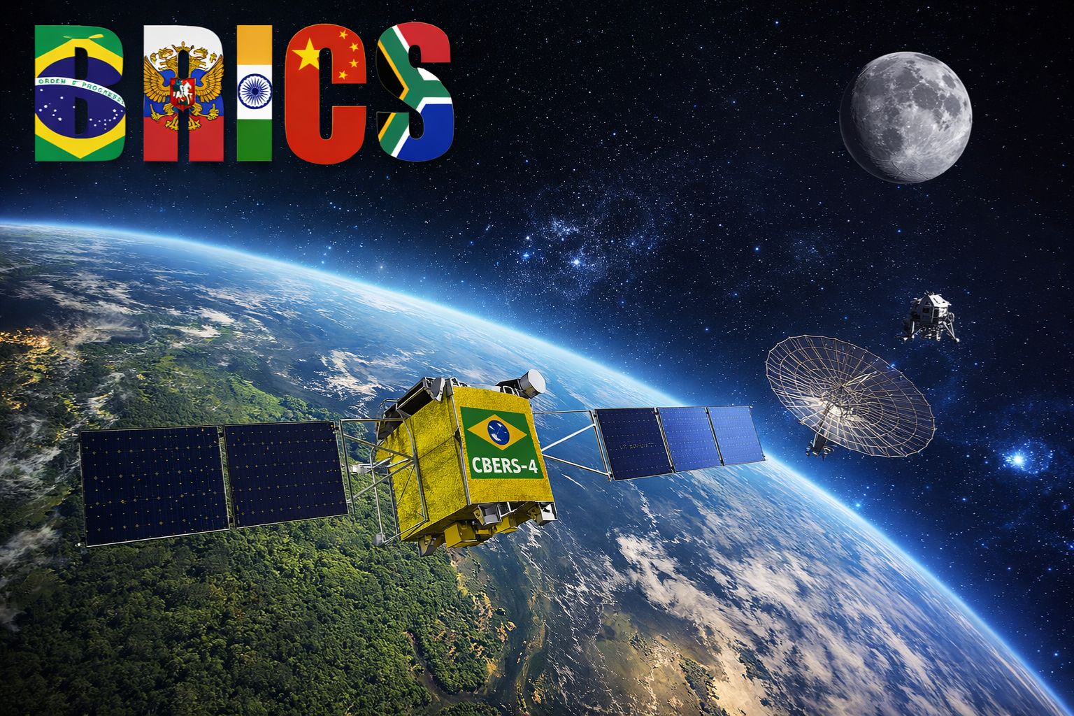
The BRICS satellite constellation covered more than 27 million km² and exchanged 1.5 terabytes of climate data in one year of operation, using six satellites from Brazil, China, Russia, and India. The bloc is now creating a Space Council, planning radar for the Amazon with the CBERS-6, and discussing lunar missions scheduled for the coming years.
The BRICS is building a space network that operates independently of Western agencies or companies, and Brazil is an active part of this structure. The bloc’s cooperative remote sensing satellite constellation has operated continuously over the past year and has already covered more than 27 million square kilometers, exchanging 1.5 terabytes of climate data among member countries. The system includes six operational satellites: two Chinese (Gaofen-6 and Ziyuan-III-02), the CBERS-4 (a partnership between Brazil and China), the Russian Kanopus-V, and the Indian Resourcesat-2 and 2A, forming a constellation that provides BRICS with autonomous capacity for environmental monitoring, disaster prevention, and territorial planning on a continental scale.
Commitments go beyond monitoring. Between April 27 and 29, 2025, in Brasília, BRICS Plus formalized new agreements for the peaceful use of space with a socio-environmental focus and digital sovereignty, expanding the responsibilities of national space agencies for regular cooperation. The bloc plans to create a Space Council at the Rio Summit, scheduled for July 2025, in addition to developing the CBERS-6 with radar to monitor the Amazon, launching the SABIA-Mar satellite for water resource management, and coordinating shared lunar missions. BRICS is taking seriously the idea that technological sovereignty begins in space.
What the BRICS satellite constellation has delivered in one year
According to information from the portal elciudadano, the operation numbers are concrete. In the year that the constellation began to produce and share data continuously, China sent 1.5 terabytes of images, mapped 560,000 km² for Russia, and the Russian space agency Roscosmos transferred data from 34,500 km² to India after an earthquake, demonstrating that the network works for both routine monitoring and emergency response. The ability to exchange information in almost real-time between five ground stations spread across three continents is what sets this constellation apart from smaller initiatives.
-
A fossil kept for years in a small museum in Montreal concealed 450-million-year-old soft tissue, a discovery that has only happened once before in history.

-
Three teenagers transform cut cardboard into Japanese origami-style packaging that promises to retire styrofoam and bubble wrap, win a $12,500 prize, and target giants like Amazon, FedEx, and Home Depot after a robot motor arrived broken.

-
The large jar blender has a rival: Oster Ultra Power bets on 1,000 W, six stainless steel blades, and two portable cups with leak-proof lids.

-
Tesla injected an additional $250 million into the German factory, doubled the battery cell target, and opened its own production line for startups.


The ground stations that support the BRICS network are located in Cuiabá (Brazil), Shadnagar-Hyderabad (India), Sanya (China), Hartebeesthoek (South Africa), and Moscow (Russia). These facilities work together for the reception, processing, and distribution of images captured by the six satellites, creating a global coverage system that does not depend on the infrastructure of American or European companies. For BRICS, this autonomy is not a luxury: it is a matter of strategic security that ensures access to sensitive data without intermediaries that could restrict supply for political reasons.
The Space Council that BRICS wants to create at the Rio Summit
The next institutional step for BRICS in space is the creation of a formalized Space Council. The proposal, contained in the so-called Rio Declaration, is to be established during the Summit scheduled for July 6 and 7, 2025 and would represent the first permanent structure dedicated to coordinating joint space programs within the bloc. The Council would have the authority to establish common standards, create shared institutions, and coordinate everything from climate monitoring to lunar missions.
The formalization of a BRICS space council elevates cooperation from a technical level to a political-strategic level. Instead of ad-hoc bilateral agreements between agencies, the bloc would have a central body capable of setting priorities, allocating resources, and negotiating with other space powers as a unified bloc. For Brazil, whose space agency INPE has a limited budget compared to those of China or India, participating in a multilateral structure expands access to technologies and data that would be unattainable in isolation.
What BRICS plans for the Amazon with radar and new satellites

Two BRICS initiatives have the Amazon as a direct strategic target. The CBERS-6, a radar satellite developed in partnership between Brazil and China, is scheduled to operate in 2028 and will have applications in monitoring droughts and deforestation, overcoming a limitation of current optical satellites that cannot capture images through the cloud cover that blankets the Amazon region for much of the year. The radar penetrates the clouds and delivers images regardless of weather conditions.
The SABIA-Mar, focused on water resource management, is expected to be launched in 2026 and complements the CBERS-6 by focusing on oceanographic and coastal data. Together, the two satellites will provide Brazil and BRICS with environmental monitoring capabilities that cover everything from the tropical rainforest to the oceans, integrating information that is essential for policies to combat deforestation, manage watersheds, and respond to natural disasters. The fact that both are projects developed within the BRICS framework reinforces the idea that the bloc is prioritizing practical applications that generate direct returns for its members.
The lunar missions and the educational program that BRICS is preparing
The space ambition of BRICS is not limited to Earth’s orbit. The Rio Declaration should include coordination of shared lunar missions and deep space research, putting the bloc on a collision course with the United States’ Artemis program and consolidating the International Lunar Research Station promoted by China as an alternative to the Western model of lunar exploration.
In parallel with technological missions, BRICS invests in human training. The Mission ShakthiSAT program will bring together 12,000 female students from 108 countries in a global science and technology (STEM) course, with one student from each nation invited for practical training at the Indian space agency ISRO. The launch of orbital or lunar payload is scheduled for 2026 as part of the program. The initiative demonstrates that BRICS views space not only as a technological domain but as a tool for educational inclusion and projection of soft power.
What BRICS in space means for Brazil and technological sovereignty
For Brazil, active participation in BRICS’s space network represents a strategic leap that the country could not achieve alone. Independent climate data strengthens local environmental policies, the CBERS-6 radar will provide continuous monitoring of the Amazon without relying on foreign satellites, and access to technologies from partners like China and India accelerates the development of the national space industry. The ground station in Cuiabá positions Brazil as an essential operational node of the constellation, not merely as a beneficiary.
Challenges persist: disparities in technological capacity among agencies, insufficient public funding, and barriers to technology transfer. However, the shared satellite constellation of BRICS already functions as a concrete instrument of technological sovereignty and south-south cooperation, paving the way for reduced external dependence. When the Space Council is formalized and the new satellites come into operation, the bloc will have built a space infrastructure that rivals the functionality of traditional powers, and Brazil will be part of this structure as a founding member.
BRICS has already mapped 27 million km² with its own satellites and is now planning radar for the Amazon and lunar missions. Did you know that Brazil participates with a satellite in this network? Do you think the country should invest more in space? Leave your opinion in the comments.