 Portuguese
  English
  Spanish
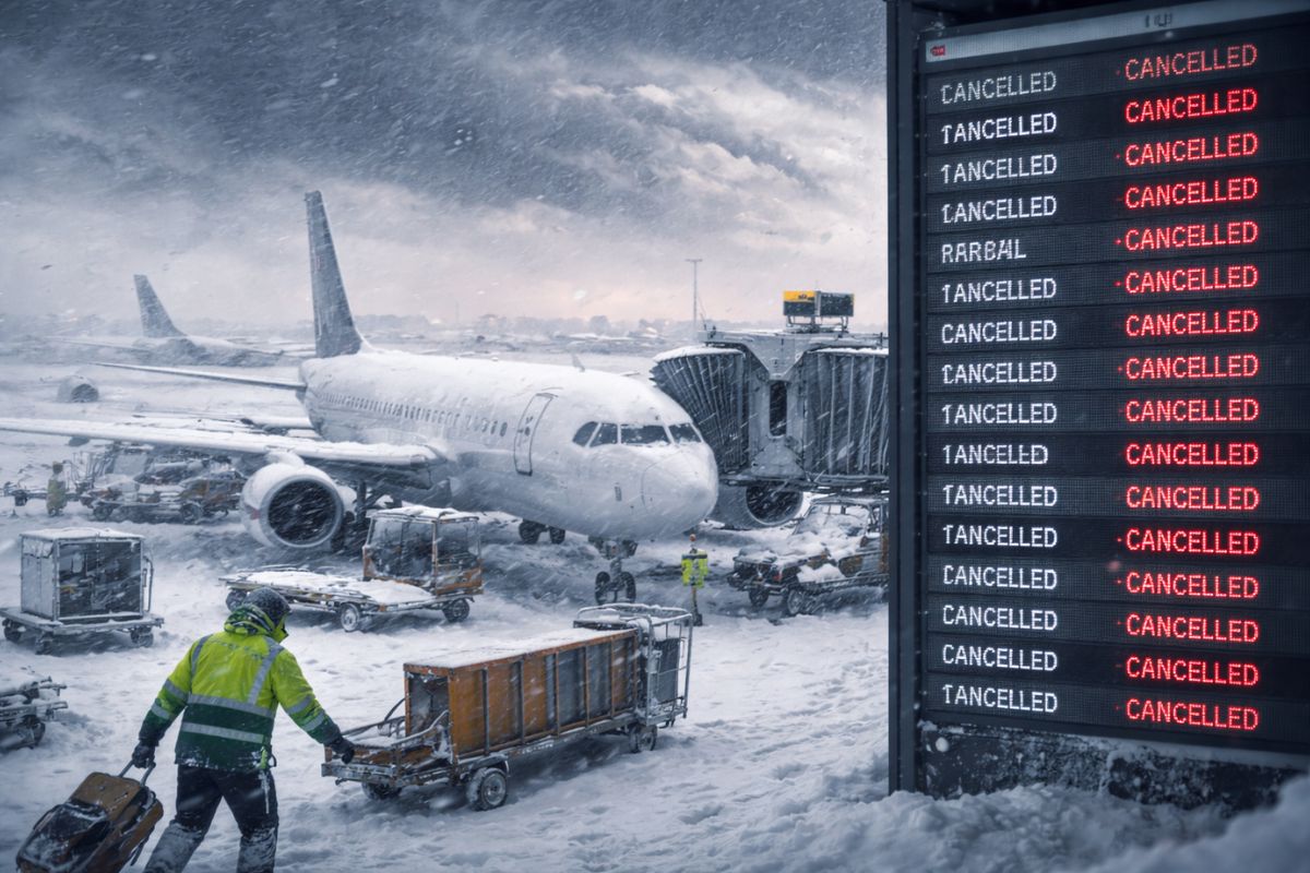
The Bomb Cyclone Advances Since Sunday, Spreading Intense Blizzard and Gusts Comparable to Hurricane in Several States, Elevates Risk on Roads, Takes Down Power, Pressures Airports in New York and Boston and Places Almost 60 Million Residents Under Meteorological Alerts in the United States Amid a Regional Escalation.
The bomb cyclone hitting the United States since Sunday, February 22, has entered the radar of international media as a major impact event for combining heavy snow, very strong winds, and simultaneous effects on mobility, energy, and aviation. The picture described by meteorological services and vehicles cited in the base shows a storm with broad reach and immediate consequences on various fronts.
This Monday, February 23, the most striking records included gusts of up to 135 km/h in Montauk Point, New York, as well as significant snow accumulation in urban and suburban areas of the northeastern United States. At the same time, the system pressured airports, affected the routine of millions of people, and kept a significant portion of the population under alert.
Snow, Wind, and Impact Scale Put the Phenomenon in Another Level
The combination observed in this episode helps explain why the bomb cyclone is being treated as historic.
-
For the first time in history, a submarine cable will descend to four thousand meters deep under the ice of the North Pole to ensure that the internet between Europe and Asia no longer depends on conflict zones in the Middle East.

-
A British company has installed in the middle of the ocean the world’s first floating platform that generates electricity 24 hours a day from the temperature difference between the surface and the depths of the Atlantic, without relying on wind or sun.
-
The James Webb telescope spotted a planet 700 light-years from Earth with mornings full of sand clouds and nights with clear skies, the temperature difference between the two hemispheres reaches an impressive 170 degrees.
-
A former Hong Kong police officer has just become the first astronaut from her city to go to space. She embarked on the Shenzhou-23 mission alongside two other colleagues who will face muscle atrophy, radiation, and prolonged fatigue in orbit.


According to the information provided, the system combines winds comparable to those of a hurricane and large volumes of snow across various states, which elevates the risk at the same time in urban centers, highways, power grids, and air terminals.
The accumulation data show the magnitude of the event. At 7 AM Eastern Time, Central Park had about 38 centimeters of snow, while Newark recorded 46 centimeters.
In Massachusetts, the accumulation reached 67 centimeters this Monday, reinforcing the severe nature of the storm in different points of the Northeast.
Where the Storm Hit Hardest and How Alerts Spread
Besides New York and Massachusetts, the base cites impacts in Connecticut, Delaware, New Jersey, and Rhode Island, indicating that the bomb cyclone was not confined to a single corridor.
The regional effect is one of the central elements of this coverage, as it expands the number of areas under monitoring and complicates the operational response of transportation and services.
In total, almost 60 million residents in the affected areas were under meteorological alerts.
At the same time, over 250,000 people were without electricity since the arrival of the phenomenon. This data is crucial, as it shows that the crisis is not limited to the discomfort caused by snow, but also affects basic infrastructure and domestic safety.
Airports Collapse and Flight Crisis Becomes a National Effect
The most visible impact for those following movements was in aviation.
According to the cited numbers, the bad weather has already caused more than 5,500 flight cancellations across the country, plus another 9,000 delays, which turns a regional storm into a logistical problem of national scope.
New York and Boston accounted for the highest number of cancellations and delays, which was expected given the intensity of the snow and winds in the Northeast.
When the main hubs in the region are paralyzed at the same time, the effect quickly spreads through connections, rescheduling, and layovers in other American cities, amplifying the operational collapse.
What Makes Travel So Dangerous Right Now
The National Weather Service highlighted that the combination of strong blizzards and intense winds would continue producing blizzard conditions along the northeastern coast.
In practice, this means drastically reduced visibility, a condition that increases risks for drivers, emergency crews, and transportation operations in general.
This understanding helps clarify why the crisis cannot be summed up by the amount of accumulated snow.
Deep snow alone already makes travel difficult, but when accompanied by intense wind, spatial orientation worsens, cleaning response slows down, and the safety window for circulation shrinks significantly.
Records, Recent Comparison, and What May Happen in the Coming Days
According to the information presented, current volumes have already far surpassed last month’s major blizzard.
In the case of New York, tracking the accumulation at Central Park has gained historical weight because if the total exceeds 53 centimeters, the event will enter among the five largest snowfalls from a single storm ever recorded in the city.
The mentioned record remains at 70 centimeters, in 2016. For the coming days, the indicated forecast points to favorable conditions for the gradual melting of the snow, with temperatures above freezing during the day and near or slightly below freezing at night.
This does not eliminate the inconveniences immediately, but suggests a transition to a scenario of progressive thawing.
The episode shows how a bomb cyclone can move from the meteorological field to become, in a matter of hours, an infrastructure crisis impacting energy, mobility, and the routine of millions of people.
Among winds of 135 km/h, snow above 60 cm in some places, and thousands of canceled flights, what is at stake is not just the intensity of the storm, but the capacity to respond to successive extreme events.
In your opinion, what weighs more in a scenario like this, the volume of snow, the winds, or the chain effect in airports and energy? And if you have already been under alert for a strong storm, what was the most difficult part in practice, transportation, lack of power, or isolation at home?


-

-

2 people reacted to this.