
 Portuguese
  Spanish
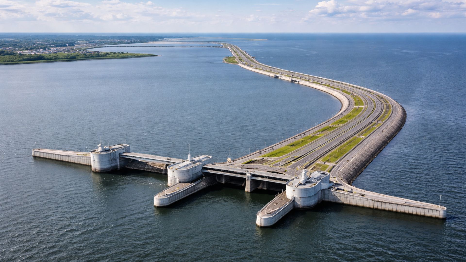
Flood Prevention Button Hidden Under A Highway In The Sea, System Capable Of Stopping The Advance Of Storm Surges And Reducing The Impact Of Storms In The Neva Bay, With Gates That Remain Open Most Of The Time And Close Only When The Risk Increases, In The Largest Complex Of Its Kind In The Region.
Anyone crossing the connection between the shores of the Gulf of Finland, in the St. Petersburg region, may have the impression of being just on another stretch of highway over the sea.
However, beneath the asphalt and between the stone slopes, there is a system designed to do something unusual: keep most of the time water flowing freely and, when forecasts indicate a risk, “close” the way of the storm surge in a matter of minutes to prevent rising sea levels from pushing water into the Neva River bay.
NASA describes that the flow can be interrupted in up to 45 minutes and that the gates, in general, remain open in daily life.
-
Survivor of 1966 SS Daniel J. Morrell Shipwreck in Lake Huron Recounts 38-Hour Ordeal in Extreme Cold

-
The Greatest Hoax in World Cup History? The Film That Denied Brazil’s 1958 Victory and Exposed How Fake Evidence Can Seem Convincing on TV
-
Fake South Korean Online Stores Offer Shopping Thrill Without Spending Money or Receiving Products
-
The War of Jenkins’ Ear: How a Severed Ear Sparked One of the 18th Century’s Most Unusual Conflicts


Advancement Of The Storm Surge And Flood Risk In St. Petersburg
The reason for this solution lies in the geography. St. Petersburg was built in a low area, at the transition between the Neva Delta and the Neva Bay, and the city has historically dealt with flooding associated with storms in the Baltic.
A technical study by HR Wallingford summarizes the mechanism behind the problem: strong winds and low atmospheric pressure can generate sea level rises that advance through the Gulf of Finland, raising water levels in the bay and putting pressure on vulnerable urban areas.

How The 25 Km Barrier With Gates And Navigation Channels Works
The structure, formally known as the flood protection complex, functions as a long barrier that crosses the estuary and organizes the “passages” of water and navigation.
In the design described by HR Wallingford, the system is about 25.4 km long and combines 11 sections of stone and earth dikes with openings controlled by gates.
There are six sluices to accommodate the flow between the Neva Bay and the Gulf of Finland, and two navigation passages: a main channel 200 meters wide, capable of receiving large ships and closed by sector gates, and a secondary channel of 110 meters, closed by a vertical gate.
Why The System “Disappears” In Daily Life And Appears When The Water Rises
This design helps explain why the work is often called “invisible” in everyday life.
Under normal conditions, the openings allow for water exchange and the circulation necessary for the function of the estuary and navigation, while the barrier acts as mobility infrastructure.
When the threat of flooding increases, the system is operated to reduce the risk of the storm surge raising sea levels in the urban area.
NASA also reports that, since it became operational, the complex has been activated more than a dozen times over approximately ten years, precisely because it relies on alerts and quick decisions for closure.
Neva River Level And Operation During The Gate Closure
On the “outside,” facing the Gulf of Finland, the complex takes the impact of the storm wave; on the “inside,” facing the Neva Bay, are the areas whose lower level increases sensitivity to the advance of water.

Technical documents describe that, during closure, the Neva itself continues to discharge water into the bay, which requires the system to be sized to handle the temporary accumulation of water upstream.
HR Wallingford indicates that, with the gates closed, the upstream level can rise by about 0.5 meters per day, a rate considered tolerable within the operational concept adopted.
Highway, Underwater Tunnel, And Bridge: The Infrastructure Above The Dike
The “most visible” layer of the project is the highway.
The HR Wallingford study describes that an expressway was built over the dikes as part of the city’s ring road, including a road tunnel under the main navigation channel and an elevated structure with a drawbridge over the secondary channel.
In the institutional material from the operator of the complex, the highway appears as a maritime section of dual carriageway with three lanes in each direction, a permitted speed of 110 km/h, and a designed capacity of up to 30,000 vehicles per day.
What Comprises The Complex: Dikes, Bridges, Tunnel, And Road Connections
The numbers of the work reinforce the character of “hybrid” infrastructure, both hydraulic and roadway.
In an institutional page, the operator lists the composition of the complex with 11 dikes, six water passage structures, two ship passage structures, seven road bridges, one underwater road tunnel, and associated road connections, totaling 25.4 km (with 22.2 km above the water surface).
Long Construction And Resumptions Until Full Operation
The history of the project helps to understand why it still arouses international curiosity.
NASA reports that the work began in 1979 and that authorities declared the system operational in 2011, after a long execution process and resumptions.
HR Wallingford states that the construction of the system began in 1980, went through interruptions associated with environmental concerns and reduced pacing for years, and gained a stage of decisive advancement from the 2000s onward, when the system became capable of closing the gates before full completion.
Reuters, while reporting the completion of the complex, also described the undertaking as a Soviet project abandoned due to costs and resumed years later, with a launch marked by federal authorities.
Environmental Impact Study And European Standards Cited In Public Documents

The environmental discussion, by the way, was at the center of the resumption.
An executive summary of the Environmental Impact Study published by the European Bank for Reconstruction and Development (EBRD) describes that, to provide complete flood protection, the system would need to be completed, and details alternatives for completion that addressed the barrier itself and provisions for a future highway.
In the same document, the EBRD points out that the completion and operation were designed to meet Russian and European environmental and health and safety standards and that the work would not have significant negative impacts on the environment of the Neva Bay and the Gulf of Finland when compared to the existing situation at that time.
Funding And Billion-Dollar Figures Cited By Institutions
International funding appears in public records linked to the undertaking.
The EBRD itself describes the project as the proposal to complete a flood defense barrier for a low-lying city, focused on reducing flood risk.
The European Investment Bank (EIB) has a public file on the “St Petersburg Flood Barrier Project,” aimed at completing the barrier through the Neva Bay to reduce flood risk, indicating proposed funding in the order of tens of millions of euros for the project structure.
When it comes to total cost, public sources report figures in the billions.
NASA states that the structure was a US$ 3.85 billion project, designed to withstand storm surges of up to 5 meters.
In a technical paper presented by HR Wallingford, the estimated cost to complete the barrier is around US$ 3 billion, with a relevant observation for those looking at the work “only as a dike”: more than 50% of the total, according to the study, may be attributed to the construction of the six-lane highway, including the tunnel beneath the main navigation channel and the bridge associated with the other channel.
The practical effect of the system, described by institutional observers, is to reduce risk at a critical point: the intersection of a historic city, modern infrastructure, and a storm regime capable of raising sea levels in a matter of hours.
NASA states that vulnerable areas of the historic center have not experienced damaging floods since the complex opened, emphasizing that the set tends to attract attention precisely when the gates come into operation.
With the barrier installed, a question now accompanies any debate about large-scale coastal solutions:
When a city decides to “close the sea” to protect its urban area, what is the acceptable limit between security, environmental impact, and growing dependence on mega-infrastructures to deal with extreme events?


-

-

-

-

-

28 people reacted to this.