Portuguese
  Spanish
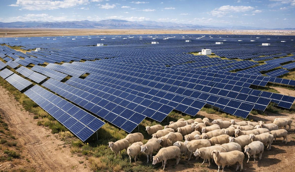
A 1 GW Solar Park in Qinghai, Western China, Is at the Center of a Study Mapping Changes in Soil and Microclimate in a Desert Area, with Comparisons Between Strips Inside and Outside the Photovoltaic Installation.
Solar Park in Qinghai and Environmental Impacts
A large-scale solar park installed in the Talatan Desert, in Qinghai Province, Western China, has also been analyzed for potential environmental effects in the surrounding area, in addition to electricity generation.
A study published in the journal Scientific Reports evaluated the Gonghe photovoltaic complex and concluded that the presence of the panels is associated with changes in local soil conditions and microclimate, with better environmental indicators within the area directly occupied by the plant than in nearby zones without the same intervention.
In the research, the authors analyze a plant of about 1 gigawatt in the Qinghai Gonghe Photovoltaic Park and compare three strips: the “on-site” area where the park’s structures are located; a transition zone; and an “off-site” area, outside the direct influence of the project.
-
The man who started by cleaning bricks and unloading wagons entered the warehouses of Dallas and helped transform commercial real estate into a billion-dollar business.

-
An entrepreneur from Alagoas started by selling organza bags as extra income, ventured into digital after motherhood, and transformed personalized packaging into a national business that sells 35,000 units per month, generates about R$ 60,000, and employs 14 people.

-
While playing video games in his room, a 13-year-old teenager was struck by a lightning bolt that entered the house, left a hole in the wall, passed through a metal piece of the desk, and made the boy scream, thinking he was going to die.

-
A metal detector led a prospector to a rock that resisted a saw, acid, drill, and sledgehammer; years later, scientists cut the block with diamond and discovered a 17 kg meteorite from the beginning of the Solar System.


By standardizing measurements and applying a composite index, the work points to a central result: the park area performed better environmentally than the comparative strips, although the overall classification assigned to the site by the researchers is not the highest within the scale used in the study.
DPSIR Method and the 57 Indicators Analyzed
To assess impacts in an arid and high-altitude environment, the team adopted the DPSIR framework, an English acronym for Driving Force, Pressure, State, Impact, and Response.
The model is used in environmental assessments to organize relationships between human activity, ecosystem changes, and management responses.
The article describes the creation of a system with 57 indicators to capture, in an integrated way, variations in local climate, soil, vegetation, and biological components.
Among the items considered, the researchers list measures related to soil temperature and moisture, air conditions, physical and chemical characteristics of the soil, and parameters associated with plant and microbial communities.
The monitored area has specific characteristics.
The study situates the park at about 2,910 meters above sea level, in a region described as arid desert and semi-arid grasslands.
The authors also record long-term climate averages, with an annual temperature of about 4.1 °C and annual precipitation of 246.3 mm, in addition to a high evaporation rate, typical of dry environments.
Shadows of the Panels, Microclimate, and Soil Moisture
The work discusses how the installation alters energy distribution on the surface and creates different conditions in the microenvironment.
In practice, the panels introduce areas of recurrent shade and change the exposure of the soil to direct radiation, factors that can influence evaporation, temperature, and water retention, as described by the researchers.

By comparing the three analyzed strips, the authors report a pattern: the set of environmental indicators was more favorable within the park than in the transition zones and outside the area of influence.
In the calculated composite index, the area of the project (WPS, in the study’s acronym) scored 0.4393, while the transition zone (TPS) scored 0.2858 and the external area (OPS) 0.2802.
Based on these results, the article states that the observed effects concentrated primarily on variables related to the microclimate and the physical and chemical properties of the soil, as well as indicators related to plant and microorganism diversity.
The interpretation presented in the study is that this set helps explain why the park area performed better than the compared zones.
Renewable Energy and Desertification Combat in China
The installation in Qinghai is described in the study as part of a Chinese strategy for expanding renewable energy in desert regions.
In parallel, authorities and international reports note that the country has also associated part of this expansion with policies to contain desertification, with projects aimed at reducing sand mobility and soil degradation.
This type of initiative is often linked to the program known as “Three Norths,” launched in 1978 and planned to continue until 2050, aimed at combating desertification in large areas of the northern part of the country.
The program is cited in official documents and statements, as well as in reports and journalistic coverage on reforestation and soil protection measures in China.
In the case of solar parks in arid areas, a line of argument present in reports is that the structures can act as barriers against wind and dust and, in some situations, reduce soil evaporation by providing shade.
A Reuters report on such projects in desert regions mentions that the combination of panels and cultivation can decrease moisture loss and facilitate the establishment of plants adapted to the environment.
“Photovoltaic Sheep” and Use of Space Under the Panels
In addition to the academic analysis, the region of Gonghe appears in reports and public records as an example of using the space between rows of panels for grazing activities.
A report described that thousands of sheep, nicknamed “photovoltaic sheep,” roam among the panels in areas with low vegetation, in a model associated with land management and animal husbandry.
The same report attributes to a local manager the assessment that the combination of energy generation and grass growth under the structures allowed residents to return to grazing livestock in the area.
The passage was presented as a statement about the coexistence of electric production and land use in an environment marked by desertification.
Nevertheless, the study from Scientific Reports does not treat this arrangement as an economic balance or public policy, but rather as a cutting of ecological and environmental indicators.
Therefore, the authors maintain focus on the measured results and on the comparison method between areas with and without direct influence from the park.
Long-Term Monitoring and Variations Between Deserts
Although the composite index indicates relative improvement within the park area, the article emphasizes that the assessment reflects measurements organized in a set of indicators and applied to a specific spatial cut.
The authors advocate for improving management responses and maintaining monitoring to understand how variables such as water, soil, and biological composition behave over time in arid environments subjected to persistent changes in the microclimate.
The text also emphasizes that results may vary according to local conditions and implementation methods.
Factors such as topography, rainfall regime, wind, soil type, and human management of the surrounding area influence how a desert responds to changes in shade and ventilation created by the infrastructure, according to the discussion presented in the article.