Portuguese
  Spanish
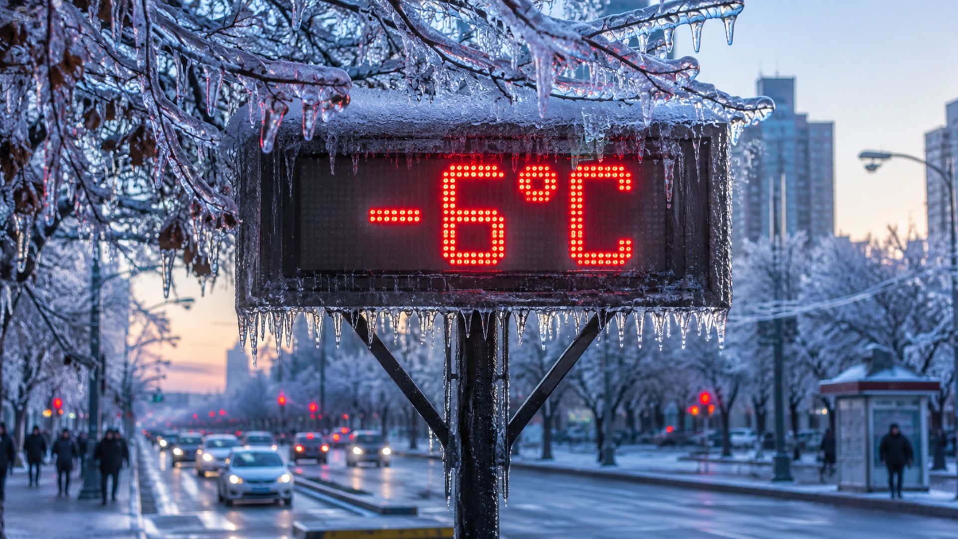
Polar air mass advances through the Center-South and is expected to cause freezing dawns, frost risk, and negative temperatures in high-altitude areas, with greater impact in the South and also affecting São Paulo, Mato Grosso do Sul, and Rio de Janeiro.
The advance of a polar air mass is expected to make this Tuesday (16) the coldest period of the current incursion over the Center-South of Brazil, with a risk of negative temperatures in the South and a sharp drop in thermometers in São Paulo, Mato Grosso do Sul, and Rio de Janeiro.
According to a report published by the site Meteored Brasil, the cold air gained strength after the combination of a cold front in the ocean and areas of instability between the Southeast and the Midwest, a condition that favored the entry of the polar mass over part of the country.
Between this Tuesday (16) and the early hours of Wednesday (17), the most critical condition is expected to mainly affect high-altitude areas of Rio Grande do Sul and Santa Catarina, where the terrain favors lower marks during the night.
-
At 76 years old, a retired man reveals a subterranean labyrinth he dug by hand for 30 years under his own garden, descending 6 meters into sand dunes, erecting 1.5-meter concrete walls with calculations from his mathematician wife, and transforming a “crazy” idea into a hidden cave with a bridge and waterfall.

-
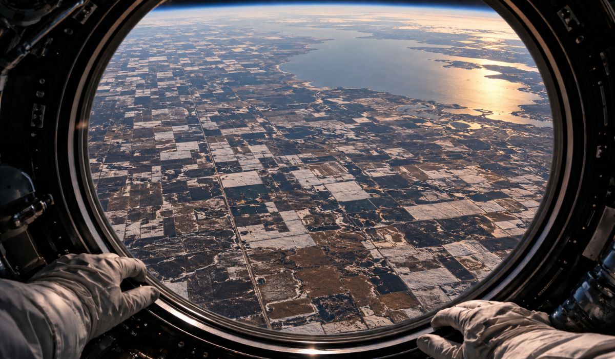
Seen from space, an astronaut captures in Canada a geometric carpet of crops drawn over the backdrop of a ghost lake that disappeared 12,000 years ago, was once larger than all the Great Lakes combined, and left a scar of fertile mud that still sustains agriculture.
-
Billionaire says the most valuable skill will help overcome job elimination caused by AI, following Bill Gates’ fears

-
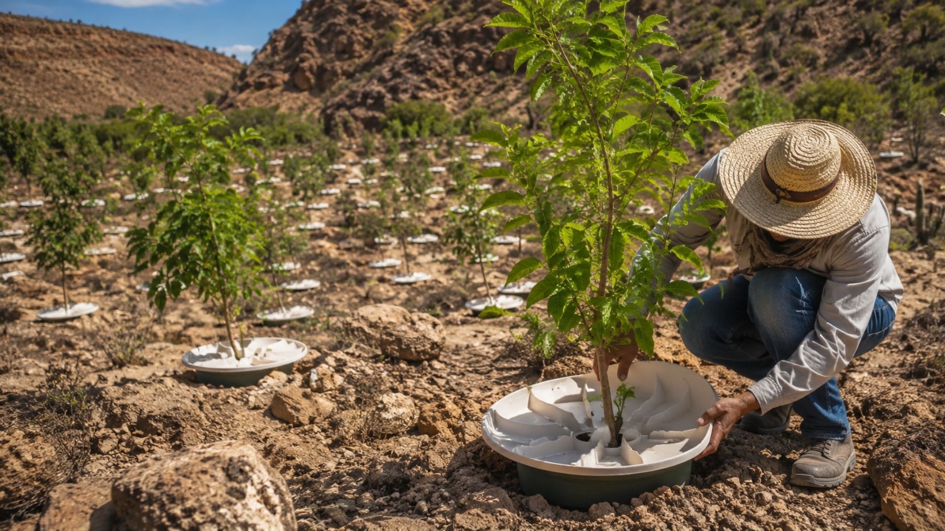
A Dutchman created a ‘box’ that makes trees grow in the desert almost without water and without irrigation: the invention has already brought seedlings to dozens of countries and achieves up to 90% survival where common planting did not exceed 10%.


In Santa Catarina, the projection indicates a chance of negative temperatures throughout the Serra and the Plateau, with the possibility of lows of up to -6°C in colder spots, especially in lowlands and higher altitude areas.
Polar air mass advances through the Center-South
With southern winds transporting cold air into the continent’s interior, the polar mass began to advance more strongly on Monday (15), right after the change in weather pattern caused by the cold front in the ocean.
The drop in temperatures, previously more concentrated in the South, also reached Mato Grosso do Sul, São Paulo, and Rio de Janeiro, although the higher intensity remains restricted to the southern states, especially in mountainous regions and higher altitude points.
In Rio Grande do Sul, the lowest temperatures are expected in areas of the Campanha, the South, the West, the Serra, the North, and part of the Central region, with a greater feeling of cold during the early morning and early morning hours.
According to the forecast from Meteored Brasil, the cold gained new momentum this Tuesday (16), with the potential for below-zero temperatures in the Serra Gaúcha, the northern part of Rio Grande do Sul, the Serra Catarinense, the Mid-West of Santa Catarina, and the extreme south of Paraná.
In the Porto Alegre region, the drop is expected to be less intense than in the mountainous areas, but the capital and Metropolitan Region still feel a marked change compared to previous days, with wind and humidity increasing the feeling of cold.
Serra Catarinense may experience extreme cold
The regions of higher altitude in Santa Catarina and Rio Grande do Sul are at the greatest risk of extreme cold during this polar wave, as they combine high terrain, colder nights, and greater heat loss during the early morning.
In the Serra Catarinense and the Plateau, models indicate negative temperatures, while specific points may record even lower readings due to the accumulation of cold air in valleys, lowlands, and areas far from urban centers.
This behavior often causes the temperature near the ground to be lower than predicted for the city as a whole, since meteorological models do not always accurately capture the local variations in terrain.
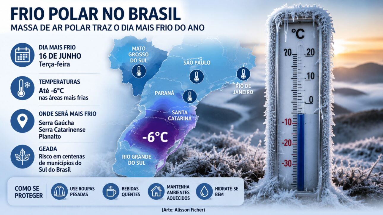
The site Meteored Brasil also pointed out that isolated points in the Serra Catarinense may approach -6°C, especially in lowlands and higher altitude areas, where the cold remains trapped for longer during the early morning.
On Monday (15), the intensity of the polar mass had already appeared in negative records in the South, according to CNN Brasil, which cited data from Climatempo and reported a minimum of -4.7°C in São Joaquim, in the Serra Catarinense.
Frost puts hundreds of cities on alert
In addition to the drop in temperatures, the cold wave increases the risk of frost in parts of the South of the country, a phenomenon favored by intense cold air, humidity near the ground, clearer skies, and heat loss during the early morning.
The National Institute of Meteorology issued a potential danger warning for frost in 333 municipalities, according to a survey cited by Meteored Brasil, with a higher concentration of cities under alert in the Serra Gaúcha, Serra Catarinense, and areas of the central and southern regions of Rio Grande do Sul.
Throughout Rio Grande do Sul, frost may appear widely in the Serra, Campanha, North, and points of the Central region, while Santa Catarina is expected to have a more concentrated risk in the Serra, Plateau, and part of the Midwest.
In Paraná, the possibility of negative temperatures is lower and tends to be more restricted to the extreme south of the state, although inland cities may still experience cold mornings and Curitiba may also feel the drop in temperatures.
São Paulo, Mato Grosso do Sul, and Rio feel the drop
Outside the Southern Region, the polar air mass arrives with less intensity, but still alters the weather pattern, especially in the early hours of the day, when the cold tends to be more noticeable in elevated areas and inland.
In São Paulo, the lowest temperatures are expected between the end of the night and the early morning, with greater impact inland, in the metropolitan region, and in high-altitude areas, while the coast registers higher minimums due to maritime influence.
Even without extreme cold on the São Paulo coast, wind and humidity can enhance the feeling of cold throughout the day, especially in exposed areas, where the change in wind direction reinforces the perception of thermal drop.
In Mato Grosso do Sul, the cold is concentrated in the central-southern part of the state and is expected to be felt more strongly during the night and early morning, while Rio de Janeiro receives the cold air more moderately.
According to the forecast, mountainous areas and the southern part of Rio de Janeiro may experience a temperature drop, but without the same potential for negative marks observed in the mountains of Rio Grande do Sul and Santa Catarina during this polar incursion.
Cold arrives before the official winter
A few days before the official start of winter in the Southern Hemisphere, scheduled for June 21, 2026, the cold wave reinforces a common pattern of the transition between seasons, when cold fronts become more frequent.
Even still in autumn, polar air masses can advance strongly through Brazil at this time of year, especially when frontal systems in the ocean pave the way for the entry of cold air of polar origin.
In this incursion, the difference lies in the intensity of the temperature drop and the reach of the cold mass, which is not limited to the South and also influences parts of the Southeast and Midwest throughout the week.
The next cold front is expected to advance between the 19th and 20th, with the return of rain to the Southern Region, according to a forecast cited by CNN Brazil, while the polar mass maintains frosty nights, frosts, and very low temperatures in the last week of autumn.