Portuguese
  Spanish
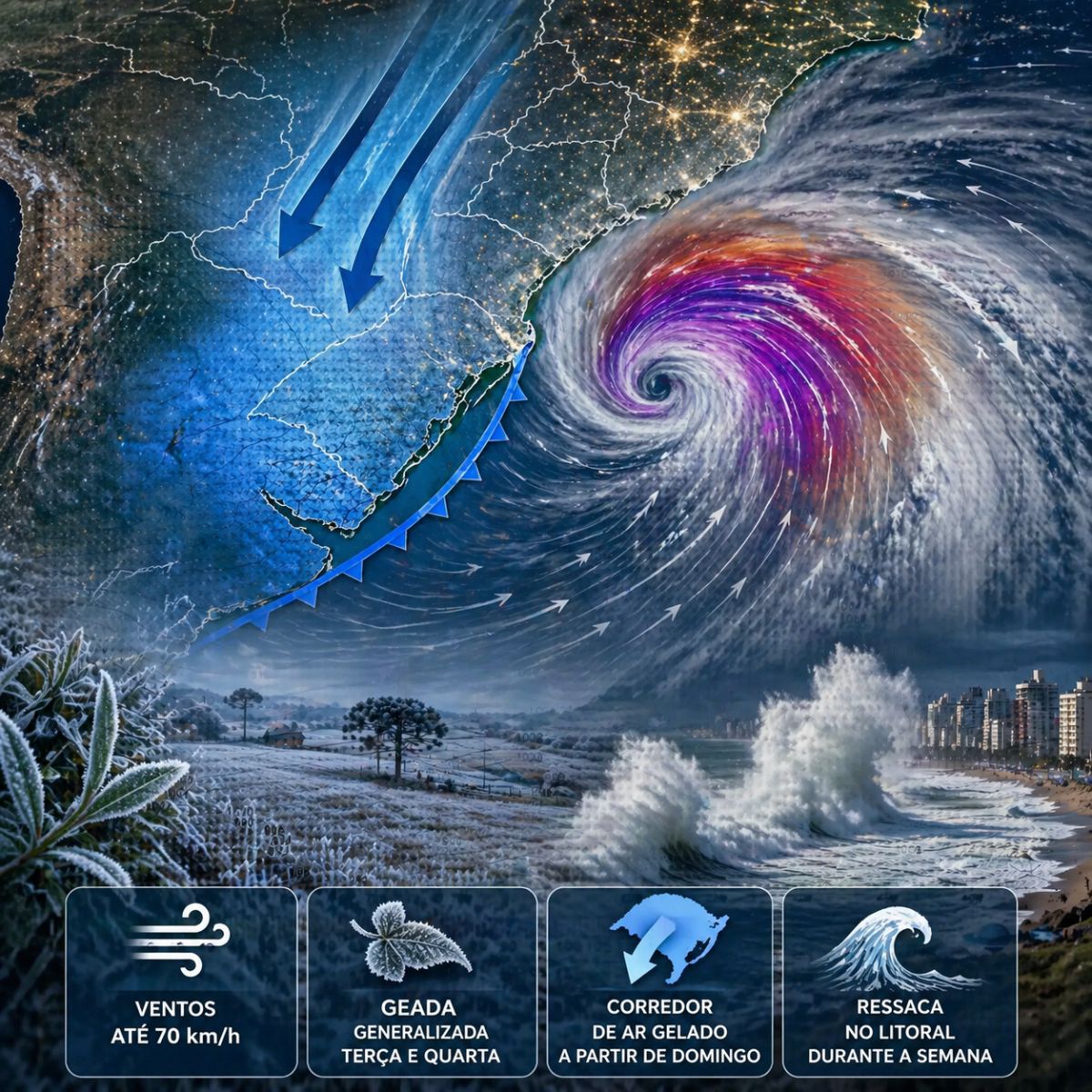
An extratropical cyclone forming off the coast of Patagonia this Saturday (25) will drive a corridor of cold air from the Falkland Islands towards Rio Grande do Sul starting Sunday. The MetSul forecasts winds with gusts of 50 to 90 km/h, widespread frost between Tuesday and Wednesday with lows below 0°C in the mountains, and a risk of rough seas along the coast of Rio Grande do Sul during the week.
The cyclone forming over the South Atlantic this weekend will not directly hit Rio Grande do Sul, but its effects will be felt strongly. The system will create a corridor of cold air transporting icy masses from the Falkland Islands and South Georgia to southern Brazil, dropping temperatures starting late Sunday (26). The arrival of the cold will be accompanied by winds with gusts of 50 to 70 km/h in the south and east of the state, potentially reaching 80 to 90 km/h in parts of the southern coast of Rio Grande do Sul.
The cyclone forms from a low-pressure center that begins to deepen this Saturday off the Argentine coast of Patagonia. Subsequently, the system moves north and northeast towards the mouth of the Río de la Plata, where it gains intensity and passes close to the coast of Buenos Aires province with gusts that may exceed 100 km/h. The most severe impacts on Argentina and Uruguay are expected to occur today, tomorrow, and Monday, while for Rio Grande do Sul, the effects will concentrate between Sunday and Wednesday, with the coldest nights on Tuesday and Wednesday.
How the cyclone will create the corridor of cold air affecting southern Brazil

The mechanism bringing cold to Rio Grande do Sul is the circulation of the cyclone in the South Atlantic. As the system rotates counterclockwise, it pulls cold air from the extreme latitudes of the continent northward, forming what meteorologists call a “tongue of cold air” extending from the Falkland Islands to southern Brazil. The model from the European Meteorological Center clearly shows this configuration in the forecast maps.
-
Humanoid Robots Begin Replacing Workers in Repetitive Roles as Companies Accelerate Industrial Automation

-
Humanoid Robots Begin Replacing Factory Workers in China, Working 64-Hour Shifts and Driving Industrial Automation Forward

-
Miniature Nuclear Reactor to Be Installed in South Wales, Powering 20,000 Homes and Reviving UK’s Nuclear Industry After Nearly 50 Years
-
San Andreas Fault Reaches “Highest Tension in 1,000 Years,” Raising Fears of the “Big One,” but New Study Identifies Key Zone Near Los Angeles Influencing Earthquake Impact


The cold air begins to enter the state between the afternoon and evening of Sunday from the west and south, advancing to other regions on Monday (27). The central pressure of the cyclone is expected to reach 970 hPa in open water, a very low value for mid-latitudes, indicating an intense system capable of keeping the cold corridor active for several days. Although the cyclone moves away from the continent early in the week, its effects on Rio Grande do Sul persist until Wednesday.
Which days will be the coldest and how much can the temperature drop
The coldest nights are expected to occur between Monday and Wednesday, with the peak of cold on Tuesday (28) and Wednesday (29). The majority of Rio Grande do Sul is expected to register lows of 5°C to 10°C, with several cities recording values below 5°C, especially in higher altitude locations. The Serra do Sudeste, the Campos de Cima da Serra, and the Southern Plateau of Santa Catarina may have temperatures around 0°C and even negative.
The frost will have significant coverage. Various regions of Rio Grande do Sul and part of Santa Catarina are expected to register frost formation, especially on Tuesday and Wednesday, except for Greater Porto Alegre and the northern coast, where maritime humidity prevents temperatures from dropping enough for ice crystallization. However, the afternoons will not be harsh: the highs are expected to be between 15°C and 20°C on Monday and Tuesday, indicating that the cold concentrates in the early mornings and late nights.
Winds of up to 90 km/h and the risk of rough seas along the coast of Rio Grande do Sul
The cyclone doesn’t just bring cold. Winds intensify in the South and Campanha Gaúcha late Sunday with the arrival of cold air, blowing with gusts of 50 to 70 km/h on Monday in the South and East of the state. In some parts of the Southern Coast, winds can reach 80 to 90 km/h, a speed sufficient to knock down trees, cause roof damage, and lead to power outages.
In the open sea, the strong wind generated by the cyclone is expected to cause rough seas along the Gaúcha coast throughout the week. The rise in waves can affect coastal areas and hinder navigation, requiring attention from residents of regions near the sea and those who work with fishing or port activities. The combination of strong winds, cold, and rough seas creates a scenario of instability that deserves constant monitoring in the coming days.
What happens in Argentina and Uruguay before the cold reaches Brazil
Before reaching Rio Grande do Sul, the cyclone causes damage in Argentina and Uruguay. The coast of Buenos Aires province is expected to be the most affected, with rain, low temperatures, and very strong winds that can register gusts near and above 100 km/h between Bahia Blanca and Mar del Plata late Sunday and on Monday.
In Uruguay, the departments of Montevideo, San José, Canelones, and Maldonado are expected to face storms with gusts of 75 to 100 km/h, with the possibility of isolated winds above 100 km/h in Costa del Oro and the Punta del Este area. Fallen trees and power outages are expected late Sunday and on Monday, highlighting the intensity of the system which, even as it moves away from the continent, maintains enough strength to impact three countries simultaneously.
How long will the cold last and when will temperatures rise again
The cold spell will not be prolonged. From Wednesday afternoon (29), the air already begins to warm up, and on Thursday, minimum temperatures should be higher than on previous days, although the early morning will still retain remnants of cold. The rapid end of the event is characteristic of autumn cold air masses, which do not have the same persistence as typical winter cold waves.
Between Thursday and Friday, temperatures return to milder levels before a new rain episode expected for the end of the week. For those living in Rio Grande do Sul and Santa Catarina, the recommendation is to use the next few days to prepare, ensuring warm clothing, protecting crops sensitive to frost, and checking the fastening of tiles and structures that may be affected by the strong winds at the beginning of the week.
Are you in the path of this cyclone or have you already felt the first signs of cold arriving? Tell us in the comments what the weather is like in your city and if you believe the heavy coat will come out of the closet earlier than expected this year.