
 Portuguese
  Spanish
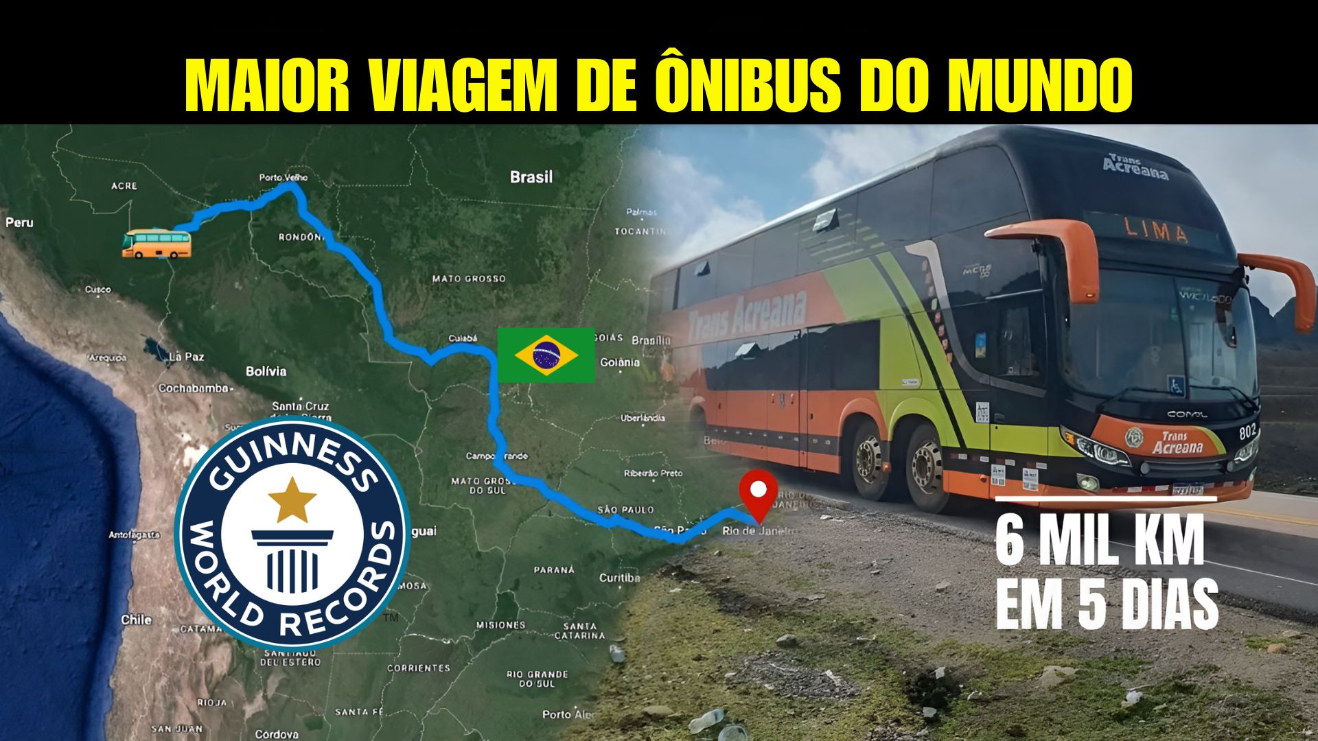
Connecting The Atlantic To The Pacific, The Largest Bus Route In The World Connects Rio De Janeiro To Lima On A Long Journey, Recognized Internationally And Marked By Logistical Challenges, Geographical Diversity And Continuous Operation.
The largest regularly operating bus route in the world departs from Rio de Janeiro and goes to Lima, Peru, covering a distance of over six thousand kilometers.
The route is recognized by the Guinness Book and connects Brazilian and Peruvian cities in a journey of approximately five days, operated by the company Transacreana.
The itinerary passes through regions with varied climates and terrains, linking the Brazilian coast, urban and rural areas, the Amazon, and Andean sections before reaching the Pacific coast.
-
7,500-Year-Old Salt Production Traces in Bosnia Uncover Rare Prehistoric Technology and Shed Light on Food History

-
Man Discovers 2,000-Year-Old Roman Cistern with Drone in Brazil

-
Abandoned Mansion in Brazil Unveils 4 BMWs, Home Theater, Indoor Pool, and Numerous Apple Computers
-
One of Brazil’s Most Beautiful Beaches Faces Severe Pollution as River Contamination Exceeds Safe Limits by 50 Times, Fines Could Exceed $10,000


The extent and operational complexity make this line one of the longest road links on the continent.
International Route Between Brazil And Peru

The route starts at the bus station in Rio de Janeiro and goes through municipalities in the Southeast, Center-West, and North, all the way to Acre, the land access point to Peru.
After crossing the border, the bus continues through Amazonian and mountainous cities until it reaches Lima.
Main Cities on the Rio–Lima Route
| Country | Cities Along The Route |
|---|---|
| Brazil | Rio de Janeiro; Guaratinguetá; São Paulo; Campo Grande; Cuiabá; Porto Velho; Rio Branco; Assis Brasil |
| Peru | Puerto Maldonado; Cuzco; Abancay; Nazca; Ica; Lima |
The listed cities correspond to the officially recognized route cited by transportation authorities and the company itself.

Distances And Geographical Characteristics Of The Route
The length of the route includes stretches of plains, areas of tropical forest, and segments of the Andes Mountain Range.
In some points, the route reaches altitudes close to 3,500 meters, according to technical information related to crossing the Andean region.
For reference, here are approximate distances between some well-known stretches of the trip.
Approximate Distances Between Stretches
| Stretch | Estimated Distance |
|---|---|
| Rio de Janeiro → São Paulo | about 430 km |
| São Paulo → Campo Grande | about 1,000 km |
| Campo Grande → Cuiabá | about 690 km |
| Porto Velho → Rio Branco | about 520 km |
| Assis Brasil → Puerto Maldonado | about 140 km |
| Cuzco → Lima | about 1,100 km |
The values are approximate and may vary due to route adjustments, road conditions, and company operations.
Operation And Logistics Of The Largest Bus Route In The World
According to Transacreana, the international line operates with rotating drivers, vehicles adapted for long distances, and continuous maintenance protocols.
The company states that planning takes into account stretches with irregular terrain, temperature variations, and sudden altitude changes.
The buses used have features such as reclining seats, air conditioning, restrooms, USB ports, and scheduled stops for meals and personal hygiene.

For trips that can exceed 100 hours, experts in road transportation emphasize the need for adequate infrastructure to reduce fatigue for the crew and passengers.
Operational Data Of The Rio–Lima Route
| Item | Information |
|---|---|
| Total Length | about 6,000 km |
| Average Duration | 5 To 6 Days |
| Responsible Company | Transacreana |
| Approximate Number Of Stops | around 30 |
| Countries Served | Brazil And Peru |
| Approximate Maximum Altitude | about 3,500 m In The Andes |
Dynamics Of The Journey And Regional Connections
During the crossing, passengers come into contact with regions of distinct characteristics, both in Brazil and Peru.
The stops include municipalities from the Southeast, Center-West, and North, as well as Peruvian cities located in the Amazon and in the Andean mountains.
According to researchers in the field of cross-border mobility, this type of route helps to broaden local residents’ access to services, commerce, and long-distance travel.
The presence of the line also stimulates sectors such as food, accommodation, and support services linked to bus stations and stopping points.

In smaller towns, regional economic specialists point out that the flow of passengers helps to maintain commercial activities aimed at travelers.
Regional Relevance And Recognition By The Guinness Book
The record in the Guinness Book has enhanced the route’s visibility, which has begun to appear more frequently in surveys and reports about long-distance transport.
Additionally, the line follows the infrastructure of the Interoceanic Highway, a corridor used for circulation between Brazil and Peru in different economic segments.
According to analysts of South American integration, connections like this help facilitate travel in regions where transportation options are more limited, especially in the interior of Acre and in Amazonian areas near the border.
Considering the length of the route and the diversity of regions traversed, would you undertake a multi-day journey by road to Lima or would you prefer to explore the route in shorter segments?


Seria legal fazer uma viagem dessa de carro próprio curtindo o trecho se não fosse tão perigoso as estradas hoje em dia
Faltou saber os precos desta viagem
Gostaria da fazer com trechos mais curtos e umas 3 paradas, com dois dias de permanência nas paradas.