
 Portuguese
  Spanish
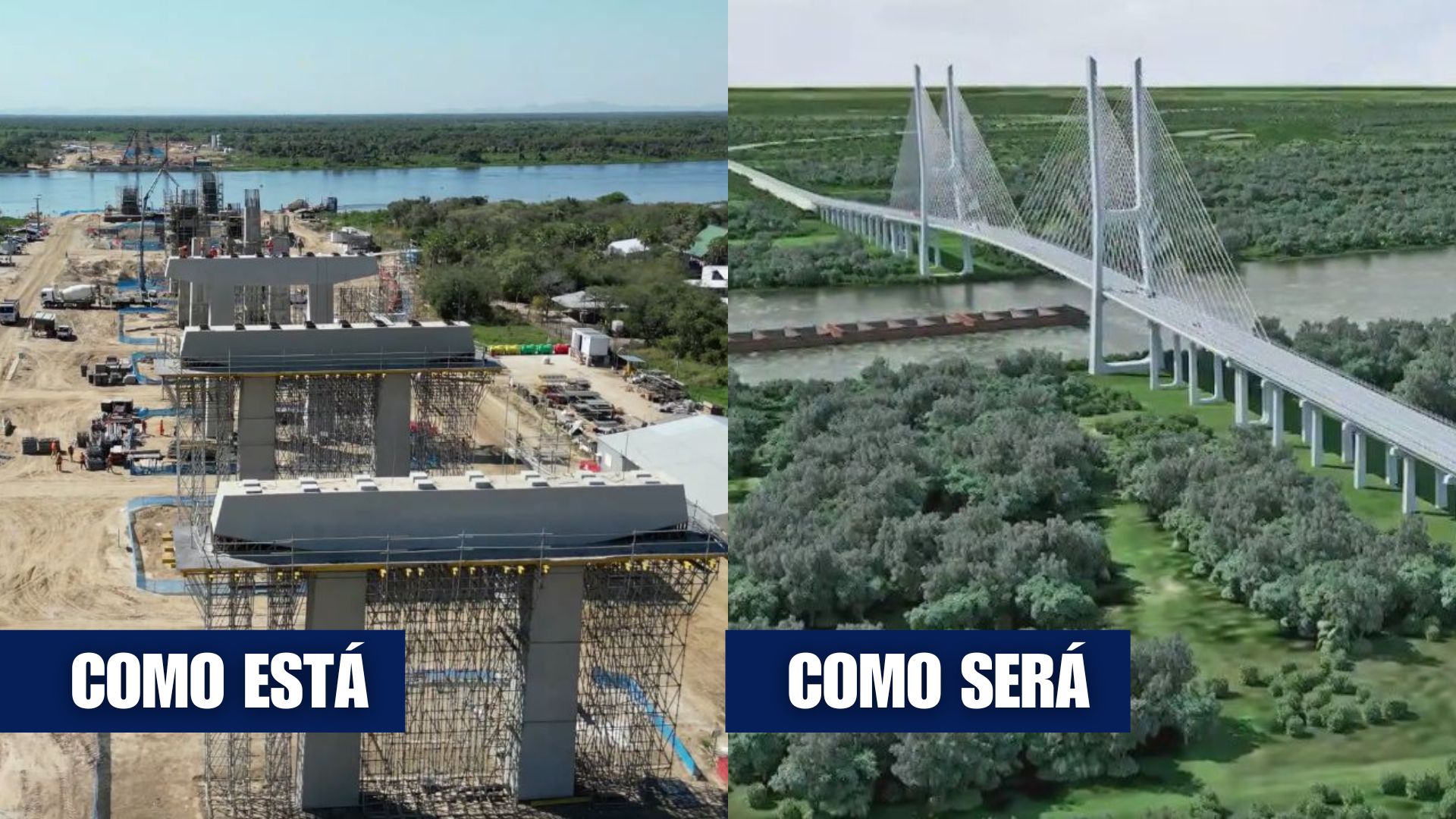


One Of The Largest South American Integration Projects Advances On The Paraguay River, Promises To Change Logistical Routes, And Is Already Transforming Porto Murtinho With New Access, Investments, And Expectation Of Increased International Flow.
The construction of the Bioceanic Bridge over the Paraguay River, between Porto Murtinho (MS) and Carmelo Peralta (Paraguay), has entered the final phase of construction and is already registering over 80% completion, according to recent reports from Brazilian and Paraguayan authorities.
With 1,294 meters in length, a cable-stayed structure in the central section, and financing from the Paraguayan side of Itaipu Binational, the bridge consolidates itself as the main international link of the Bioceanic Road Corridor, which will directly connect the Atlantic and Pacific Oceans and shorten the route of Brazilian exports to Asia.
Cable-Stayed Structure And Engineering Of The Bioceanic Bridge
The project foresees an international bridge with 21 meters in width, two lanes for vehicles, and lateral walkways for pedestrians and cyclists.
-
Brazilian Joins Homeownership Consortium, Faces Decade of Dual Payments Totaling $141,000, Surpassing Traditional Mortgage

-
Land Rover to Halt Production in July, Putting 371 Jobs at Risk, as Chinese Automaker Negotiates to Convert Factory to 100,000 Vehicles Annually by 2027

-
Mexican Pest Threatens U.S. Cattle Herds at Historic Lows, Potentially Boosting Brazilian Beef Exports as Burger Prices Soar

-
Brazilian Freight Bill Progresses in Congress with $5,000 Minimum Wage, 70% Advance Payment, and Fines Up to $1 Million, as Agriculture and Industry Warn of Rising Costs and Legal Uncertainty


The crossing is divided into three sections: two access viaducts, one on each bank, and the central cable-stayed part, which extends 632 meters over the bed of the Paraguay River, including a clear span of 350 meters to ensure navigation of the Paraguay-Paraná Waterway without the need for interruptions.
The main towers of the bridge, which anchor the steel cables responsible for supporting the deck, reach about 130 meters in height, comparable to buildings of more than 40 floors.

The option for the cable-stayed model was defined to ensure a large central span, avoiding pillars in the navigation channel used by bulk and container convoys.
The superstructure combines high-strength steel and special concrete, designed to withstand intense truck traffic under climatic variations and seasonal floods of the river.
Load tests and daily inspections accompany the installation and tensioning of the stays, as the deck advances in successive cantilever from the two central towers.
Investment, Access Works, And Logistical Importance
The total investment in the bridge is estimated at around R$ 575.5 million, an amount equivalent to approximately US$ 100 million, fully financed by the Paraguayan administration of Itaipu.
On the Brazilian side, the National Department of Transport Infrastructure (DNIT) is conducting access works via BR-267, which total 13.1 kilometers in length, including the road bypass of Porto Murtinho, four intermediate bridges over flooded areas, and a customs control center at the border.
This set is budgeted at around R$ 472 million under the New PAC, with work fronts in earthworks, drainage, and construction of special works of art.
On the Paraguayan side, the direct accesses to the bridge total approximately 4 kilometers and connect to highway PY-15, the main axis of the route that crosses the Chaco to Loma Plata.
End Of Ferries And New Flow For Trucks
Today, the crossing of the Paraguay River in Porto Murtinho depends on ferries subject to queues and interruptions during flood periods.
With the new bridge, this stage will be replaced by a continuous road, with vertical clearance compatible with river convoys and lanes prepared for heavy trucks.
Teams work in extended shifts to connect the two sides of the deck and complete metallic guardrails and protective barriers.
Official projections indicate that the bridge will transform Porto Murtinho from a dead-end point into a logistical international hub, redistributing flows currently concentrated in ports such as Santos and Paranaguá.
Bioceanic Corridor And Direct Link To The Pacific
The bridge is the centerpiece of the Bioceanic Road Corridor, an international corridor of about 2,400 kilometers that will connect the Midwest of Brazil to the Chilean ports of Antofagasta and Iquique.
The path starts from Campo Grande and connects Brazil, Paraguay, Argentina, and Chile.

Studies by the Company of Planning and Logistics (EPL) indicate that the new route can reduce the maritime distance of Brazilian exports to Asia by over 9,700 kilometers.
Official estimates also indicate savings of up to 17 days in total travel time and a reduction of about 30% in freight costs.
This change is expected to especially benefit the agribusiness of the Midwest, with a focus on exports of soybeans, corn, and meats.
Regional Impact And Changes In Porto Murtinho
As the works progress, Porto Murtinho is undergoing economic restructuring.
Public and private investments are increasing the capacity of the local port terminal.
The state government and federal agencies are structuring projects to reduce queues and inspection times at the border, with a center integrated next to the accesses of BR-267.
On the Paraguayan side, the paving of the Chaco is advancing in batches that connect Carmelo Peralta to Loma Plata and continue to the border with Argentina.
Environment And Care In The Pantanal
The work fronts operate in a sensitive area of the Southeast Pantanal, which requires licensing and environmental monitoring.
The route studies foresee wildlife crossings, fencing, and programs for monitoring animal collisions.
Mitigation plans include sediment control and adaptations to reduce interference in wild animal routes.
Jobs, Technology, And Timeline Until 2026
At the peak of the works, over 400 workers are operating on the construction sites installed on both banks of the Paraguay River.

The responsible consortium maintains bases with workshops, testing laboratories, and equipment for lifting large segments of the deck.
The schedule foresees the completion of the bridge in the first or second semester of 2026, in line with the progress of road access in Brazil, Paraguay, and Argentina.
Periodic meetings discuss signaling, customs, and inspection procedures.
Regional Integration And Dispute Over Trade Routes
The Bioceanic Route integrates a broader strategy of South American physical integration, complementing ports, railways, and highways.
With the direct link to the Pacific, Porto Murtinho is likely to assume the role of an exit gate for cargo from the interior of Brazil towards Chilean ports.
Cities in Paraguay, Argentina, and Chile along the route compete for investments in terminals, logistics services, and tourism.
With this scenario of accelerated works and ongoing changes, do you believe that this new connection over the Paraguay River will be able to reposition Brazil in trade routes with Asia in the coming years?


Boa reportagem pois eu não sabia da construção dessa ponte o que deve favorecer muito o agronegócio brasileiro
deve ser do contra contra tudo
esse deve ser um dos patriotarios