Portuguese
  Spanish
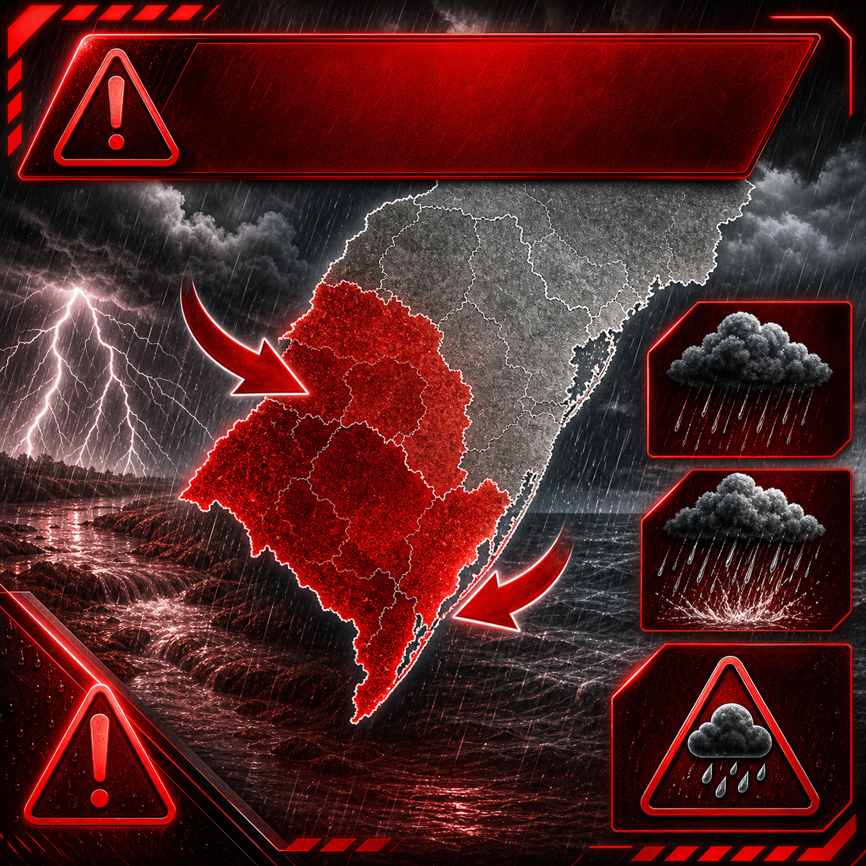
INMET issues orange alert for Paraná and Rio Grande do Sul with intense rain, hail risk, and winds up to 100 km/h, while a cold front advances through the South and drops temperatures to 0°C to 4°C in Gaúcho areas, bringing frost risk right after the holiday weekend storms.
According to Agência Brasil, the National Institute of Meteorology issued two orange-level warnings, a danger classification, this Saturday, May 2, valid for 24 hours for Paraná and Rio Grande do Sul. The alert covers the Serrana, Southwest, Southeast, West, and Central-South regions of Paraná, in addition to Gaúcho areas, with forecasts of intense rain and strong winds. The forecast indicates accumulations that can reach 60 millimeters per day and, occasionally, exceed 100 millimeters in Rio Grande do Sul, with winds between 60 and 100 kilometers per hour. On Sunday, May 3, the advance of the cold front should allow the entry of a dry and cold air mass through Rio Grande do Sul, dropping minimums to values between 0°C and 4°C.
The sequence is tough: first intense rain, with risk of hail and gale; then polar cold, when the sky clears and temperatures plummet. It’s the worst of both worlds concentrated in a single holiday weekend.
Cold front associated with extratropical cyclone reorganizes weather in Southern Brazil this weekend
The system reorganizing the weather in Southern Brazil this weekend originates from a strong cold front, associated with an extratropical cyclone that began to organize over the Atlantic Ocean south of the continent. The system advanced through Rio Grande do Sul starting Friday morning, May 1st.
-
Brazilian mechanic invents simple solar lamp using water and chlorine in a PET bottle, providing up to 60 watts of light during the day

-
Swiss glaciers melting fast enough to fill an Olympic pool every 6 seconds, France confirms 3,700 heatwave deaths, and WMO predicts strong El Niño intensifying extremes until 2027

-
Sudden Sea Recession in São Paulo Sparks Tsunami Alert and Online Debate on Giant Wave Risks in Brazil

-
China Launches World’s First 307-Meter Floating Wind Platform to Supply Oil Rigs, Aiming to Cut 35,000 Tons of CO2 Annually


Climatempo classified the cold front as strong for this time of year, a technical definition indicating a high contrast between the warm and humid air mass that dominated the South and the polar cold air mass that advanced behind the system. The greater this temperature difference, the more energy is available to produce intense rain, strong winds, and hail.

On Friday, the system reached Rio Grande do Sul with storms, heavy rain, lightning, and winds. Throughout Saturday, the front continued to advance with a gradual loss of intensity, but still with forecasts of moderate to strong showers in central and western Santa Catarina, as well as areas in the south, east, and west of Paraná.
Intense rain, hail, and winds up to 100 km/h form a compound severe event in the South
ND Mais documented that Rio Grande do Sul is expected to have intense rain, hail, and winds up to 90 km/h during the system’s passage. These three simultaneous elements characterize a compound severe event, more dangerous than each isolated phenomenon.

Rain reduces visibility, hail increases the risk of rapid damage to crops, roofs, vehicles, and exposed structures, while strong winds can bring down branches, trees, loose objects, and power lines. When everything occurs simultaneously, the population’s reaction time decreases.
INMET’s orange alert indicates a real risk of disruptions, especially in hillside areas, riverbanks, rural roads, regions with deficient drainage, and agricultural properties exposed to wind and hail.
What 100 millimeters of rain in 24 hours means for rivers, hillsides, and rural areas
For most people, 100 millimeters of rain seems like just a technical number. For those living on hillsides, floodplains, or near streams in Southern Brazil, this volume has immediate physical consequences.
An accumulation of 100 mm in 24 hours means 100 liters of water falling on each square meter of surface. In a typical hydrographic basin in western Paraná, with soil already saturated by the rainy autumn, agricultural areas, and rivers nestled between clay banks, this water does not infiltrate quickly enough. It runs off.
When it drains, it goes directly into streams and rivers, raising levels in a few hours. Rainfall above 80 mm in 24 hours historically increases the risk of flooding, erosion on unpaved roads, damage to crops, and localized overflows in Southern basins.
Western Paraná and second-crop corn fields may feel the effects of heavy rain and wind
In western Paraná, where the topography is flatter and clay soils have low infiltration capacity during extreme events, water that does not penetrate the soil quickly forms sheets. This can cover rural roads, low-lying areas of rural properties, and stretches near smaller rivers.
For second-crop corn fields still in the field in early May, especially those with delayed harvesting due to the humid weather of recent weeks, the impact can be significant. Intense rain combined with wind increases the risk of plant lodging.

Lodging makes mechanical harvesting difficult, increases operational losses, and can raise the risk of grain deterioration due to excessive moisture. In a few hours of storm, a crop in its final stage can lose part of its quality and harvesting efficiency.
Hail concerns Civil Defense, agricultural insurers, and producers in Paraná and Rio Grande do Sul
Hail is one of the most concerning elements of the event for Civil Defense and agricultural insurers. In the field, it can cause irreversible damage to corn crops in the final grain-filling stage, breaking stalks, injuring plants, and facilitating the entry of fungi.
In cities, intense hail can clog gutters and storm drains, turn streets into flash flood corridors, and damage vehicles, ceramic tile roofs, metal roofs, and light structures. In dense urban areas, the problem adds to intense rain and the risk of rapid flooding.
Simepar identified a risk of hail throughout Paraná during the passage of the cold front, with a higher probability in the West and Southwest regions. In these areas, the encounter between residual warm air and polar cold air creates favorable gradients for more intense hail storms.
Wind-driven hail increases risk for glass, solar panels, and shed facades

The combination of hail with winds of 60 to 100 km/h can produce what is known as wind-driven hail. In this case, the ice fragments do not just fall vertically but are pushed horizontally by the wind.
This lateral displacement increases the damage potential to surfaces normally less affected, such as side windows, solar panels, shed facades, windows, greenhouses, and agricultural structures. The problem is especially significant in rural areas with exposed equipment.
Photovoltaic panels, poultry house roofs, warehouses, and metal structures can suffer direct impacts, especially if the hail is accompanied by strong gusts and a sudden change in wind direction.
Polar cold arrives right after storms, dropping lows to 0°C to 4°C in Rio Grande do Sul
The weekend’s meteorological sequence has a second act as important as the first. After the intense rain, the cold front advances, dry and cold air enters Rio Grande do Sul, the sky begins to clear, and temperatures drop rapidly.
Agência Brasil confirms that the mass of dry, cold air is expected to lower minimum temperatures to values between 0°C and 4°C on Sunday. This drop occurs precisely after the storms, when the soil and vegetation are still damp.
This combination – clearing skies, dry cold air, and moisture left by the rain – is the classic recipe for frost. The most intense cold is expected to concentrate in Gaúcha areas, on the border with Uruguay, in the plateau, and in mountainous regions.

Frost may affect areas of Campanha Gaúcha, the Rio Grande do Sul plateau, and Serra Catarinense
With the high humidity left by the rain and cold air advancing behind the front, conditions are being carefully monitored by agrometeorologists. Frost occurs more easily on clear-sky mornings, with light wind and intense heat loss from the surface.
Areas at higher risk include Campanha Gaúcha, the Rio Grande do Sul plateau, and mountainous regions of Santa Catarina, where minimums could approach 0°C. CNN Brasil confirmed the possibility of frost in the Gaúcha and Catarinense mountain ranges.
On the border with Uruguay, thermometers could register between 0°C and 4°C in the early hours of Sunday to Monday. After the rain and hail, the concern quickly shifts to intense cold, frost, and impact on sensitive agricultural areas.
Northeast also has an orange alert, but due to tropical rain associated with the Intertropical Convergence Zone
While the South is hit by a cold front of polar origin, the Northeast also has orange alerts from INMET this Saturday, but due to a completely different mechanism. The intense rain in the region is associated with the activity of the Intertropical Convergence Zone.
The alert covers Ceará, Maranhão, Paraíba, and Pernambuco, with the possibility of up to 100 mm of rain per day and winds of 60 to 100 km/h. On the Paraíba coast, volumes of up to 80 mm per day were predicted, with emphasis on Campina Grande, Sapé, and Areia.
The governor of Paraíba has already declared a state of emergency in the affected areas. Brazil enters the first weekend of May with simultaneous orange alerts at both extremes of the country, due to different but equally dangerous atmospheric mechanisms.
South and Northeast face extreme rain due to opposite mechanisms, but with similar risks
The contrast between the systems is total. In the South, the rain comes from a cold front associated with polar air and an extratropical cyclone. In the Northeast, instability is fueled by tropical convection linked to the Intertropical Convergence Zone.
Even with different origins, the consequences can be similar: heavy rain, strong winds, risk of flooding, falling trees, damage to fragile structures, and disruptions in urban and rural areas. The public’s response needs to be similar in terms of prevention.
The central point is that May begins with simultaneous extremes. While one part of the country faces the cold arriving after the storms, another deals with intense tropical rain and the risk of emergency.
INMET guidelines for the next 72 hours include attention to rivers, slopes, lightning, and strong winds
INMET advises the population in areas under orange alert to follow updates from meteorological agencies and Civil Defense. It also recommends avoiding slope areas, riverbanks, and places prone to flooding during intense rain.
During thunderstorms with lightning, the advice is not to shelter under trees and to avoid open areas. Loose objects should be collected, as they can be carried away by wind gusts and cause accidents.
For rural producers, the recommendation is to check drainage systems, protect equipment, observe low-lying areas, and monitor the evolution of alerts. The most critical window is from Saturday night to Sunday morning, when instability and the advance of cold overlap.