Portuguese
  Spanish
Storm advances over Rio Grande do Sul with Inmet red alert, risk of hail, winds above 100 km/h, floods and damage to buildings, while rain already causes punctual disruptions and puts transport on alert in the capital.
The storm gained strength in Rio Grande do Sul and placed more than 470 municipalities under a red alert from the National Institute of Meteorology. The warning indicates a great danger of storms across almost the entire state, with forecasts of intense rain, hail, wind gusts above 100 km/h, and a high risk of flooding, damage to buildings, falling trees, and problems in the road transport system.
In practice, the first effects have already begun to appear in the capital and the metropolitan region. In Porto Alegre, heavy rain lasting about 10 minutes caused water accumulation in a stretch of the northern zone, leading drivers to reduce speed and swerve from the right lane. The situation drew attention because the alert remains in effect until tomorrow and increases concern about new disruptions in the coming hours.
What happened and why the storm triggered the alert in the state
Rio Grande do Sul entered a state of great danger due to the advance of a storm that is already affecting different regions. Inmet’s red warning came into effect late morning and extends until tomorrow, reaching almost the entire Gaúcho territory, with the exception of areas near the border with Santa Catarina.
-
Venice Deploys 78 Massive Steel Gates to Shield City from Extreme Adriatic Tides

-
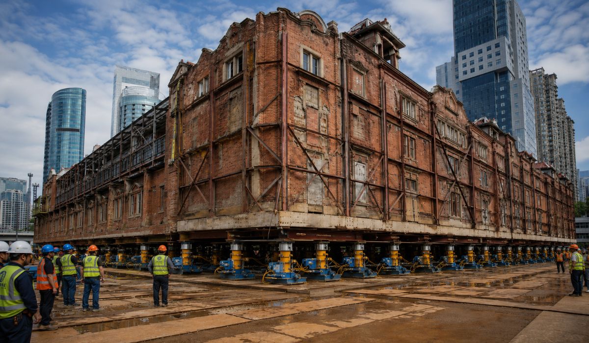
China Uses 432 Robots to Move a 7,500-Ton Historic Building in Shanghai, Preserving Architecture While Creating Space for Underground Center
-
World Cup Ball Chip Uses Technology to Detect Invisible Touches, Confirms Offside, Secures Portugal’s Victory Over Croatia

-
36-Meter Hydrogen-Powered Superyacht Arrives in Brazil to Debut German Engines and Showcase Future of Clean Navigation


What makes this situation especially relevant is the combination of threats in the same event. In addition to intense rain, the alert highlights the possibility of hail, very strong winds, and direct impacts on urban mobility and safety. This turns the storm into a far-reaching episode, with risks for both residents and those who need to travel on roads and urban areas.
The first impacts of the storm have already appeared in Porto Alegre
Although the heavy rain in the capital lasted about 10 minutes, it was already enough to create points of water accumulation on the road. One of the observed stretches was in the northern zone, between Assis Brasil and Dona Alzira, where drivers had to reduce speed and change their trajectory due to the accumulated water.
Up to the moment cited in the report, this was the main point identified in the capital with standing water. According to the traffic agents mentioned, there was no record of incidents involving collisions, fallen trees, or other blockages directly caused by the rain. Nevertheless, the guidance was for increased caution, as the road remained wet and the rain returned, albeit with less intensity.
The numbers that explain the dimension of the red alert
The main data point of the episode is the reach of the meteorological warning. More than 470 Gaúcho municipalities are under a red alert, which places the event among the broadest episodes in terms of recent territorial coverage within the state.
Another impactful number is the predicted wind speed. Inmet warns of gusts above 100 km/h, a mark sufficient to raise the risk of damage to buildings, falling trees, and circulation problems. When this potential is combined with intense rain and hail, the storm ceases to be merely a climatic discomfort and begins to represent a concrete threat to the routine of entire cities.
Where the storm has already been perceived beyond the capital
Messages from listeners and residents show that the effects of the storm were not restricted to Porto Alegre. There were reports of hail in Canoas, rain with thunder in Guaíba, and rain in Gramado, in addition to records of light rain and thunderstorms in other localities.
These reports help to show how the storm spread across different areas of the state and the metropolitan region, with varied manifestations depending on the city. In some places, the highlight was hail. In others, it was thunder, thunderstorms, or the return of rain after an initial period of greater intensity.
What changes in practice for drivers and for transport
For those on the streets or highways, the most immediate effect of the storm is the need to reduce speed and increase the level of attention. Even in stretches without total blockage, the wet road, the risk of accumulated water, and the possibility of falling trees change driving conditions and increase the risk of disruptions.
Inmet itself emphasizes that there is a high risk for the road transport system. This means that the storm can affect urban displacements, inter-municipal travel, and circulation on roads, especially if the combination of intense rain, hail, and strong winds persists throughout the alert period.
Why the red alert is so concerning this time
The red level of the meteorological warning indicates great danger, and this changes the weight of the guidance given to the population. It is not just a generic preventive recommendation, but a sign that conditions can cause more serious damage and require an immediate change in behavior.
Therefore, the official guidance is for people to avoid leaving home and also not to stay outdoors during the storm. When the warning itself already projects the possibility of flooding, damage to buildings, and falling trees, the risk begins to involve not only mobility but direct physical safety.
Cities are already reporting hail, thunderstorms, and heavy rain

Reports sent throughout the coverage reinforce the perception that the storm manifests with different characteristics depending on the region. In Canoas, the information reported was rain with hail. In Guaíba, the highlight was rain with thunder. In other locations, such as Capão da Canoa and Balneário Pinhal, there was a record of light rain and thunderstorms.
This mosaic shows that the storm does not act uniformly. In the same meteorological event, some cities feel the heavier effects, while others face an initial or less intense stage. Still, all remain under the same heightened attention due to the system’s advance over the state.
What authorities advise during the storm
The most direct recommendation is to avoid unnecessary travel while the red alert is in effect. It is also advised not to stay in open areas during the storm, precisely because of the risk of falling trees, hail, and strong winds.
For more information or to call for help in an emergency, the guidance is to contact the Civil Defense and the Fire Department at numbers 199 and 193. These channels gain importance in a scenario where the storm can evolve rapidly and affect different regions almost simultaneously.
The next few hours will be decisive in measuring the impact of the storm
As the alert remains active until tomorrow, the scenario is still developing and may worsen in different parts of Rio Grande do Sul. This means that the disruptions observed so far may be just the first signs of a broader event, especially if intense rain and strong winds advance over more densely populated areas.
It is precisely this combination of territorial reach, wind strength, possibility of hail, and risk to transport and buildings that keeps the storm in the spotlight. More than an isolated rain event, the state is facing a large-scale meteorological condition, with the potential to affect the routine of millions of people in a few hours.
In your city, has the storm already brought hail, flooding, or traffic difficulties?