Portuguese
  Spanish
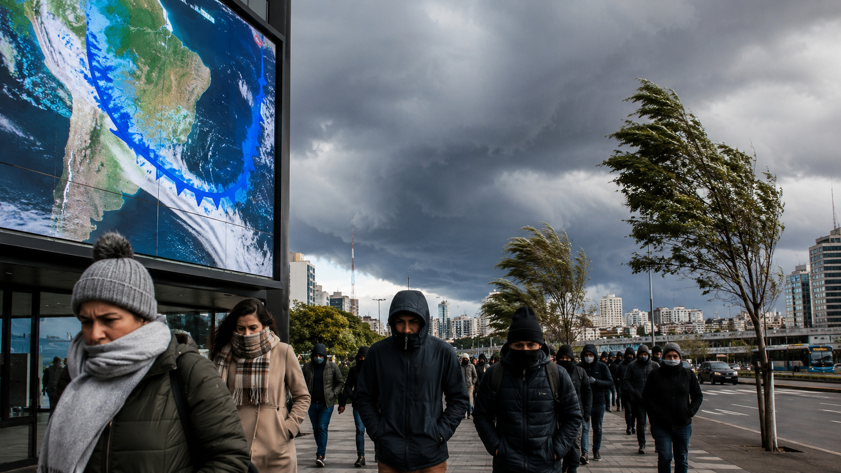
New round of cold fronts, advance of polar air and influence of global atmospheric phenomena should keep the weather unstable in various regions of the country until the end of June, with below-average temperatures and unusual rainfall volumes for the season.
The second half of June promises to maintain the weather pattern that has already caught meteorologists’ attention in the first half of the month. According to information released by Meteored based on projections from the European ECMWF model, a combination of cold fronts, polar air masses, and large-scale atmospheric phenomena will continue to influence the Brazilian climate until the end of June 2026.
The scenario is marked by above-average rainfall in areas of Central Brazil and below-normal temperatures in much of the South-Central region. The trend reinforces a behavior considered atypical for this time of year, especially in states that normally record drier conditions during the period.
According to the analysis published by Meteored in June 2026, the coming days should be marked by successive incursions of cold air, as well as the persistence of frontal systems capable of causing new episodes of significant rainfall.
-
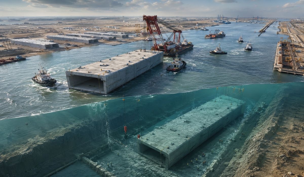
Iraq floats and sinks under an arm of the Euphrates 10 giant concrete boxes of 46,000 tons and 125 meters each to assemble a 2.4 km submerged tunnel and open a new land route between Asia and Europe.

-
Scientists use more than 20,000 artificial birds and solar speakers to “trick” seabirds, reactivate nesting routes, and revive a colony on an island that seemed abandoned.

-
She spent 73 years breathing inside an iron lung, survived the aftereffects of polio, and became the last woman in the United States dependent on the equipment before dying at 78 years old.
-
Brazilian students created a $1 filter using pine bark, cotton, and 3D-printed parts to clean cassava wastewater, reduce the toxicity of a hazardous waste, and transform contaminated water into biofertilizer.


Rainfall remains above average in areas of Central Brazil
The first half of June has already shown behavior outside the climatological pattern. States like São Paulo, Minas Gerais, Goiás, Mato Grosso do Sul, and northern Paraná recorded precipitation volumes higher than expected for the period.
Now, the forecast indicates that this scenario will continue during the second half.
Between June 15 and 22, accumulated rainfall should remain slightly above average in areas of the Southeast, Central-West, North, and interior of the Northeast regions. In some parts of the state of São Paulo and also in the western Amazon, positive deviations may range between 10 mm and 30 mm.
In the last week of the month, between June 22 and 29, the trend is for intensification of rainfall. The largest volumes should be concentrated between Mato Grosso do Sul, northern Paraná, and the interior of São Paulo, where deviations may reach between 30 mm and 60 mm above the climatological average.
This behavior reinforces the continuous action of frontal systems that have been able to advance through the interior of the continent, transporting moisture and favoring the formation of areas of instability.
Polar air mass may cause significant drop in temperatures
In addition to the rains, the cold will continue to be a highlight in various Brazilian regions.
ECMWF projections indicate temperatures up to 3°C below the climatological average between June 15 and 22 in areas of the South Region, western São Paulo, and Mato Grosso do Sul.
However, the most relevant scenario is expected for the last days of the month.
A new and intense polar air mass is expected to advance across the South American continent, reaching even areas of the southern North Region in another cold spell episode. This phenomenon occurs when cold air from high latitudes can penetrate deeply into the interior of South America.
Forecasts indicate temperatures between 3°C and 6°C below average in parts of the South and Midwest regions. In the southern half of the Southeast and in areas of Goiás, thermometers may register values up to 3°C below normal for June.
Meanwhile, the northern strip of the country should remain under the influence of above-average temperatures, highlighting the climatic contrast between different Brazilian regions.
Global phenomena help explain climate behavior
Experts point out that the maintenance of this atmospheric pattern does not occur by chance.
Among the monitored factors is the Antarctic Oscillation (AAO), a phenomenon that directly influences the trajectory of extratropical cyclones and cold fronts in the Southern Hemisphere.
According to climate models, the AAO is expected to reach positive values during part of the second half of June before migrating to neutrality or a negative phase. This transition usually favors the displacement of frontal systems to lower latitudes in South America, increasing the frequency of cold air incursions over Brazil.
Another important element is the Madden-Julian Oscillation (MJO), considered the main mode of intraseasonal atmospheric variability in the tropics.
The forecast indicates that the MJO will be active over the Western Pacific at the end of the month, favoring areas of convection and increasing the potential for the formation of instabilities in parts of the North, Midwest, and Southeast regions.
Additionally, meteorologists continue to monitor the warming of the Equatorial Pacific waters associated with El Niño. The phenomenon continues to exert influence on global atmospheric circulation and may contribute to maintaining the pattern of above-average rainfall in various areas of the national territory.
What to expect until the end of June?
The set of atmospheric indicators points to the continuity of the pattern observed since the beginning of the month.
In practice, this means that several regions of Brazil will have to face new rounds of rain, in addition to the arrival of cold air masses capable of significantly dropping temperatures.
For residents of the South, Southeast, and Midwest, the recommendation is to follow meteorological updates in the coming days, as the advance of the polar air mass may cause rapid changes in weather conditions.
With the combination of frequent cold fronts, the influence of the Antarctic Oscillation, the action of the Madden-Julian Oscillation, and the effects of Pacific warming, June is on track to end with climatic characteristics quite different from those normally observed at this time of year.