
 Portuguese
  Spanish
Mayan city hidden for centuries under the Mexican jungle was revealed after a student found laser data on page 16 of Google and turned a forgotten environmental file into an archaeological discovery
A doctoral student reached where almost no one goes: page 16 of Google. It was there, far from the jungle, without excavation, without expedition, and without cutting a path through trees, that he found the clue that would lead to one of the most impressive archaeological discoveries in recent years: a lost Mayan city, hidden under the vegetation in Mexico.
The discovery seems like a movie scene, but it was described in a study published in the scientific journal Antiquity. The protagonist of this story is Luke Auld-Thomas, a doctoral student at Tulane University, who found old LiDAR data, a laser mapping technology capable of revealing hidden structures under dense forests.
The most curious thing is that this data was not produced to find ancient cities. It came from an environmental survey conducted in 2013, originally used to study vegetation and terrain. But, when analyzed with an archaeological eye, it revealed something much larger: pyramids, plazas, platforms, roads, water reservoirs, and thousands of hidden Mayan structures.
-
Brazilian Teen’s Jute Hydro-Sponge Removes 80% of Tire Pollutant Killing Salmon, Wins $75,000 at U.S. Science Fair

-
New Zealand Drills Geothermal Well with Steam Exceeding 400 Degrees, Potentially Revolutionizing Clean Energy

-
Taiwan Invests $2.3 Billion to Produce 66 Brave Eagle Jets Domestically, Showcasing Technological Autonomy Amid Chinese Pressure
-
Microsoft Reveals Windows Setting to Safely Remove USB Drives and Prevent Data Loss


A lost city appeared without anyone entering the jungle
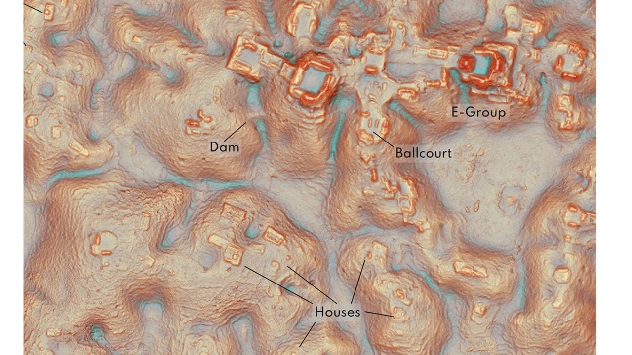
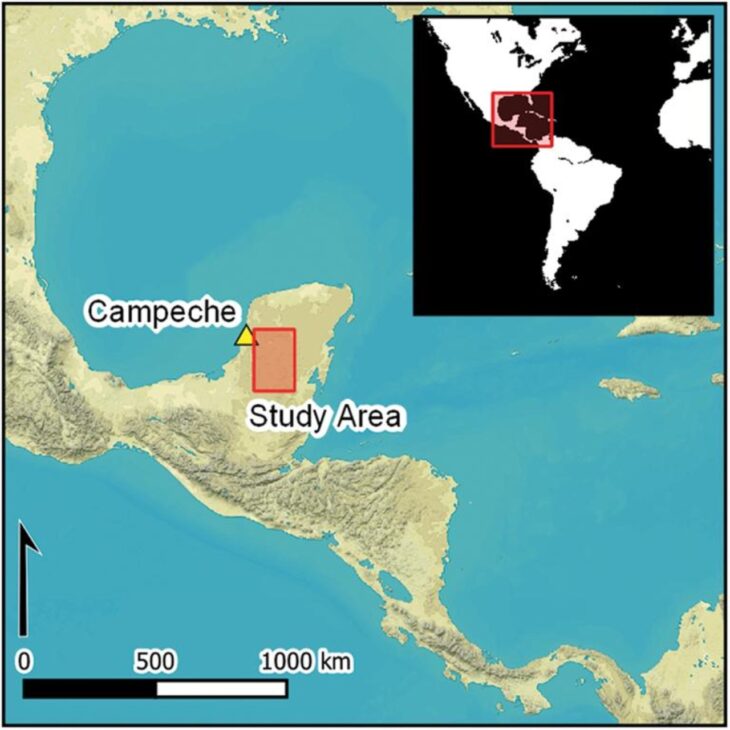
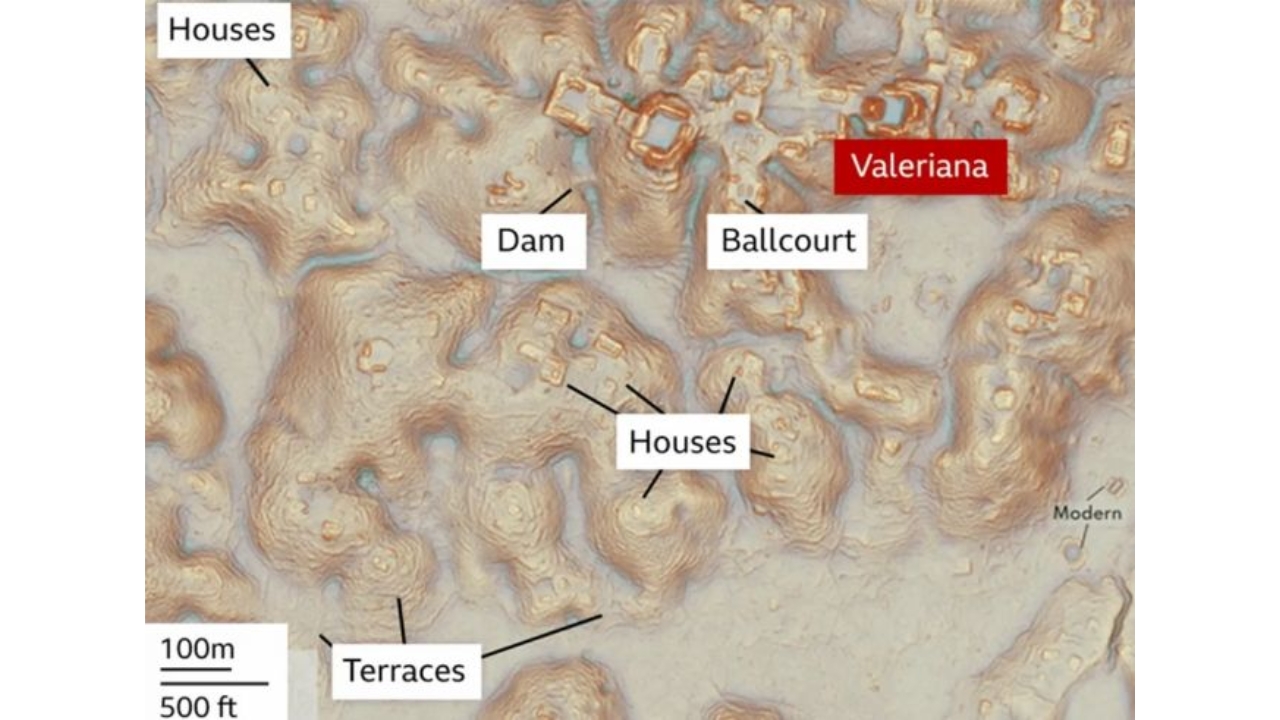
The city was named Valeriana, in reference to a nearby lagoon, and is located in the state of Campeche, in southern Mexico. The region is covered by dense vegetation and belongs to an area historically linked to ancient Mayan civilizations.
What makes the case even more impressive is that the discovery did not happen after years of excavations. It began with a common internet search. Auld-Thomas was looking for public data when he found a seemingly forgotten set of information, hidden deep in Google’s results.
As the files were processed, the invisible landscape began to appear. Where there was once only forest, the maps revealed more than 6,500 ancient structures, forming an urban complex that could have been a Mayan political capital during the Classic period.
LiDAR showed what the eyes could not see
The technology digitally removed the forest
LiDAR works by firing laser pulses from aircraft. These pulses pass through gaps in the vegetation and return to the equipment, allowing for the creation of extremely detailed models of the terrain. With this, researchers can digitally “remove” the trees and see the real shape of the ground.
This is exactly what happened in Campeche. The forest hid shapes that, seen from above, appeared to be just dense thicket. But in the digital models, rectangular platforms, ceremonial plazas, temple pyramids, agricultural terraces, reservoirs, and even a possible dam emerged.
This technology has changed archaeology because it allows for the discovery of structures that could go unnoticed for centuries. In tropical areas, where vegetation quickly covers ancient constructions, LiDAR has become a decisive tool for revealing entire cities without destroying the environment.
More than 6,500 structures were hidden in Mexico
The survey analyzed covered an area of approximately 122 km². Within this space, researchers identified a much denser occupation than previously imagined. The scenario reinforces an increasingly accepted idea: many regions seen as “empty” may actually hide deeply occupied ancient landscapes.
The city of Valeriana would have two main monumental areas. In one of them, typical features of a large Mayan city appeared: connected plazas, pyramids, ball game court, water reservoirs, and residential complexes.
These elements indicate that it was not a small or isolated settlement. The pattern of the structures suggests an organized city with political, religious, and social functions. For specialists, Valeriana may change the understanding of the population density and urbanization of the Mayan lowlands.
The city was near modern areas but went unnoticed
One of the most intriguing details is that the city was not in a completely inaccessible location. According to researchers involved in the study, part of the structures was relatively close to a road and areas where people circulated or cultivated.
This shows how a large ancient city can remain invisible even when it is near the modern world. Without laser mapping, the ruins would continue to appear as mere irregularities in the terrain covered by the forest.
The story also reveals a fascinating point: the find was not just hidden in the jungle. It was also hidden in a database. The lost city only appeared because someone decided to take a closer look at an old file, forgotten among little-accessed internet results.
Old data can hide new cities
The case of Valeriana raises a powerful possibility: there may be other environmental, forestry, or geographical surveys already conducted that hold signs of ancient cities not yet recognized. In other words, some future archaeological discoveries may already be available in digital archives, waiting for someone to look at them the right way.
This is one of the strongest parts of the discovery. It was not just a Mayan city that appeared. It was also a new way to find the past: using open data, laser technology, digital research, and archaeological analysis.
The ancient Mayan civilization is already known for its monumental cities, astronomical knowledge, agricultural systems, and impressive architecture. But Valeriana reinforces that the map of this ancient world is still incomplete.


