
 Portuguese
  Spanish
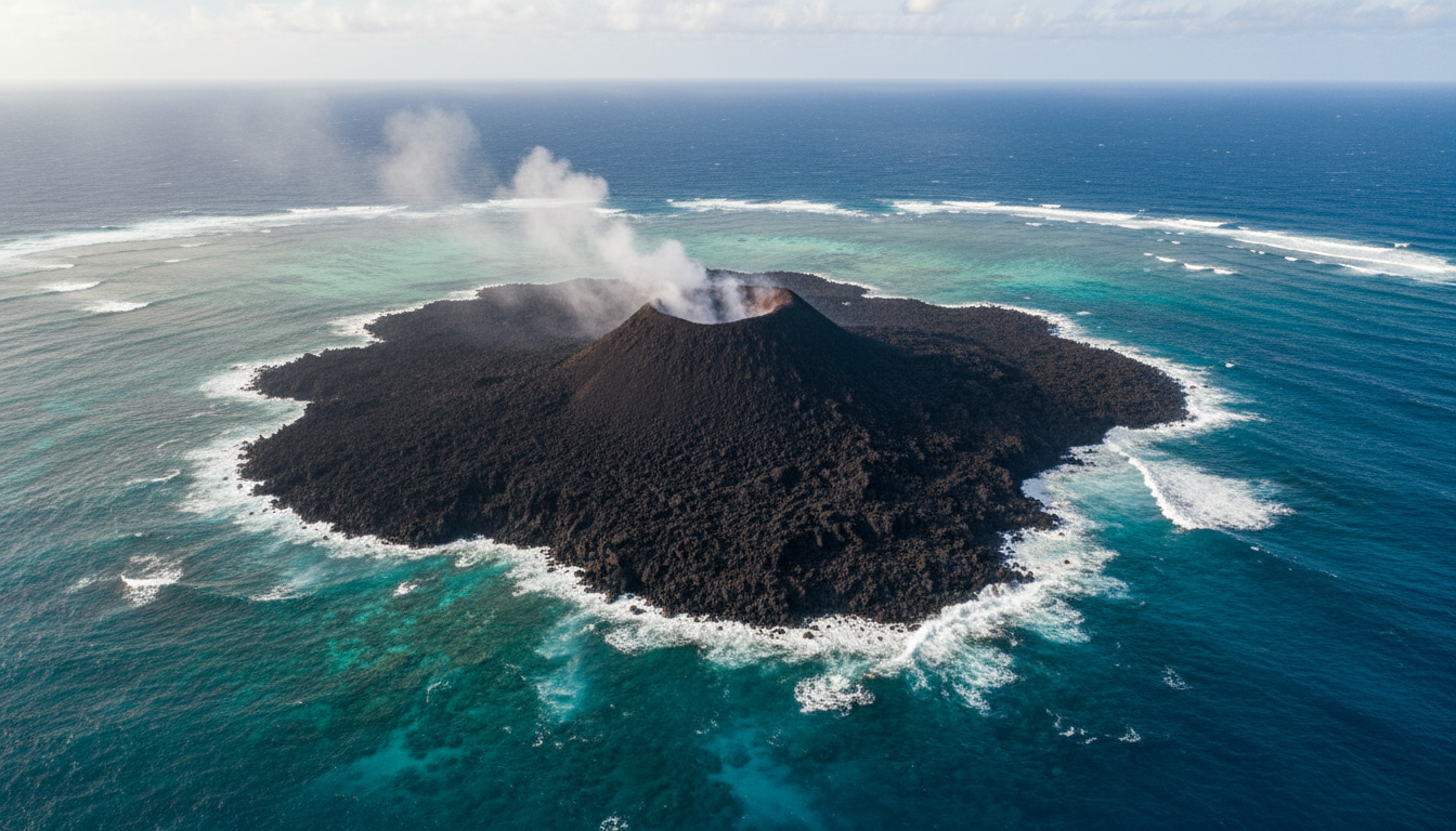
Continuous eruption since December 17, 2025, expanded island from 3 ha in 2022 to 26 ha in February 2026
The Home Reef Tonga volcano has been erupting for almost 5 months. The island it created in the South Pacific has grown 9 times since 2022 and now covers 26 hectares.
The most recent eruption began on December 17, 2025. The data was confirmed by NASA’s MODIS and VIIRS sensors.
According to the NASA Earth Observatory, the current phase expanded the island by an additional 8 hectares between December 2025 and February 2026 alone.
-
Wyoming Couple Grows Tropical Fruits Year-Round in -40°C Using Geothermal Greenhouse, Demonstrating Earth’s Heat Can Produce Oranges and Lemons in Snow Without Traditional Heating

-
11-Year-Old Entrepreneur Sells 60 Homemade Sweets Daily, Mastering Cost Calculation, Social Media Promotion, and Client Negotiation Since Age 7
-
Peruvian Mountain’s 5,200 Aligned Holes May Unveil Ancient Indigenous Market for Corn and Cotton
-
Ship Returns from Brazilian Coast with Thirty Newly Discovered Life Forms


This volume is equivalent to 15 American football fields. The measurement used images from the German Aerospace Center’s TerraSAR-X radar.
Simon Plank, a researcher at the DLR’s Earth observation unit, documented the directional growth. As Plank reported in February 2026, “lava flows extended east and south, then northwest, and later northward.”
Thus, the Home Reef Tonga volcano became the most detailed documented case of continuous island construction by underwater volcanic activity in recent decades.

Where the Home Reef Tonga volcano is located in the South Pacific
The Home Reef Tonga volcano is located between Metis Shoal and Late islands, in the central archipelago of the country. The exact coordinates are 18.99°S and 174.77°W.
Therefore, it is part of the Tonga-Kermadec subduction zone. According to NASA, this is “the world’s fastest tectonic convergence boundary.”
In this region, three tectonic plates collide at high speed. The process creates a constant flow of magma that feeds underwater volcanoes.
According to the Smithsonian Global Volcanism Program, the volcano has been monitored for decades. There are records of eruptions since 1852.
In fact, the historical average is one eruption every 24.7 years. But the current pace shows more frequent cycles.
Meanwhile, the region is also neighboring the Hunga Tonga-Hunga Ha’apai volcano. That one exploded in 2022 and generated a tsunami that reached Japan.

How the current eruption of the Home Reef Tonga volcano evolved
The current eruption began on December 17, 2025. In January 2026, Tonga Geological Services raised the aviation alert code to ORANGE.
As reported by Matangi Tonga on January 31, “volcanic activity remains ongoing, with volcanic gas, steam, and smoke rising from the main vent.”
Therefore, commercial pilots and residents of Vava’u reported an increase in the height of emissions. Some plumes reach altitudes of 600 meters.
According to satellite images analyzed by the Smithsonian Global Volcanism Program, multiple lava lobes advance in different directions.
The flows to the east and southeast entered the ocean and extended the coastline. The flows to the northwest expanded the coast by about 100 meters.
Thus, the island changed shape several times in a few months. In April 2026, activity reduced to a low level according to the Smithsonian.
Even so, the main vent continues to emit gas and steam. The eruption has not been officially declared over.

Technical data of the Home Reef Tonga volcano
The Home Reef Tonga volcano has a height of 70 meters above sea level. The diameter of the emerging island exceeded 1 kilometer.
Therefore, it is one of the largest recent emerging bodies in the South Pacific. Similar volcanoes usually erode in months or years due to wave action.
According to data from November 2025 visited by volcanologists in situ, the island was 12.2 hectares. By June 2024 it was also recorded at 12.2 hectares.
Thus, the growth between December 2024 and January 2025 was an additional 3.7 hectares. The growth from December 2025 to February 2026 was another 8 hectares.
According to analysis by The Watchers, the directional growth indicates typical basaltic flows. This is different from explosive eruptions that destroyed islands in the past.
- Start of current eruption: December 17, 2025
- Island growth: 3 ha (2022) → 26 ha (Feb/2026) = 9x more
- Emergent height: 70 meters above sea
- Diameter: more than 1 km
- Historical average cycle: 24.7 years between eruptions
- Location: 18.99°S 174.77°W (between Metis Shoal and Late Island)
Risks for aviation, fishing, and inhabited islands
Despite the continuous activity, the risk to inhabited islands is low. NASA Earth Observatory classifies the current eruption as “comparatively mild.”
According to Tonga Geological Services, authorities state that “there is no direct threat to populated islands like Vava’u and Ha’apai.” These are tens of kilometers from the main vent.
Therefore, the ORANGE aviation code only applies to local flight routes. Occasional ash plumes may compromise regional air navigation.
Meanwhile, fishing in the region has been temporarily restricted. Areas near the island may have toxic waters due to emitted volcanic gases.
According to VolcanoDiscovery, the 1984 eruption produced floating pumice that spread for hundreds of kilometers. The current cycle has not reached that level.
For comparative coverage of other recent underwater volcanoes, check out the Click Petróleo e Gás coverage of the Kolumbo volcano in Greece.

Implications for the offshore oil, gas sector, and technology
The continuous monitoring of the Home Reef Tonga volcano uses technology that has direct application in the offshore sector. The same TerraSAR-X radars are used to detect deformation of platforms and pipelines.
Therefore, the Tonga case becomes a methodological reference for offshore industry monitoring. Operators like Equinor and Petrobras are studying these data.
Meanwhile, the volcanic region of Tonga has unexplored geothermal potential. According to UWI Seismic Research, such environments can generate continuous clean energy.
Indeed, volcanic risk management in offshore projects has gained importance. Platforms near underwater volcanoes need their own protocols.
According to analysis by University of Leeds, the energy released by underwater volcanoes per day could power an entire continent.
For other recent volcanology cases, it is worth reading the scientific coverage by Click Petróleo e Gás on ancient geological events.
It is worth noting that the Home Reef island may erode in the coming years. Waves and storms in the South Pacific tend to destroy these formations on a decadal scale.
Despite this, the current cycle has already produced enough scientific data for 20 years of volcanological research. Tonga becomes a world reference in the study of land construction by underwater eruption.


