Portuguese
  Spanish
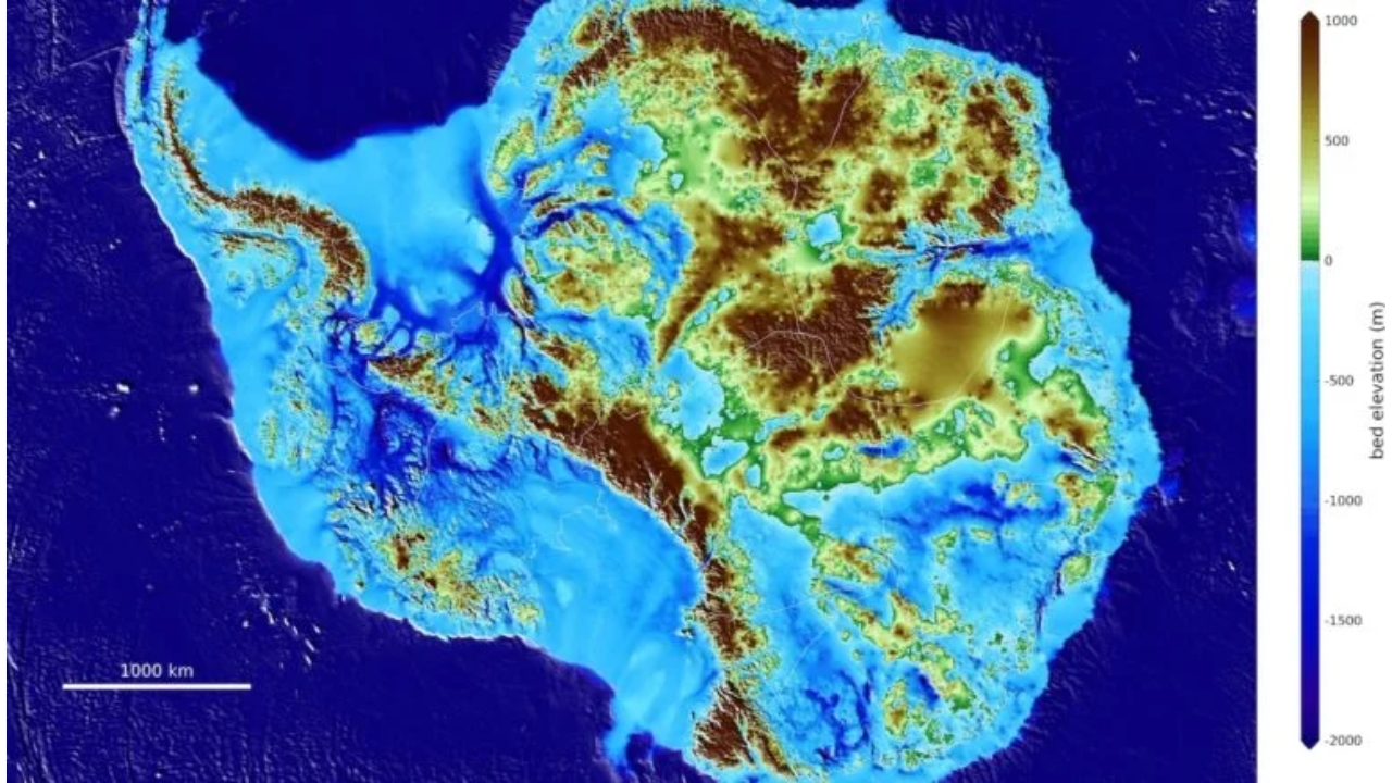
The Discovery Shows What Lies Beneath Kilometers of Ice and Helps Refine Climate Models About Ice Loss on the Continent
Antarctica has gained a subsurface map with a level of detail that changes the way we view the continent. The new perspective reveals what lies beneath kilometers of ice, with structures capable of influencing glacier behavior.
The Antarctic ice sheet covers a complex topography, with mountains, valleys, lakes, and large low-lying areas. Understanding these shapes is crucial for improving projections of melting and sea level rise.
Ice does not move on its own; it responds to what exists below. When the bedrock has channels and depressions, the flow can accelerate, change direction, and sculpt the surface in different ways.
-
16-Year-Old from Brazil’s Sertão Wins Young Scientist Award for AI Predicting Rainfall with 94.5% Accuracy to Aid Farmers

-
Netherlands Reports First Child Euthanasia Case Since Rule Expansion for Minors

-
Brazilian Innovator Survives Homemade Submarine Dive in Paraty Despite Hatch Leak and False Oxygen Alarm
-
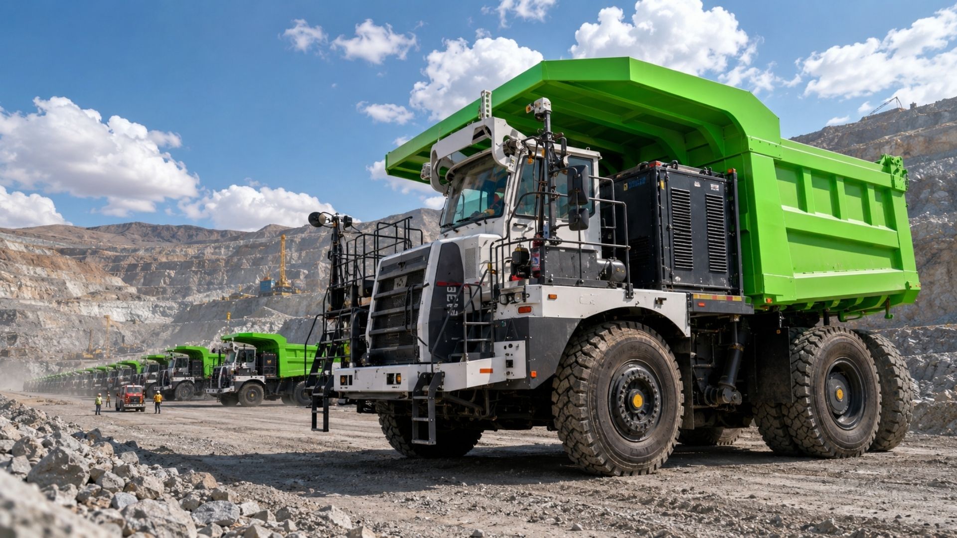
China Develops Custom 140-Ton Electric Mining Truck with 770 kWh Swappable Battery, Deploys 290 Units in Xinjiang’s Largest Zinc Mine


Map Shows What the Ice Hides and Exposes the “Engine” of the Glaciers


Scientists mapped the bedrock beneath the ice sheet with an unusual level of detail. The result reveals structures that were unclear or not accurately recognized.
The ice sheet extends over more than 5.4 million square miles (14 million square kilometers). This enormous covering hides the topography and complicates direct measurements.
With the underground terrain more defined, it becomes easier to understand why some regions accelerate ice flow while others behave differently.
Subsurface Topography Defines Where the Ice Flows and Where It Can Accelerate
The shapes of the terrain determine how the ice moves beneath and how the glacial surface is shaped over time. A clearer map of the subsurface improves the ability to predict future changes.
This type of information helps explain how the ice sheet has evolved and how it interacts with the bedrock.
The more detailed the topography, the more realistic the projections of ice melting and sea level rise become.
Gaps in Previous Measurements Hid Valleys That Guide Ice Flow
For a long time, much of what exists beneath the ice remained uncertain. Ground and aerial studies in the region are difficult, costly, and do not cover everything evenly.
Many measurements are restricted to distant points or are distributed unevenly. This can leave out valleys in the bedrock that function as natural “corridors” for ice.
When these details do not appear, models can misjudge the actual path of ice flow.
Satellites, Ice Thickness, and Flow Physics Created a Continental Portrait
The mapping combined high-resolution satellite images of the surface, measurements of ice thickness, and an analysis of the flow based on the physics of ice movement over the bedrock.
This data was integrated to form a continental map of the topography beneath Antarctica. The result also fills in gaps between radar study lines.
The new design reveals hills, ridges, and even parts of mountain ranges with much more clarity.
River Channels and Deep Valleys Emerge Between 2 and 30 Kilometers Below the Ice
The map revealed structures between 2 and 30 kilometers (1.2 and 18.6 miles) beneath the ice sheet that were previously unclear. Among them are channels that extend for hundreds of miles and may be remnants of a landscape prior to the large ice sheet.
Strong transitions between high and low terrain also emerged, suggesting tectonic boundaries. In an area where aerial studies indicated an ancient river environment covered by ice, deep underground valleys were identified.
These elements help understand where the ice finds natural pathways and how the topography can direct its movement.
More Accurate Models Can Improve Sea Level Projections
With the subsurface better defined, ice sheet models can become more complete and reliable. This helps make projections of ice melting and sea level rise due to warming more accurate.
The advancement also allows for clearer observation of how different regions of the continent respond to climate changes.
The more realistic the representation of the hidden terrain, the greater the chance of reducing uncertainties about the future of Antarctic ice.
The New Subsurface Map of Antarctica exposes a landscape hidden by kilometers of ice and reveals structures that directly influence glacier flow.
With this information, projections about ice melting and its impact on sea level can gain more precision, helping to better understand what may happen to the continent in the coming decades.