
 Portuguese
  Spanish
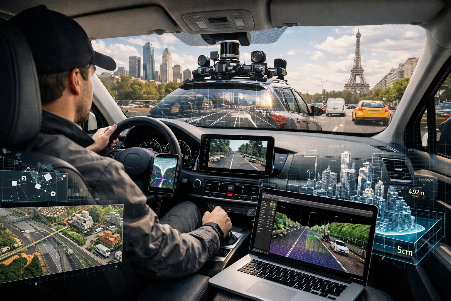
Every kilometer traveled by a driver equipped with sensors and cameras becomes raw material for extremely detailed digital maps used by assisted driving systems and autonomous vehicles.
In 2023, 2024, and 2025, technology and mobility companies intensified a model that is not very visible to the public: the use of ordinary drivers to collect advanced mapping data while driving on their daily routes. Reports from outlets like Bloomberg, The Verge and statements from companies like HERE Technologies and Nexar show that this system is already operating in various cities across the United States and Europe, integrating a global market that moves billions of dollars each year.
The logic is simple but powerful: every kilometer traveled by a driver equipped with sensors and cameras becomes raw material for extremely detailed digital maps, used by assisted driving systems and autonomous vehicles. These maps do not just show streets — they record lanes, pavement slope, sign positions, and even small irregularities in the roadway.
How ordinary drivers became part of the infrastructure of autonomous cars
Unlike the traditional image of dedicated mapping cars — like those used by Google — the new model distributes data collection across thousands of ordinary vehicles.
-
Banco do Brasil and Uber Launch Cashback Program Offering Up to 3.5 Loan Installments Back, Drivers Gain Access to New Cars Worth Up to $30,000 Through Move Brasil Initiative

-
Looking for a Car for Dirt Roads? Fiat Uno, Strada, and Volkswagen Gol Offer Durability and Affordability

-
MG Motor to Produce Two Electric Cars in Brazil with $75 Million Investment, Creating 600 Jobs
-
Nissan Kicks S Direct 2018: Affordable Used SUV with Over 13 km/l Fuel Efficiency, 432-Liter Trunk, and CVT Automatic Transmission


Companies like Nexar operate networks with hundreds of thousands of drivers using cameras installed on their windshields. These devices continuously record the urban environment while the driver goes about their normal routine. The captured data includes:
- Vertical and horizontal signage
- Traffic flow
- Changes in urban infrastructure
- Unexpected events, such as construction or blockages
Each trip becomes a map update, allowing the information to be constantly refreshed.

What are HD maps and why are they essential for autonomous vehicles
The so-called high-definition maps (HD maps) are different from traditional maps used in navigation apps. While common apps show streets and directions, HD maps operate at a millimeter or centimeter level, providing detailed data that allows the vehicle to understand the environment accurately.
Companies like HERE Technologies and TomTom develop these systems for applications in autonomous cars, advanced driver assistance systems (ADAS), and automated logistics. Accuracy can reach a few centimeters, allowing the vehicle to know exactly where it is within the lane.
Why these maps need to be constantly updated
Unlike traditional maps, which can remain static for months or years, the maps used by autonomous vehicles require continuous updates. Cities change every day. Construction alters routes, new signage is installed, lanes are modified, and temporary obstacles appear.
According to HERE Technologies, in some urban areas, maps need to be updated daily to maintain the reliability of advanced navigation systems.
This is why the model based on ordinary drivers has become essential. It allows for scale and constant updates without relying on limited fleets of specialized vehicles.
How much drivers earn and how the system works in practice
Payment varies depending on the company and the volume of data collected. In many cases, drivers are compensated for:
- Time using the system
- Amount of data sent
- Coverage of specific areas
The devices used can range from simple cameras connected to smartphones to more advanced systems with integrated sensors. The key point is that the driver does not need to change their routine. They continue to drive normally while the system collects data in the background.
A billion-dollar market that grows along with autonomous cars
The mapping market for autonomous vehicles is considered one of the foundations of future mobility. With the expansion of autonomous driving technologies and advanced assistance, the demand for accurate data is growing rapidly.
Companies in the automotive, technology, and mobility sectors are investing billions in the development and maintenance of these maps, which are seen as critical infrastructure for the operation of autonomous systems. Without detailed and updated maps, autonomous cars simply cannot operate safely.
Why this model could redefine the future of digital work
The use of ordinary drivers for data collection creates a new category of economic activity. It is not about transportation, delivery, or traditional apps. It is about transforming everyday commutes into data production.

This model expands the concept of digital work, bringing it closer to the so-called data economy, where common activities gain economic value when converted into information.
The invisible infrastructure behind autonomy
While the public debate about autonomous cars often focuses on sensors, artificial intelligence, and futuristic vehicles, there is a less visible but equally essential layer: the data. High-precision maps are the foundation upon which these systems operate.
And increasingly, these maps are being built not by isolated machines, but by thousands of anonymous drivers who, without altering their routines, help build the digital infrastructure of cities.
It is this invisible network of data collection that is allowing the cars of the future to learn to navigate the real world — one kilometer at a time.


