Portuguese
  Spanish
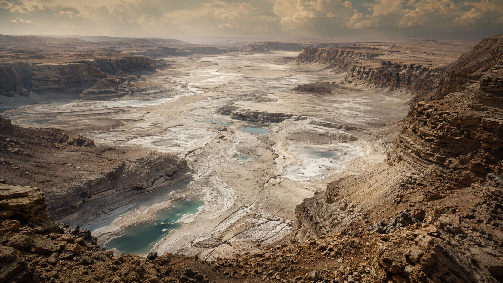
Study revisits the Mediterranean salinity crisis, when the sea dried up 5.96 million years ago, turned into a desert, and accumulated a colossal layer of salt at the bottom.
According to Knowable Magazine, on October 6, 1970 the scientific ship Glomar Challenger returned to Lisbon after drilling the bottom of the Mediterranean Sea at 28 points during the Leg 13 of the Deep Sea Drilling Program. Right at the first location, the drill struck an extremely hard layer 200 meters below the seabed, and scientists found gravel with marine fossils mixed with gypsum crystals, an evaporite rock that forms when water evaporates.
The discovery pointed to a radical conclusion. At some point in the past, the Mediterranean ceased to exist as a continuous sea and was replaced by an extreme landscape of salt, gypsum, and deeply lowered basins. This is the basis of the so-called Messinian Salinity Crisis, one of the most dramatic geological events ever identified on Earth.
Mediterranean salinity crisis began when Gibraltar closed
According to Knowable Magazine, the logic of the Mediterranean is simple. The sea evaporates more water than it receives from rain and rivers, with an annual deficit of about 3,300 cubic kilometers, compensated by the inflow of water from the Atlantic through the Strait of Gibraltar. Without this flow, the Mediterranean dries up.
-
He has never read a line of code, but he already knows how to work: the French company UMA presented in Paris the Northstar, its first AI-powered humanoid robot designed for factories and warehouses, capable of copying tasks just by observing an employee in action.

-
A young Kenyan engineer collects plastic waste from the streets and transforms it into robots that translate physics lessons into sign language in real-time, a machine made with old bottles that teaches what was missing to deaf children left out of science.

-
What is the dark substance found in the sand of Ipanema Beach? Civil Police conduct an examination, collect samples of the material, and initiate an investigation to identify the composition, clarify the origin, and verify if there was an environmental crime.
-
The beer that was hidden for 3,000 years has returned to the world: scientists find yeast preserved in Ancient Egyptian vessels and recreate a pharaoh’s drink to discover the lost taste of an ancient civilization.


With an approximate volume of 3.7 million cubic kilometers, the sea could evaporate in just over a thousand years in this scenario. This is what happened 5.96 million years ago, when tectonic movements related to the collision between the African and Eurasian plates closed the connection with the Atlantic.
In less than a thousand years, what was once an inland sea of 2.5 million square kilometers turned into a desert of salt and gypsum, located between 2 and 4 kilometers below global sea level, one of the most extreme landscapes ever produced on the Earth’s surface.
Glomar Challenger found salt, gypsum, and drying cracks on the Mediterranean sea floor
At each new drilling point, researchers found the same pattern. According to Knowable Magazine, gypsum, anhydrite, halite, and potassium and magnesium chlorides appeared, minerals typical of environments where water evaporates almost completely.
In some cores, the team identified drying cracks, similar to those that appear today in dry lakes. In another, a layer of marine sediment turned to dust and deposited by the wind appeared between layers of halite, indicating that parts of the seabed were exposed to air and aridity.
The oxygen isotopes in marine shells showed that these organisms lived in a brine from which 90% of the original water had already evaporated. It was the record of a sea in chemical and physical collapse.
Mediterranean salt giant holds 10% of all ocean salt
The layer drilled by the Glomar Challenger became known as the Mediterranean salt giant. According to Knowable Magazine, it averages 1 kilometer in thickness, covers about 2.5 million square kilometers, and in the deepest basins, can reach 1.8 kilometers.

The most impressive fact is that this structure retains about 10% of all the salt in the planet’s oceans. This shows the global scale of the event. When the Mediterranean dried up, it removed one-tenth of the total marine salt stock from circulation.
It is not just a regional detail of European geology. The Messinian Salinity Crisis was an event capable of altering ocean chemistry, global sea level, and hydrological dynamics on a planetary scale.
Dry Mediterranean turned into desert valley up to 4 kilometers below sea level
Imagining the dry Mediterranean requires abandoning the current geography. According to Knowable Magazine, the bottom of the deepest basins was between 2 and 4 kilometers below the global sea level, forming a continental valley with no direct modern equivalent.
In an arid and deeply enclosed environment, temperatures would have been extreme. The publication compares the scenario to the Afar desert in Ethiopia, where the surface already reaches 60°C. In a much deeper valley surrounded by rocky walls, the heat would likely have been incompatible with the prolonged presence of terrestrial animals.
The large rivers flowing into the Mediterranean also responded to the collapse. Nile, Rhône, and Ebro carved gigantic canyons following the continuous drop in the base level, including a Nile canyon estimated at 3 to 4 kilometers below the current sea level.
Salinity crisis had cycles of evaporation, partial flooding, and Lago Mare
According to Knowable Magazine, the event was not a single, linear evaporation of 630 thousand years. Paleomagnetic datings indicate that the crisis began almost simultaneously throughout the basin at 5.96 ± 0.02 million years.
The early stages, between 5.96 and 5.6 million years ago, produced partial evaporation and deposition of gypsum and carbonates. At 5.6 million years, the definitive closure of the strait and the arid climate accelerated the collapse. Then, between 5.5 and 5.33 million years, there were cyclical phases of extreme salinity and partial dilution.

During this interval, the episode called Lago Mare appeared, when the Mediterranean seems to have received an influx of fresh water from the Paratethys basin. The evaporite layers alternate with fossils of freshwater or brackish species, indicating repeated oscillations between desiccation and partial refilling.
Zanclean Flood may not have been the megaflood imagined for decades
At 5.33 million years, the tectonic barrier that isolated the Mediterranean gave way and the Atlantic returned to enter. For decades, the dominant hypothesis described this event as the Zanclean Flood, a catastrophic flood where Gibraltar would have functioned as a colossal waterfall and the sea would fill in less than two years.
But Knowable Magazine itself, in a review published in March 2026, states that the most recent geological evidence suggests a more gradual filling than the classic version proposes. The Atlantic entry may have combined with an influx of fresh water from the east and a rise in global sea level.
This does not eliminate the possibility of a large influx of water through Gibraltar, but it weakens the image of the instant megaflood that has dominated scientific and popular imagination for more than half a century.
What geology still doesn’t know about the Mediterranean that dried up
Knowable Magazine highlights that there are still three major open questions. The first is the exact mechanism that closed the connection with the Atlantic. Plate tectonics is the dominant explanation, but the precise sequence of faults, uplifts, and blockages is still under study.
The second question is the actual depth of the desiccation. The classical hypothesis proposed almost total drying, but more recent research suggests that parts of the abyssal basins may have maintained a deep hypersaline brine, which would indicate an intermediate scenario between sea and absolute desert.
The third question is the most uncomfortable for the present. According to the publication, the geological answer is yes, in principle: the Mediterranean could dry up again in some geological future, because the African and Eurasian plates continue to narrow Gibraltar. The difference is that next time, there will be cities, ports, and human infrastructure throughout the basin.