
 Portuguese
  Spanish
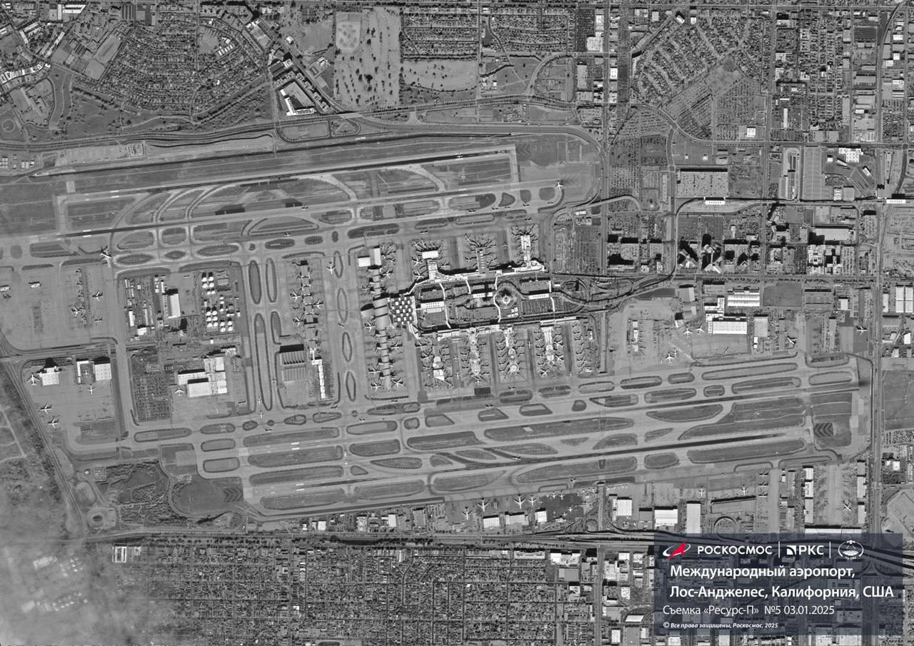
The Russian Spy Satellite Reveals High-Resolution Images of the United States and Exposes Strategic Bases with Impressive Accuracy. Advanced Technology That Redefines Global Military Surveillance
On March 31 last year, the Russian rocket Soyuz-2.1b launched the new spy satellite Resurs-P into space. Nine months later, on January 3, 2025, Roscosmos published the first images and capabilities of the Geoton-L1 equipment, the main instrument for observing the Earth’s surface with high spatial resolution.
Roscosmos released four images: two from Los Angeles (USA) and two of the Burj Khalifa complex in Dubai (UAE). These images effectively disprove skeptical claims that the Geoton-L1 could not capture high-resolution photos, as the images shared by Roscosmos are indeed impressive.
Russian Satellite Technology for Surveillance and Strategic Monitoring
The image of Los Angeles released by Roscosmos captured in detail the SoFi Stadium, located in the Inglewood neighborhood, where two teams from the National Football League (NFL) play: the Los Angeles Rams and the Los Angeles Chargers.
-
Helicopter Drops 180 Tons of Sand and Gravel on Swedish River to Revive Ecosystem Damaged by Decades of Exploitation

-
Brazilian Company Launches Retro Smartphone with 48 MP Camera, T9 Keyboard, and Privacy Features for Social Media-Free Use

-
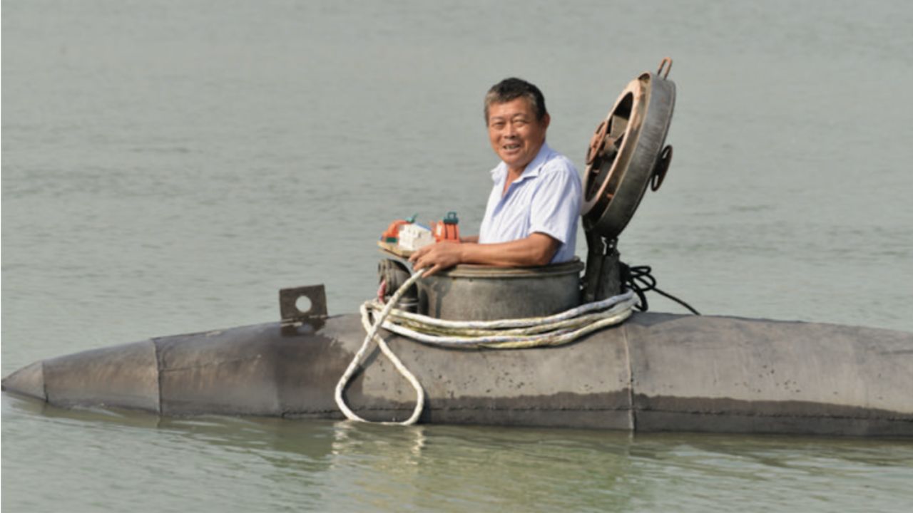
Self-Taught Chinese Farmer Builds 5-Ton Submarine from Scrap, Launches It in Anhui River
-
Invisible Induction Technology Enables Wireless Power for Blenders, Coffee Makers, and Air Fryers, Reducing Countertop Cables


The SoFi Stadium also hosts other sporting events, such as American football games, concerts, and major events like the Super Bowl and performances by world-renowned artists. The facility is modern and offers various entertainment options.
The spy satellite Resurs-P and the Geoton-L1 are Russian high-resolution technologies designed for remote sensing and data collection about the Earth’s surface. This technology is part of Russia’s efforts to strengthen its intelligence and strategic surveillance capabilities, providing images with impressive accuracy and detail.
The system is crucial for monitoring military sites, critical infrastructure, and natural resources, making it extremely important for Russian geopolitical interests. With its ability to capture high-resolution images, the Geoton-L1 is a useful tool for both military purposes and monitoring climate change or tracking natural disasters.
These satellite systems offer a strategic advantage, allowing Russia to observe accurately and respond in real time to the information received. The ability to collect this data provides Moscow with the necessary tools to analyze the state of various critical objects and make informed decisions in intelligence and military operations.
The Geoton-L1 is part of Russia’s satellite infrastructure designed to enhance national security and maintain control over strategically important regions. The power of the system plays a vital role in modern conflicts and geopolitical tensions, giving Russia the capability to monitor and rapidly assess critical situations for its national security.
Certainly, greater emphasis should be placed on the Geoton-L1 equipment, as it is the main agent in surveillance and espionage. As a high-resolution satellite system, the Geoton-L1 plays a crucial role in Russia’s contemporary military strategy, especially in the context of the war with the United States and conflicts in Europe, such as the war in Ukraine and NATO’s mobilization.
The technology enables surveillance and detailed analysis of military and strategic targets on the Earth’s surface, providing Russia with the necessary data for operational decisions and tactical actions. Satellites like the Geoton-L1 allow for the detection of military movements, assessment of war resources, and gaining insights into enemy forces.
The Role of Satellites in Defense Against the United States and NATO
In the event of war with the United States, the Geoton-L1 would give Russia the capability to monitor and analyze the most critical military and strategic targets of American forces.
High-resolution satellites can capture and analyze in detail strategic military locations, such as military bases and critical infrastructures. The Geoton-L1 could provide accurate images of American military bases located at strategic points in the United States and around the world.
The ability to monitor infrastructures such as ammunition depots, command centers, missile facilities, and other strategic targets provides Russia with valuable information for attacking key points. Additionally, the satellite can detect construction or logistics activities at these bases, providing clues about potential military operations.
The satellite technology would also allow monitoring of key military transport corridors that the United States could use to move troops and equipment in the event of military action.

The detection of military convoys, troops crossing strategic points, or military airfields would allow Russia to predict and calculate potential attack or mobilization points.
The Geoton-L1 could also be used to monitor nuclear arsenals, medium-range missiles, strategic submarines, and bombers. The ability to detect the construction or movement of strategic weapons provides Russia with information about potential U.S. attacks, enabling countermeasures to be taken.
The system can detect and analyze movements of American mobile military units, including tank divisions, warships, and aircraft, allowing Russia to predict potential threats and organize tactical counterattacks.
Military Monitoring in Ukraine and the United States: Real-Time Analysis and Strategy
The Geoton-L1 could also play a role in strategic cyber intelligence. By monitoring communication networks and satellite links, Russia could track American efforts in cyber warfare operations.
The detection of signals and communications in real time could open opportunities to neutralize or disrupt critical communication channels of the U.S.
The Geoton-L1 would also be crucial in the context of the conflict in Ukraine and the relations between Russia and NATO. The capability to analyze and monitor NATO troop movements in Europe is important for Russia, allowing for strategic planning and countermeasures in the face of any aggression.
High-resolution satellites can be used to observe the positioning of NATO troops near Russian borders, monitor military maneuvers, construction of new bases, and distribution of combat units and equipment.
The Geoton-L1 can detect and document any new phase in NATO’s military presence, allowing Russia to assess the resources needed for defense or counter-offensive actions.
NATO troops positioned in Eastern Europe and Ukraine rely on regular supplies of fuel, ammunition, food, and other logistical resources.
The Geoton-L1 can track these shipments, as well as the logistical routes used, enabling Russia to anticipate and potentially strike critical networks to weaken NATO operations.
By monitoring NATO’s military maneuvers in the region, the Geoton-L1 can provide data on the number of deployed troops, the equipment used, and the adoption of new technologies or tactics.
Monitoring NATO joint exercises can also help Russia adjust its military strategies and prepare for a response if the conflict escalates.
Satellites like the Geoton-L1 can track all movements of troops and military equipment in Ukraine, including the arrival of reinforcements from NATO or other Western countries.
These satellites can also monitor the transport of ammunition, equipment, and resources, offering Russia a comprehensive view of the support received by the Ukrainian army.

The Geoton-L1 could also track critical infrastructures, such as power plants, water supply networks, and transportation centers, which are vital for Ukraine and NATO.
Knowing the location of these structures, Russia could plan precise attacks to disrupt enemy logistical networks and hinder NATO operations.
Geographically, NATO has a wide variety of military structures and resources across Europe.
The Geoton-L1 can be used to detect new bases, training centers, or strategic positions in Europe established by NATO to strengthen its presence against Russia.
The satellite system could also monitor all steps involved in the construction or expansion of these positions.
The Geoton-L1 is capable of providing extremely valuable data on the movements of aerial and naval platforms used by NATO in the region. This includes tracking aircraft, combat helicopters, warships, and submarines, as well as detecting new transfers of strategic resources.
With this, Russia would have the capacity to react and plan strategic attacks.
The Geoton-L1 provides Russia with a strategic advantage by allowing the monitoring and analysis, in real time, of enemy movements both in the United States and in Europe. This provides the Kremlin with vital data to plan tactics, attacks, and countermeasures — something crucial in the context of modern warfare.


-

-

2 people reacted to this.