Portuguese
  Spanish


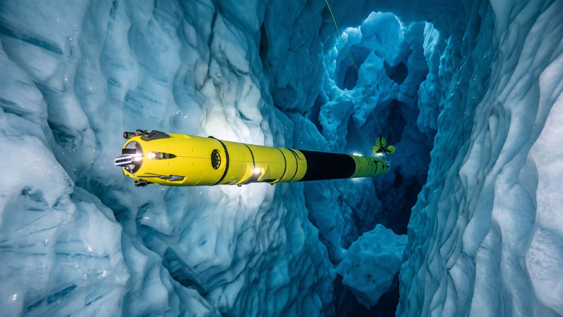


Icefin robot revealed accelerated melting in crevices under the Thwaites Glacier, which could raise sea levels by 65 cm.
A narrow, elongated underwater robot designed to enter through ice holes has revealed one of the most detailed images ever obtained of the underside of the Thwaites Glacier in West Antarctica. Called Icefin, the vehicle was launched through a hole about 600 meters deep, opened with hot water, reaching a region that satellites, ships, and divers cannot directly observe. Thwaites is known in international reports as the “doomsday glacier” because of the long-term risk associated with its collapse. According to the International Thwaites Glacier Collaboration, if the entire glacier were to collapse, the global average sea level would rise by about 65 cm, or 25 inches.
The most surprising finding was not just the presence of warm water under the ice, but how it acts. Studies published in Nature showed that flat parts of the base melted less than some models expected, while crevices, sloped walls, and step formations concentrated much faster melting.
Icefin robot entered through a 600-meter hole to reach the zone where the glacier meets the ocean
Icefin was used within the MELT project, part of the UK–US scientific collaboration that studied Thwaites. The team opened access by drilling with hot water on the ice shelf and lowered the robot into the ocean cavity under the glacier.
-
She spent 73 years breathing inside an iron lung, survived the aftereffects of polio, and became the last woman in the United States dependent on the equipment before dying at 78 years old.

-
Brazilian students created a $1 filter using pine bark, cotton, and 3D-printed parts to clean cassava wastewater, reduce the toxicity of a hazardous waste, and transform contaminated water into biofertilizer.

-
Astronaut from Artemis II steps down after mission to the Moon and decision surprises after a record of 406,771 km, a historic 10-day journey, and an unprecedented achievement for Canada.

-
A fossil kept for years in a small museum in Montreal concealed 450-million-year-old soft tissue, a discovery that has only happened once before in history.


The operation took place near the so-called grounding line, the point where the ice stops touching the seabed and begins to float as an ice shelf. This region is critical because it controls the glacier’s stability and the speed at which continental ice can advance into the ocean.
The Nature article reports that the observations were made through a hole penetrating 587 meters of ice, approximately 1.5 to 2 km from the current grounding line. The BAS public description summarizes the operation as a hole about 600 meters.
3.5-meter vehicle carried cameras, sonar, and sensors to a place where no human can reach
The Icefin is 3.5 meters long, 23 cm in diameter, weighs 130 kg, and was designed to operate at depths of up to 1 km. Its narrow shape allows it to pass through vertical ice holes while carrying oceanographic sensors, cameras, and navigation systems.


The platform carries high-definition cameras, sonar, temperature and salinity sensors, dissolved oxygen, pH, turbidity, altimeter, seabed imaging systems, and instruments to measure currents. This transforms the robot into a kind of mobile laboratory under the ice.
During the mission at Thwaites, the Icefin measured temperature, salinity, dissolved oxygen, and current speeds, as well as mapped the seafloor and ice base in three dimensions.
Crevasses and terraces under the ice melt much faster than flat areas
The central finding is that Thwaites does not melt uniformly from below. In the flatter areas of the platform’s base, a layer of cooler water helps reduce vertical heat mixing and limits the melt rate.
Even so, the Icefin showed that the ice base has crevasses, sloped walls, and step-like structures, where warm water can attack the ice more intensely. The ITGC states that in these areas, rapid melting is occurring even when the average rate under flat parts seems lower.
The British Antarctic Survey reported that over nine months, the water near the grounding line became warmer and saltier, but the average melting at the ice base was between 2 and 5 meters per year, below what some models predicted. The problem is that this average number hides concentrated melting points in the crevasses.
Thwaites Glacier has retreated 14 km since the 1990s and remains out of balance
The Thwaites is one of the fastest-changing glaciers in Antarctica. According to the ITGC, its grounding zone has retreated 14 km since the late 1990s, indicating that the glacier’s base has been losing stability.

Nature describes Thwaites as a particularly vulnerable system because much of the ice is supported below sea level, on a bed that deepens inland. This geometry increases the risk of accelerated retreat when ocean water manages to reach the base of the glacier.
The article itself states that the complete collapse of Thwaites, over centuries, would contribute 65 cm to global sea level. The broader destabilization of major glaciers in the Amundsen Sea sector would have much greater potential, reaching several meters over longer time scales.
Two studies in Nature changed the way of viewing the melting under Thwaites
The results were published in two scientific articles in the journal Nature in February 2023. One of them analyzed the suppressed basal melting in the grounding zone of the eastern Thwaites platform; the other described the heterogeneous melting near the grounding line with data from Icefin.
The major change is that scientists began to see the base of the glacier as an irregular environment, with concentrated melting points, rather than a flat surface where ocean heat acts homogeneously.

Peter Washam, a researcher associated with the Icefin team, stated in a Cornell release that the robot collects data as close as possible to the ice, in places that no other tool can reach today. For him, the system is complex and requires rethinking how the ocean melts the ice in a region like Thwaites.
The threat is not only in the average melting, but in the cracks that weaken the structure
The most important data from the mission is that a lower average melting rate does not mean safety. ITGC itself states that despite suppressed melting in parts of the platform, the glacier continues to retreat.
The reason is that crevices and terraces act as weak points. When warm water enters these irregularities, it expands cracks, alters the base geometry, and helps weaken the platform that holds the continental ice.
In practice, Icefin showed that the danger of Thwaites cannot be measured only by a simple average of meters melted per year.
The problem lies in the combination of hot water, cracks, retreat of the grounding line, and the progressive loss of the platform’s ability to stop the ice coming from the continent.
Icefin reveals Antarctica’s blind spot that climate models are still trying to reach
Satellites can measure the height, speed, and surface change of glaciers. But they do not directly see what happens at the submerged ceiling of the ice shelves, where the ocean touches the base of Antarctica.
This is exactly the blind spot that Icefin began to reveal. The robot entered through a narrow hole, swam under hundreds of meters of ice, and showed that the invisible part of Thwaites is irregular, active, and more complex than simplified models could represent.
The mission’s message is direct: the threat of the “doomsday glacier” is not only in what appears by satellite. It is hidden in the crevices, steps, and submerged walls where hot water silently works against a mass of ice capable of reshaping the planet’s coastline.