
 Portuguese
  Spanish
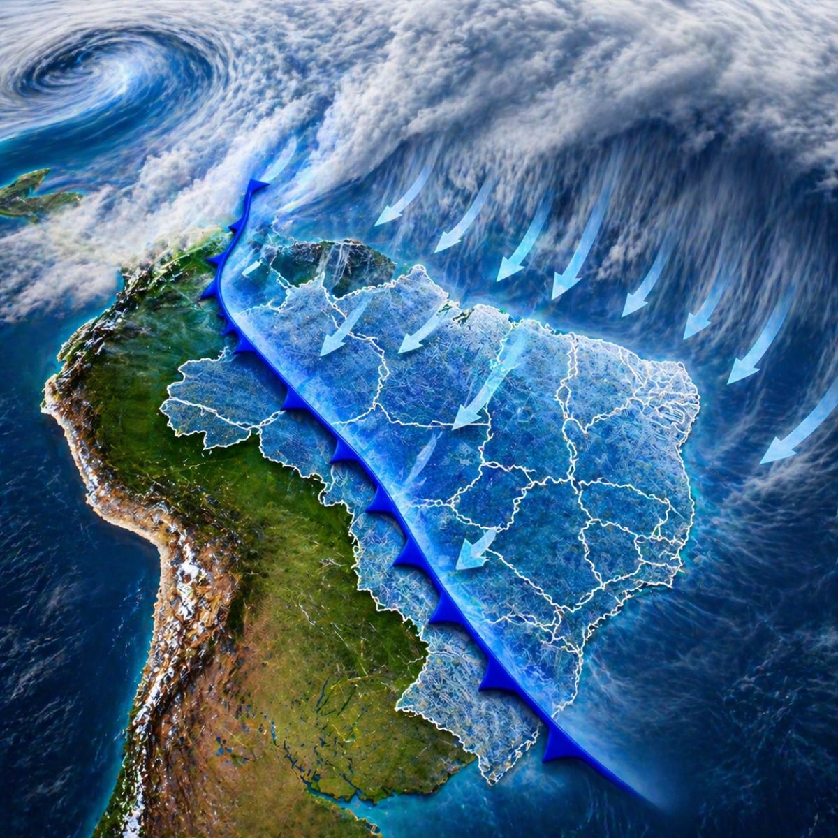
A colder air mass more intense than normal for April advances over Brazil between April 25 and 28, driven by an extratropical cyclone and an organized cold front. The South will be the most affected region, with minimums below 10°C at the peak of the cooling on Tuesday (28), and the cold should reach areas of the Southeast and Midwest in the following days.
After days of heat above expectations in much of the country, the cold air mass approaching Brazil promises a sharp turnaround in the weather starting next weekend. According to Meteored, the most significant change is expected to occur between April 25 and 26, when the system will be able to advance strongly over the South and begin to reach areas of the Southeast and Midwest. States like Rio Grande do Sul and Santa Catarina will be the first to feel the drop in temperatures and the increase in rainfall frequency with potential for high volumes.
The entry of cold air will be driven by the formation of a low-pressure area and the advance of a more organized cold front than those that hit the country in previous weeks. An extratropical cyclone acting south of Uruguay will help channel colder winds towards Brazilian territory, accelerating the movement of the cold air mass and expanding its geographical reach. The peak of the cooling is expected on Tuesday (28), when thermometers may register minimums below 10°C in several cities in the South.
What will cause the arrival of the cold air mass in Brazil

According to information released by the portal ndmais, the mechanism that pushes the cold air mass towards Brazil combines three meteorological factors. The first is the formation of a low atmospheric pressure area, which acts as a motor pulling cold air from the higher latitudes of the continent northward. The second is the advance of a more organized and persistent cold front than those that passed in recent weeks, capable of sweeping the South from southwest to northeast more efficiently.
-
Oil Company Robots Discover 3,300-Year-Old Canaanite Shipwreck in the Mediterranean, Proving Ancient Mariners Navigated Open Seas Using Stars Long Before Historians Thought

-
Helicopter Drops 180 Tons of Sand and Gravel on Swedish River to Revive Ecosystem Damaged by Decades of Exploitation

-
Brazilian Company Launches Retro Smartphone with 48 MP Camera, T9 Keyboard, and Privacy Features for Social Media-Free Use

-
Self-Taught Chinese Farmer Builds 5-Ton Submarine from Scrap, Launches It in Anhui River


The third factor is the extratropical cyclone positioned south of Uruguay, which helps to channel cold winds and accelerate their entry into Brazilian territory. The combination of these three elements creates conditions for the cold air mass to advance with greater reach and intensity, affecting not only the extreme south but also areas further north that rarely feel the effects of polar systems in April.
How temperatures will be in the South between Friday and Tuesday
The change in weather will be gradual but noticeable. In Rio Grande do Sul, afternoon highs are expected to drop to around 25°C as early as Friday (25), with even lower values in the mountainous regions. During the night, temperatures are likely to fluctuate between 14°C and 16°C in the first few days, progressively decreasing as the cold air mass consolidates over the region.
The most intense moment of cooling occurs on Tuesday (28), when several cities in the South are expected to record lows below 10°C. Mountain regions, such as Serra Gaúcha and Serra Catarinense, may record even lower temperatures, with the possibility of values close to 5°C in the coldest mornings. The thermal sensation will be intensified by the wind, which is expected to remain moderate to strong throughout the period of the system’s influence.
The advance of cold to the Southeast and the Midwest
At the beginning of next week, the cold air mass will spread throughout the South region and reach the south of Mato Grosso do Sul, as well as areas in the south and east of São Paulo. Still, the cooling will not be uniform across the country. While the South records temperatures significantly lower, the Midwest and the Southeast may maintain high daytime maximums, driven by pre-frontal conditions, when warm winds precede the arrival of the cold front.
This dynamic creates significant thermal contrasts. A city in the interior of São Paulo may record a high of 30°C on Monday and drop to 18°C on Tuesday, as the cold front advances and polar air replaces the warm air mass. For the Midwest, the impact tends to be more moderate, with a drop in nighttime lows, but without the intensity observed in the South. Regions further north in the country are not expected to feel significant effects from this cold wave.
What to expect after the passage of the cold air mass
After the peak of cooling on Tuesday (28), the trend is for a gradual stabilization of temperatures throughout the following week. The cold air mass loses strength as it moves away from polar latitudes, and the sun will begin to shine more intensely again, especially in the South and Southeast. However, nighttime lows are expected to remain low for a few more days, as the dry air accompanying the polar system keeps the sky clear and favors rapid heat loss during the early morning.
For those living in the South, the recommendation is to prepare warm clothing and keep track of updates from meteorological agencies in the coming days. The combination of rain and cold in the first days of the transition may cause discomfort and require special attention for children, the elderly, and homeless individuals. The expected rains for Rio Grande do Sul and Santa Catarina before the definitive arrival of cold air deserve monitoring in areas with a history of high accumulations.
Are you prepared for the drop in temperature that is coming, or did the heat of the last few days catch you off guard? Tell us in the comments how the weather is in your city and if you have already felt any signs of the upcoming transition.
A colder air mass than usual for April is advancing over Brazil between April 25 and 28, driven by an extratropical cyclone and an organized cold front. The South will be the most affected region, with lows below 10°C at the peak of the cooling on Tuesday (28), and the cold is expected to reach areas of the Southeast and Midwest in the following days.
After days of heat above expectations in much of the country, the cold air mass approaching Brazil promises a sharp change in the weather starting next weekend. According to Meteored, the most significant change is expected to occur between April 25 and 26, when the system will be able to advance forcefully over the South and begin to affect areas of the Southeast and the Midwest. States like Rio Grande do Sul and Santa Catarina will be the first to feel the drop in temperatures and the increase in rainfall frequency with the potential for high volumes.
The entry of cold air will be driven by the formation of a low-pressure area and the advance of a more organized cold front than those that affected the country in previous weeks. An extratropical cyclone acting south of Uruguay will help channel colder winds towards Brazilian territory, accelerating the movement of the cold air mass and expanding its geographical reach. The peak of the cooling is expected on Tuesday (28), when thermometers may register lows below 10°C in several cities in the South.
What will cause the arrival of the cold air mass in Brazil
The mechanism that pushes the cold air mass towards Brazil combines three meteorological factors. The first is the formation of a low atmospheric pressure area, which acts as a motor pulling cold air from the higher latitudes of the continent northward. The second is the advance of a more organized and persistent cold front than those that passed in recent weeks, capable of sweeping the South from southwest to northeast more efficiently.
The third factor is the extratropical cyclone positioned south of Uruguay, which helps to channel the cold winds and accelerate their entry into Brazilian territory. The combination of these three elements creates conditions for the cold air mass to advance with greater breadth and intensity, affecting not only the extreme south but also areas further north that rarely feel the effects of polar systems in April.
How temperatures will be in the South between Friday and Tuesday
The change in weather will be gradual, but noticeable. In Rio Grande do Sul, afternoon highs are expected to drop to around 25°C as early as Friday (25), with even lower values in mountainous regions. During the night, thermometers tend to fluctuate between 14°C and 16°C in the first few days, progressively falling as the cold air mass consolidates over the region.
The most intense moment of the cooling occurs on Tuesday (28), when several cities in the South are expected to record lows below 10°C. Mountainous regions, such as Serra Gaúcha and Serra Catarinense, may register even lower temperatures, with the possibility of values close to 5°C on the coldest mornings. The wind, which is expected to remain moderate to strong throughout the system’s duration, will intensify the thermal sensation.
The advance of cold to the Southeast and Central-West
At the beginning of next week, the cold air mass will spread throughout the entire South region and reach southern Mato Grosso do Sul, as well as areas in southern and eastern São Paulo. However, the cooling will not be uniform across the country. While the South records significantly lower temperatures, the Central-West and Southeast may maintain high maximums during the day, driven by pre-frontal conditions, when warm winds precede the arrival of the cold front.
This dynamic creates expressive thermal contrasts. A city in the interior of São Paulo may record a high of 30°C on Monday and drop to 18°C on Tuesday, as the cold front advances and the polar air replaces the warm air mass. For the Central-West, the impact tends to be more moderate, with a drop in nighttime lows, but without the intensity observed in the South. Regions further north of the country are not expected to feel significant effects from this cold snap.
What to expect after the passage of the cold air mass
After the peak of cooling on Tuesday (28), the trend is for a gradual stabilization of temperatures throughout the following week. The cold air mass loses strength as it moves away from polar latitudes, and the sun returns with greater intensity, especially in the South and Southeast. However, nighttime lows should remain low for a few more days, as the dry air accompanying the polar system keeps the sky clear and favors rapid heat loss during the early morning.
For those living in the South, the recommendation is to prepare warm clothes and follow updates from meteorological agencies in the coming days. The combination of rain and cold in the first days of the turn of the week can cause discomfort and require special attention for children, the elderly, and homeless people. The rains forecast for Rio Grande do Sul and Santa Catarina before the definitive entry of cold air deserve monitoring in areas with a history of high accumulated rainfall.
Are you ready for the drop in temperature that is coming, or has the heat of the last few days caught you off guard? Let us know in the comments what the weather is like in your city and if you have already felt any signs of the upcoming change.


-

1 person reacted to this.