
 Portuguese
  Spanish
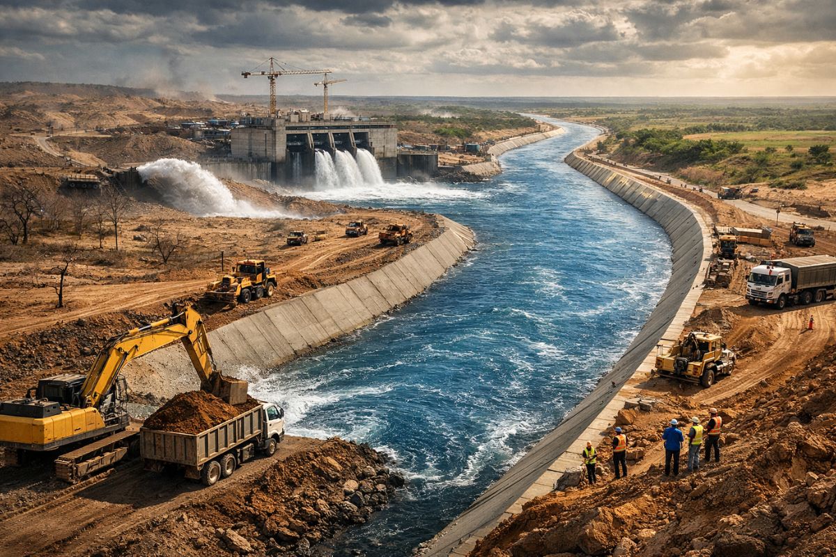
The River Designed by the Government of the State of Ceará Transforms Terrain into Infrastructure: By Capturing Water at the Jati Dam and Conducting it for 145.3 km to Nova Olinda, the State Integrates Transposition, Canals, Siphons, and Tunnels to Supply Vulnerable Areas, Alleviate Drought, and Strengthen Essential Reservoirs in the Ceará Semi-Arid from 2026.
In Ceará, the word river has ceased to represent only a natural watercourse and has become an engineering solution as well. Section 1 of the Ceará Water Belt, spanning 145.3 kilometers, was designed to gravity-feed water transposed from the São Francisco River from the Jati Dam to Nova Olinda.
The structure is entering a decisive phase with completion expected in 2026 and focuses on directly impacting the supply of regions plagued by recurring drought, such as Cariri and Alto Jaguaribe. By reinforcing strategic reservoirs, the system serves directly over 500,000 residents and can reach about 5 million people in Ceará.
How the Engineering River Works and Why It Reduces Energy Consumption

Although referred to as an “artificial river,” the Ceará Water Belt Project (CAC) is not a continuously flowing open river shaped by nature. It is an adduction system made up of open channels, siphons, and tunnels, designed to transport water with hydraulic control.
-
Denmark Constructs World’s Largest Immersed Tunnel to Connect with Germany, Sinking 217-Meter Concrete Sections in the Baltic Sea

-
Low-Cost Concrete Panel House Goes Viral: Investor Reveals Prefabricated Kit Structure for Around $1,500, Assembled in 30 Days, with Plans for Rental and Resale Income

-
Polymeric Mortar Revolutionizes Brazilian Construction with Efficient, Clean Application and Uniform Finish

-
Biologist Builds 160m² Dream Home in Brazil for $32,000 Using Eco-Friendly Bricks, Achieving 67% Savings Through Smart Planning and Simple Solutions


The central technical point is the utilization of the topography, which allows gravity flow for a large part of the route.
In practice, this design choice reduces the need for permanent pumping and thereby lowers operational energy costs.
In a region historically pressured by water scarcity, this efficiency is not a minor detail: it influences the long-term sustainability of the system, improves operational predictability, and strengthens the capability to maintain water supply even in critical periods.
Where It Starts, Where It Passes, and What Has Been Completed in the 145.3 km Section

The capture occurs at the Jati Dam, connected to the North Axis of the São Francisco River transposition. From this point, the water travels 145.3 km to cross the Cariús River in Nova Olinda. This hydraulic corridor reorganizes the circulation of water in the territory, directing flows to inland areas where irregular rain patterns hinder supply.
Section 1 had a total estimated investment of about R$ 2 billion and is divided into five execution lots. The main hydraulic sections of Lots 1, 2, and 5 have already been completed in a significant part of the project, totaling nearly 80 km of lined channels, siphons, and tunnels. Lots 3 and 4 are still ongoing, comprising the final stage for the full entry of the system into the projected schedule for 2026.
How Much the System Delivers: Flow, Reservoirs, and Social Reach in the Interior
With a maximum expected flow of 30 m³ per second, the system was designed to supply strategic reservoirs in Ceará, including the Orós Dam, the state’s second-largest, and the Castanhão Dam, the largest. This is not stagnant water in a canal, but a reinforcement to structures supporting supply networks and water security on various scales.
The anticipated social impact is broad: the project can reach about 5 million people in Ceará, with direct benefits for over 500,000 individuals and effects on 24 municipalities. This reach occurs because the project redistributes flows between basins, enhances local resilience, and strengthens adduction systems in areas where water supply is already operating at its limits.
Why the River in Ceará Became a Strategic Piece Against Prolonged Drought

In Cariri, where there is a high population density and economic relevance, the pressure on the Missão Velha aquifer has become a warning sign.
By bringing water from the São Francisco closer to the region, the project expands the supply for multiple uses and reduces dependence on an underground source under intense exploitation. It is a structural response, not an emergency one, to tackle recurring drought cycles.
In Alto Jaguaribe, integration with programs such as the Water Network tends to enhance the distribution of treated water to cities with high water vulnerability.
The logic is clear: to combine transport, storage, and distribution infrastructure to transform physical availability into real access. In the semi-arid region, this technical chain determines whether water arrives regularly or remains a promise.
What 2026 Represents for the Schedule and for the Routine of the Served Cities

If the execution schedule is maintained, 2026 marks the operational turning point of a project long awaited.
The effective entry of water into the hydraulic corridor changes reservoir management, urban supply planning, and decision-making in municipalities dealing with seasonal uncertainty. When water predictability increases, the impact is felt in daily life: schools, health units, commerce, and local production begin to operate with fewer interruptions.
It also changes the quality of public planning. Instead of acting solely in response to emergencies, municipalities and regional systems can work with a longer horizon, integration between basins, and technical prioritization of human consumption.
The expected result is not only more water circulating, but more stability for those living where drought has always dictated the rules.
Ceará is using engineering to create a new water pathway where nature alone could not ensure regularity.
With 145.3 km, flow of up to 30 m³/s, connection to the São Francisco and reinforcement of strategic reservoirs, the infrastructure river enters 2026 as a concrete bet to reduce water vulnerability in the interior.
To make construction feasible in such a challenging terrain, the execution of Section 1 was broken down into five distinct lots. Lots 1, 2, and 5 have already completed their hydraulic sections and this means that around 80 km of operational structures, including the complex systems of tunnels and channels, are ready to fulfill their purpose.
In your region, what makes the most difference when the drought tightens: large-scale projects, local distribution networks, reservoir management, or a combination of all these? And, looking at the semi-arid region, what should be the absolute priority of this river: immediate human consumption, protection of water sources, or a balance between supply and local development?


nao me importa os gatos o importante é pegar os ratos.
prioriza o consumo humano de forma a dar alívio ao morador que fixa na terra e produz riqueza em seguida o setor agroindustrial e depois os empresários da indústria e comércio o conjunto da obra traz a produção de riqueza e aumento de arrecadação às prefeituras estado e governo federal que se realizar a gestão certa fará história.
Sou aq. da margem do São Francisco. E uma boa agua para todos. M Caso vcs,terminem esse servico ai a marjem d Sao Francisco, vai secar.
Sou um pouco ignorante no assunto mais acredito recursos híbridos sempre se recuperam …. assim o Rio São Francisco nunca secará