
 Portuguese
  Spanish
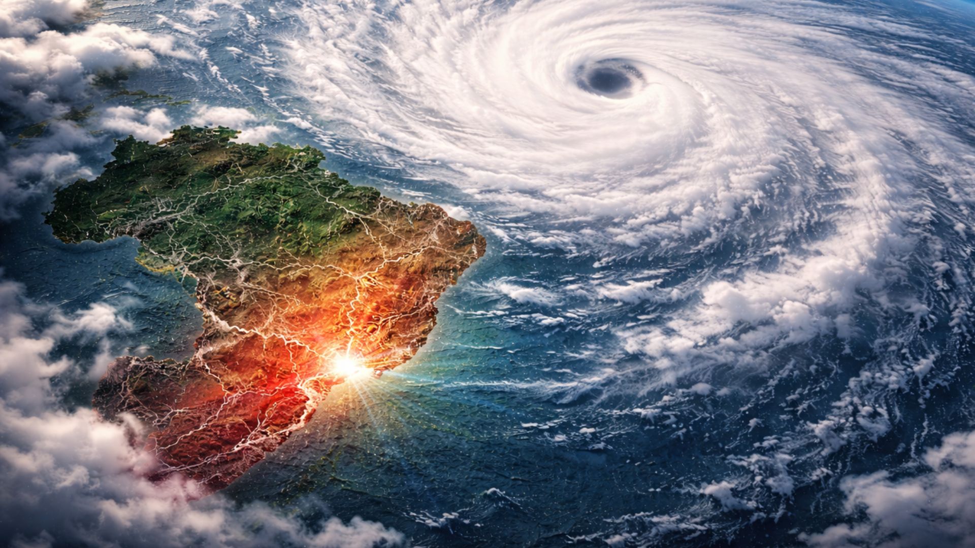
Distant phenomenon in the Pacific draws attention from Brazilian meteorologists as it emerges amid important changes in the ocean, indicating possible global climatic reorganization that may influence rainfall, temperatures, and extreme events in the country in the coming months.
In recent days, the advancement of super typhoon Sinlaku in the Western Pacific has stood out. This has raised a central question among meteorologists about why such a distant system has entered the Brazilian climate radar.
Although the cyclone does not pose any direct risk to national territory, its formation occurred in an oceanic and atmospheric environment that signals broader transformations underway in the Pacific, with the potential to alter climate patterns in various regions of the planet.
In this context, the system gained strength over exceptionally warm waters, in a strategic area for global climate balance, while international centers indicate that the Equatorial Pacific remains neutral, but with a consistent increase in the probability of developing El Niño in the coming months.
-
Humanoid Robot Climbs 6,263-Meter Volcano in Ecuador, Sets Sights on Everest Challenge

-
Physicist Harvests Water from Fog in the World’s Driest Desert, Turning Mountains into Water Traps

-
Wikipedia Blocks AI-Generated Edits, Citing Distrust in Automated Systems and Outlining Plans to Use Technology Without Losing Article Control
-
NASA Tests Rover with Lizard-Like Suspension and Independent Wheel Traction, Aiming for Speed Ten Times Faster than Perseverance on Mars


Therefore, Brazilian meteorologists are closely monitoring the phenomenon, as changes in the Pacific directly influence the distribution of rainfall and temperature in the country, especially during transition periods between phases of ENSO.
Warming of the Pacific and signs of climate change
Currently, data shows that the ocean exhibits clear signs of reorganization, with extensive areas recording above-average temperatures, especially in the Western Pacific, where accumulated heat acts as fuel for the intensification of tropical cyclones.
Thus, the rapid intensification of Sinlaku does not occur in isolation, but within a highly energetic environment, where the ocean provides enough heat to sustain intense systems in a short period of time.
At the same time, relevant changes in atmospheric circulation have been observed, with weakening of trade winds and occurrence of westerly gusts, factors that favor the movement of accumulated heat towards the center and east of the Pacific.
This movement occurs through Kelvin waves, which function as pulses of thermal energy in the ocean, contributing to modify the global climate pattern by transporting warmer waters to regions where cold waters normally prevail.
Still, the current stage remains under monitoring, as the presence of a super typhoon in this scenario reinforces a favorable environment, but does not solely define the formation of El Niño.
Impacts of El Niño on Brazil’s climate
The connection between the Pacific and Brazilian climate occurs through changes in global atmospheric circulation, which alter wind patterns, pressure, and the formation of weather systems over South America.
Historically, El Niño episodes are associated with increased rainfall in Southern Brazil, which can elevate the risk of floods and extreme events, depending on the intensity and duration of the phenomenon throughout the seasons.
Meanwhile, regions in the North and Northeast tend to experience drier periods, reflecting the displacement of areas of greater atmospheric instability to other parts of the continent.
In the Central-West and Southeast, the effects vary according to the time of year, potentially including more intense heat waves and irregular rainfall distribution.
Despite these trends, it is important to highlight that the impacts are not automatic or uniform, as each El Niño episode presents its own characteristics, influenced by additional factors such as Atlantic temperature.
Warm Water Pool and Accumulated Energy in the Ocean
Among the central elements of this scenario is the so-called “warm water pool” in the Western Pacific, located near Indonesia and Australia, where a large amount of thermal energy accumulates over the months.
During La Niña periods, stronger trade winds push even more warm water into this region, increasing the heat accumulation at the sea surface and strengthening this energy reservoir.
When these winds weaken, this heat begins to gradually shift towards the center and east of the Pacific, initiating a process considered essential for the development of El Niño.
In the current scenario, the presence of this heat reservoir sustains the increased likelihood of the phenomenon, while also creating favorable conditions for the formation of more intense tropical systems.
The formation of Sinlaku within this environment reinforces the understanding that the ocean is highly energetic, reflecting a significant transitional phase in the global climate system.
What Can Already Be Said About the Super Typhoon
In the specific case of Sinlaku, the system developed rapidly and reached great intensity due to the combination of elevated ocean heat and favorable atmospheric conditions in the Western Pacific.
This type of intensification is directly linked to the availability of thermal energy at the sea surface, an essential factor for the organization and strengthening of tropical cyclones.
On the other hand, the relationship between this event and El Niño needs to be analyzed with caution, as the climatic phenomenon depends on a set of indicators that evolve over time.
Among these factors are the ocean temperature in specific regions and the behavior of winds along the equatorial Pacific, elements continuously monitored by international meteorological centers.
In this sense, the increase in the probability of El Niño had already been indicated before the formation of the typhoon, which reinforces the interpretation that the cyclone is part of a broader scenario and does not act as an isolated cause.
Climate monitoring continues in the coming months
Over the next few weeks, the evolution of conditions in the Pacific will continue to be closely monitored by meteorological centers, which observe the persistence of warming in key areas of the ocean.
For an El Niño episode to be confirmed, it is necessary for this warming to be maintained for a continuous period, reaching specific criteria defined by international bodies.
Meanwhile, events like Sinlaku help illustrate the level of energy present in the current climate system, providing clues about the intensity of ongoing changes.
In Brazil, attention remains focused less on the path of the typhoon and more on the signals that the ocean has been emitting, which may anticipate relevant changes in rainfall and temperature behavior in the coming months.


Be the first to react!