
 Portuguese
  Spanish
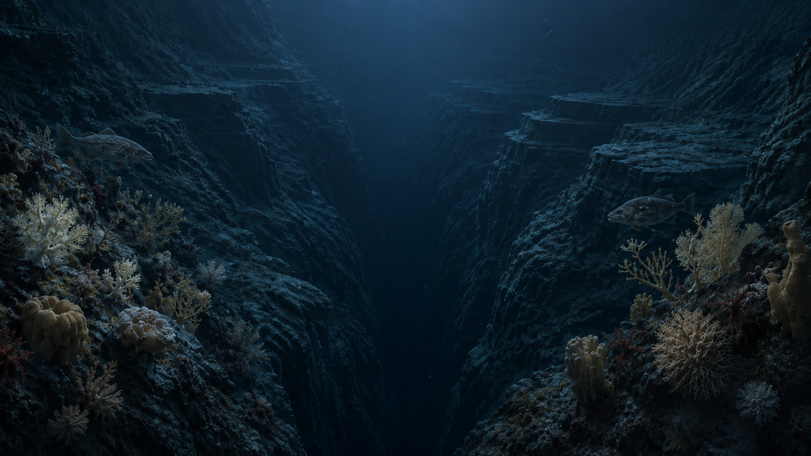
At 2,600 meters deep between Alaska and Siberia, the Zhemchug Canyon surpasses the Grand Canyon in vertical scale and reveals a rare submerged ecosystem in the Bering Sea
The Zhemchug Canyon, between Alaska and Siberia, plunges about 2,600 meters, surpasses the Grand Canyon vertically, and reveals one of the most extreme submerged landscapes on the planet.

The submarine rift that surpasses the Grand Canyon
The Zhemchug Canyon is named after a Russian word meaning “pearl.” The formation lies under turbulent waters, like a gigantic submarine rift.
Its absolute vertical depth reaches 2,600 meters, while the Grand Canyon, in Arizona, reaches 1,857 meters at its maximum depth.
-
Bosch Unveils Series 8 Dishwasher with Zeolith Drying, Voice Control, and Energy-Efficient Features

-
Brazilian Students Develop “Reminder Robot” to Help Seniors with Medication Management Using Arduino Technology

-
Canada Makes Historic Decision to Purchase New German Submarines in $70 Billion Defense Program, Replacing Aging Victoria-Class Fleet by 2033
-
4,000-Year-Old Stone Circle Discovered Near Belfast, Unveiling Prehistoric Ritual Complex in Irish Countryside


The comparison shows why the formation draws attention. Less visible than the United States tourist attraction, the Zhemchug Canyon surpasses the American gorge in vertical scale.
Besides the depth, the aquatic depression encompasses a total area of 11,350 km². The volume of icy water associated with the formation is estimated at approximately 5,800 km³.
The measurements that define the record of the submarine rift
The title of the largest in the world depends on different criteria, as other submarine valleys lead in specific categories. The Zhemchug Canyon stands out in the metrics of vertical depth and drainage area.
The Kroenke Canyon, in the Western Pacific, leads in linear extension, with about 700 km. Meanwhile, the Bering Canyon competes for leadership in total volume, with 4,300 km³ of water retention.
According to comparative data, the Zhemchug Canyon has a maximum depth of 2,600 meters and a linear length of 160 km. The Grand Canyon has a maximum depth of 1,857 meters and a length of 446 km.

How the Yukon River helped open the abyss
The origin of the fracture dates back to the last glacial period. At that time, the oceans were between 100 and 120 meters below the current level, exposing the continental shelf where the crack is located today.
With the area on dry land, the Yukon River flowed much more southwest than in its current regular course. This ancient path helped carve the base of the trench.
After the glaciation, the rise in sea level completely submerged the terrain. From then on, turbidity currents, loaded with sediments and rocks, began to scrape the walls and flatten the abrupt topography.
This continuous process shaped the depression. The millennial erosion, associated with the changing ocean levels, explains the deep landscape hidden under the Bering Sea.
Upwelling sustains life at the bottom of the sea
Despite the darkness and depth, the Zhemchug Canyon is not described as a lifeless desert. Its rugged topography creates a phenomenon known as upwelling, or deep upwelling.
This dynamic brings cold, mineral-rich water to the surface. The movement forms the Bering Sea Green Belt, associated with suspended nutrients.
The result is a large and complex ecosystem, with a three-dimensional habitat. Among the organisms mentioned are bioluminescent colonies of cold-water corals, installed on the rocky walls of the formation.
Also appearing are giant multicellular sponges, which filter strong deep ocean currents. The environment also hosts commercial fish species, such as Pacific cod, and abundant and reproductive populations of Pacific halibut.
Human exploration and maps of the hidden valley
The on-site exploration of this trench requires great technical capacity. In 2016, Alaska marine ecologist Michelle Ridgway single-handedly piloted a 2.4-meter submarine and reached a depth of 536 meters.
The dive occurred within the limit supported by the pressure hulls. The mission showed how direct access to the Zhemchug Canyon is restricted, risky, and dependent on equipment prepared for deep waters.
Researcher Dan O’Neill, from the Geophysical Institute at the University of Alaska, highlighted that the smooth surface of the water hides the real face of the submarine depression.
Therefore, the geography of the hidden valley takes shape through computerized bathymetric mappings. These surveys allow visualization of contours that do not appear to those who only observe the sea surface.
The submerged cracks remain among the most inhospitable and least understood territories. The evolution of high-frequency acoustic radars is expected to deliver, in the next decade, definitive three-dimensional maps of these areas.
The technical mastery of this cartographic information could redefine global strategies for the preservation of extreme marine biodiversity.
The protection of these trenches is also presented as essential to maintaining the biological balance of fishing and marine life.
With information from BMC News.


