
 Portuguese
  Spanish
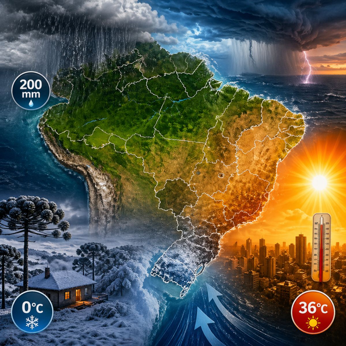
The last week of May brings Brazil a scenario of simultaneous climatic extremes: a polar air mass drops temperatures to 0°C in the Serra Gaúcha and the Southern Santa Catarina Plateau, while the Southeast records highs of 36°C with humidity below 30%. In the North and Northeast, the Intertropical Convergence Zone can cause rainfall of up to 200 mm with a risk of flooding in at least 11 states.
Brazil enters the last week of May facing temperatures ranging from 0 degrees in the South to 36 degrees in the Southeast, a thermal amplitude of continental proportions that illustrates the country’s climatic complexity. Responsible for the sharp drop in thermometers is a polar air mass that enters through Rio Grande do Sul on Sunday night (26) and pushes minimums to near or below zero in high-altitude areas between Monday (27) and Tuesday (28). The extratropical cyclone formed over the state drives the system and intensifies its effects throughout the Southern region.
While the South freezes, the Southeast bakes. Maximums can reach 36°C in several areas with relative humidity below 30%, a configuration that increases the risk of respiratory problems and dehydration. In the North and Northeast, the Intertropical Convergence Zone (ITCZ) causes intense rains with accumulations of up to 200 mm that threaten at least 11 states with floods, landslides, and road interruptions. Brazil will simultaneously experience three distinct climatic scenarios that require different alerts and precautions in each region.
Extreme cold in the South: where temperatures can reach zero
According to information released by the Ndmais portal, the polar air mass arriving in the South of Brazil is considered the most intense of 2026 so far. The effects begin to be felt between Monday and Tuesday, with the lowest temperatures occurring in the early mornings. Afternoons will also be cold, with the thermal sensation aggravated by the winds accompanying the system.
-
$7,999 Isaac 1 Robot Aims to Tackle Household Chaos: Folds Clothes, Makes Beds, and Organizes, but Raises Privacy and Cost Concerns with Camera Reliance and Remote Human Assistance

-
Mobile Electron Accelerator Units Enable Safe Testing of Water, Materials, and Industrial Waste Treatment in Countries Without Permanent Labs

-
Brazil Invests $12 Million in Biodiversity to Develop Drug Molecules, but When Will It Reduce Dependence on Imported Pharmaceutical Ingredients?
-
3D Printing: From 1945 Sci-Fi Concept to Modern-Day Prosthetics, Homes, and Industrial Parts


Climatempo’s projections detail the distribution of cold by altitude ranges. Campos de Cima da Serra, in Rio Grande do Sul, and the Southern Santa Catarina Plateau can record minimums between 0°C and 2°C. The border with Uruguay and plateau areas of Rio Grande do Sul should mark between 3°C and 5°C. The central region and the Gaúcho valleys will be between 5°C and 7°C, while the Metropolitan Region of Porto Alegre should oscillate between 8°C and 10°C. Frost is expected in several regions, with potential impact on cold-sensitive agricultural crops.
The 36-degree heat in the Southeast and the humidity that worries
While the South faces polar cold, the Southeast experiences the opposite scenario. Maximums of 36°C combined with relative humidity below 30% create conditions that the World Health Organization classifies as a state of alert, as they increase the risk of dehydration, irritation of the respiratory tract, and worsening of chronic diseases. The dry and hot weather is expected to persist in the coming days, with no immediate relief foreseen.
The thermal amplitude between the South and Southeast reaches 36 degrees on the same day, a distance that separates the freezing of mountainous areas from the intense heat of cities like Ribeirão Preto, Goiânia, and Belo Horizonte. This variation is not uncommon in continental Brazil, but the intensity of the two extremes occurring simultaneously highlights the vulnerability of regions that need completely different climatic responses in the same week. The frontal system that cools the South does not reach the Southeast with enough force to drop temperatures.
Rainfall of up to 200 mm in the North and Northeast
At the other end of the country, the ITCZ maintains intense activity and causes rains that can accumulate up to 200 mm throughout the week. The storms threaten at least 11 states: Acre, Amazonas, Roraima, Amapá, Pará, Tocantins, Maranhão, Piauí, Ceará, Rio Grande do Norte, and Paraíba. The volume of precipitation can cause urban flooding, river overflow, and road interruptions, especially in areas with deficient drainage infrastructure.
In the South, the extratropical cyclone also leaves its mark in the form of rain. Rio Grande do Sul and Paraná could record accumulations of up to 150 mm by Wednesday (29), with intense downpours also affecting Santa Catarina and Mato Grosso do Sul. The combination of heavy rain at the beginning of the week with polar cold in the following mornings creates a scenario of instability that requires extra attention from residents and civil defense authorities throughout the region.
The extratropical cyclone behind the extremes
The extratropical cyclone formed over Rio Grande do Sul this weekend is the engine connecting the week’s different phenomena. It pulls the polar air mass towards the continent, generates intense rain in the South region, and reinforces the frontal system that separates the cold of the South from the heat of the Southeast. Without the cyclone, the thermal amplitude would be smaller and the rains less concentrated.
The system is expected to move away from the continent at the beginning of the week, but its effects will persist for several days. The cold air mass driven by the cyclone keeps temperatures low until Wednesday in the South, while the instability associated with the frontal system causes precipitation that adds to the accumulations already predicted by the ITCZ in the North and Northeast. The result is a week in which practically all of Brazil faces some type of significant climatic event.
How to prepare for a week of climatic extremes
The diversity of scenarios requires different recommendations for each region. In the South, the priority is protection against the cold with adequate warm clothing, care for frost-sensitive agricultural crops, and attention to the elderly and homeless people who are most vulnerable to near-zero minimums. Heavy rain at the beginning of the week requires monitoring of risk areas and clearing of gutters and storm drains.
In the Southeast, constant hydration, avoiding sun exposure between 10 am and 4 pm, and using humidifiers are basic measures to cope with the dry heat. In the North and Northeast, the recommendation is to follow alerts from Inmet and Civil Defense, avoid crossing flooded areas, and have an evacuation plan for riverside areas that historically suffer from overflows. Brazil, with its continental dimensions, will experience in a single week what many countries do not experience in an entire season.
Are you in the cold South, the hot Southeast, or the rainy North? Tell us in the comments what the weather is like in your city and if you are prepared for the climatic extremes this week promises to bring.


