Portuguese
  Spanish


An archaeological discovery in northern China reveals how urban planning, defense, and underground engineering combined in a Neolithic city, expanding knowledge about societies that lived more than four millennia ago.
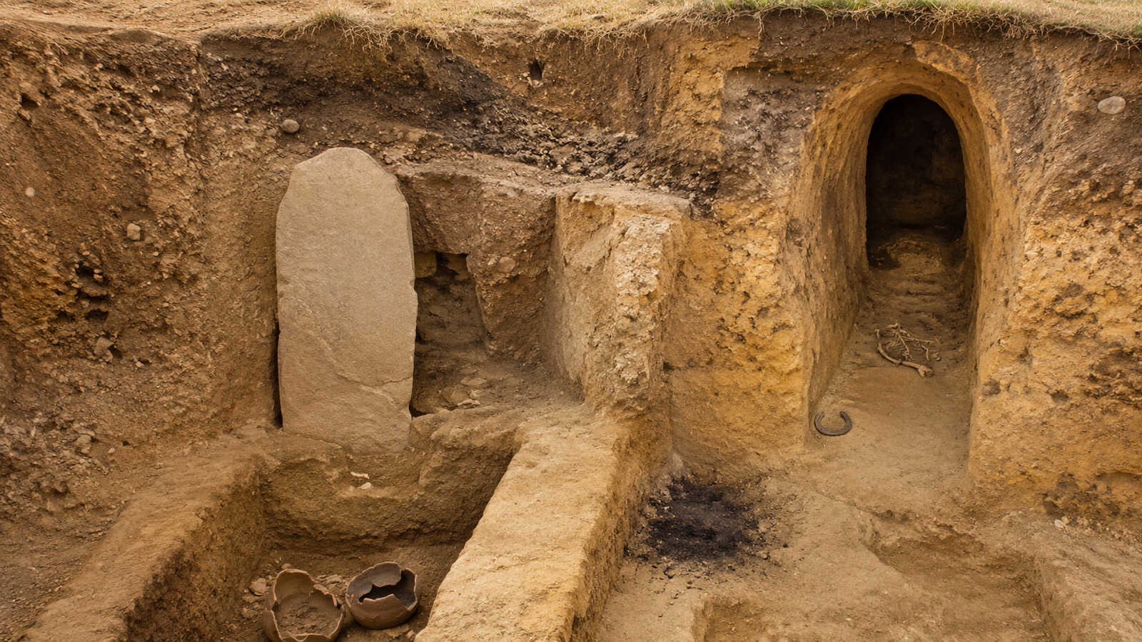
Archaeologists identified six underground passages beneath the ruins of Houchengzui, a stone city built about 4,200 to 4,500 years ago in northern China.
Distributed at up to 6 meters deep, the tunnels traverse fortified sectors and connect to areas located inside and outside the walls, forming part of a defensive system that occupied 138 hectares.
The site is located in Qingshuihe County, belonging to the city of Hohhot, in the Inner Mongolia Autonomous Region.
-
Scientists discover that the pressure between 2 and 6 kilometers deep in the ocean transforms “marine snow” into food, releasing up to 50% of the carbon and causing the amount of bacteria to grow 30 times in just two days.

-
Paraná was once the seabed 400 million years ago, and scientists from UEPG found a mollusk fossil never before recorded in Ponta Grossa, turning exposed rocks into evidence of ancient oceans that covered the region and still hide new marine species preserved for millions of years.

-
14.6-liter hydrogen engine surprises by delivering 600 horsepower, using more than 90% of the diesel engine structure, and still operating with less pure fuel, reducing changes in manufacturing and installation in heavy vehicles.
-
USA releases UFO photos taken during astronauts’ flight on the space shuttle Columbia, revealing a triangular object changing position over Earth and admitting that there is still not enough data to identify its origin.


Built on the northern bank of the Hun River, the ancient settlement featured walls, moats, gates, elevated platforms, and structures designed to control the entry and movement of people.
Systematic excavations began in 2019 and continued until 2023, under the responsibility of the Inner Mongolia Institute of Cultural Relics and Archaeology.
The work allowed for the reconstruction of part of the city’s organization and showed that the visible constructions on the surface were just one layer of a broader project.
Under the ground, researchers found corridors with arched ceilings, different depth levels, and paths that followed the layout of the fortifications.
The six tunnels were between 1.5 and 6 meters below the surface and were distributed radially from the central region of the settlement.
Underground tunnels expanded the city’s defense
The passages generally measured between 1 and 2 meters in height and about 1.5 meters in width, according to information released from the archaeological results.
Some larger sections, documented in the early stages of the research, reached 3.4 meters in width, 2.4 meters in internal height, and just over 6 meters in depth.
These differences indicate that the corridors did not follow a single pattern throughout their extent.
The width allowed for the movement of people, while the inclination of the entrances and the paths under the defensive structures made visualization from the surface difficult.
Archaeologists have not yet established a definitive function for each passage.
The position of the tunnels, however, supports the interpretation that they were part of the city’s circulation and protection system.
Part of the corridors could be used to move people, tools, or other materials without relying on the main gates.
Sun Jinsong, director of the Inner Mongolia Institute of Cultural Relics and Archaeology, explained that two of the initially located passages had different connections.
“One leads from the inner barbican outside the city and the other is connected to the moat,” the archaeologist told China Daily.
He emphasized that further studies would be needed to determine the exact use of the structures.
The discovery, therefore, does not prove that all tunnels were escape routes nor that they were built to face a specific enemy.
There is also not enough evidence to claim that they functioned exclusively as storage, trade routes, or military corridors.
Three lines of protection surrounded Houchengzui
The archaeological area is approximately 1,150 meters wide by 1,200 meters long.
Its shape took advantage of the terrain: the Hun River was to the south, while natural channels surrounded the east, west, and north sides.
The main land connection to the outside occurred through an elevated area to the northeast.
On this terrain, the builders erected three successive lines of defense.


The first included the main wall, the access gate, and lateral projections that allowed control of the approach.
The second comprised another wall, platforms, towers, and an internal moat.
Further on, a third barrier combined the outer wall, new platforms, and a moat linked to the natural formations of the region.
Among these elements were structures similar to barbicans, fortified spaces placed in front of the main accesses.
Anyone trying to enter would need to traverse narrow and controlled areas before reaching the urban core.
The tunnels added an underground dimension to the defensive planning.
Instead of relying solely on high walls and open moats, the inhabitants created routes that passed under strategic points and connected different sectors of the complex.
The set helps researchers study how communities at the end of the Neolithic period organized large works.
The construction required knowledge of the terrain, deep excavation, ceiling support, and coordination between the underground corridors and the surface buildings.
Technology helps to rebuild the stone city
In addition to manual excavation, the team employed remote sensing, geophysical surveys, terrain prospecting, and opening of selected areas.
The combination of these techniques allowed for the identification of traces without removing the entire layer of soil covering the site.
This type of investigation helps to recognize changes in the subsoil composition, locate buried structures, and define where an excavation should be conducted.
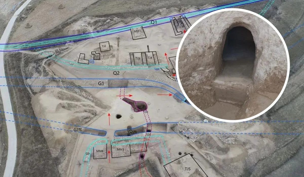
In Houchengzui, the data obtained were compared with walls, gates, moats, platforms, burials, and objects recovered during the fieldwork.
The research also revealed ceramics, jade pieces, stone tools, and objects made of bones.
These materials provide information about diet, agricultural production, animal husbandry, hunting, and cultural exchange among communities living in different areas of northern China.
According to the studies released by the team, the population primarily cultivated millet and combined agriculture with animal husbandry and hunting activities.
Bones of pigs, sheep, dogs, deer family animals, and other species were found at the site.
The architectural remains show similarities with elements observed in ancient cities like Shimao, in Shaanxi province, and Bicun, in Shanxi province.
Even so, researchers identified differences in the layout of the gates and the paths used to enter the fortified areas.
For Sun Jinsong, some features of Houchengzui’s accesses also resemble earth constructions that later emerged in the central Chinese plains.
According to the archaeologist, these correspondences constitute evidence of contact and circulation of techniques between populations from different regions.

Subterranean structure still holds questions
The ancient city is considered one of the largest and most fortified stone settlements of the Longshan period ever identified in Inner Mongolia.
The period corresponds to the final phase of the Neolithic in parts of China and precedes the consolidation of more complex political formations in the region.
Houchengzui was not only made up of walls.
Recent investigations have located an area interpreted by researchers as a sector of high-level constructions, with a gate, walls, platforms, house foundations, and other remnants.
A burial zone was also delineated.
These findings expand the study of the division of spaces within the settlement.
Residential areas, defensive structures, possible buildings of greater importance, and underground corridors seem to have been planned as related parts of the same occupation.
Despite the progress of the excavations, a conclusive explanation for the construction of the six tunnels has not been found.
Archaeology can document dimensions, paths, techniques, and connections, but the everyday function of each corridor depends on new evidence and comparisons.
It also remains unanswered whether the passages were opened during a single stage or expanded over time.
It is not known for certain how many people participated in the works, how long the construction took, or what tools were used in each section.
The underground network shows that the city’s planning reached spaces invisible to those approaching the walls.
After more than four millennia, excavations are still trying to determine how the residents used these corridors and why they invested so many resources in a structure hidden beneath one of the most protected cities of their period.