
 Portuguese
  Spanish
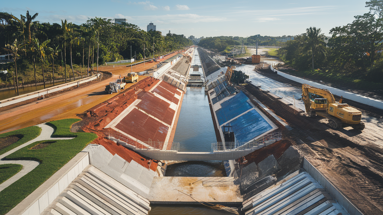

City Is Executing the Largest Flood Control Project in Its History. The Project Involves Restructuring Channels, Installing Gates, and Urban Renewal, Directly Impacting Neighborhoods Traditionally Affected by Rain.
Facing the relentless force of water has always been a challenge for many Brazilian cities.
In São Vicente, on the coast of São Paulo, residents of areas traditionally battered by floods can finally see a light at the end of the tunnel.
One of the largest infrastructure projects in the city’s history is underway, promising not only to minimize flooding but also to restore dignity to thousands of families.
-
Brazilian Joins Homeownership Consortium, Faces Decade of Dual Payments Totaling $141,000, Surpassing Traditional Mortgage

-
Land Rover to Halt Production in July, Putting 371 Jobs at Risk, as Chinese Automaker Negotiates to Convert Factory to 100,000 Vehicles Annually by 2027

-
Bolivian Female Construction Workers Form Association to Combat Discrimination and 38% Pay Gap in the Industry
-
Mexican Pest Threatens U.S. Cattle Herds at Historic Lows, Potentially Boosting Brazilian Beef Exports as Burger Prices Soar


Behind this grand project is a package of robust investments, which is already reshaping the urban landscape and bringing hope to the residents of São Vicente.

The Project That Promises to Change São Vicente
According to the newspaper Diário do Litoral, the works include the complete restructuring of a central channel and the installation of gates in eight strategic locations: Castelo Branco, Pompeba, Dique das Caixetas, Beira Jóquei, Sambaiatuba, Dique do Piçarro, Caminho da Divisa, and Sambaiatuba 2.
These actions aim to tackle the floods that frequently affect neighborhoods like Cidade Náutica, Vila Fátima, Pompeba, Jóquei, and Tancredo.
The channel, which is nearing completion, is one of the most complex parts of the project.
It is being significantly widened from six to ten meters in width and increasing its depth from 1.5 to 2.5 meters.
These improvements will be fundamental to cope with large volumes of water during periods of heavy rain or high tide.
According to experts, the project’s efficiency also depends on the installation of the gates, which are advancing at a rapid pace.
So far, work has been completed in Sambaiatuba, is underway in areas like Avenida Castelo Branco and Pompeba, and will still be implemented in areas like Caminho da Divisa.
Urban Transformation Beyond Drainage
In addition to combating floods, the initiative is promoting a complete urban renewal of the area surrounding the channel.
Streets like Stélio Machado Loureiro and Antero de Moura are receiving new micro-drainage interconnections, finishing work, paving, modernized sidewalks, and quality lighting.
These improvements not only provide protection against flooding but also enhance the value of the affected neighborhoods, making them more attractive for future investments and improving residents’ quality of life.
Who Is Behind the Work?
The project is being executed by the construction company DP Barros, under state supervision through the Department of Water and Electric Energy (Daee).
The resources come from a package of investments from the Government of the State of São Paulo, which allocated R$ 45 million to the municipality.
Of this total, R$ 30 million is exclusively allocated for the drainage system, reinforcing the commitment to natural disaster mitigation.

Benefits Beyond Fighting Floods
The positive impacts of this project go far beyond the obvious.
The reduction of flooding will allow local businesses and shops to operate more safely and predictably, avoiding losses caused by floods.
For resident families, the end of the flooding nightmare may represent a new beginning, with more safety, health, and quality of life.
Furthermore, large-scale projects also generate direct and indirect jobs, boosting the local economy and training workers from the region.
It is a clear example of how investments in infrastructure can transform not only the physical space but also the social and economic dynamics of a city.
An Example for Other Brazilian Cities?
Though grand, São Vicente’s project raises a debate about the infrastructure deficit in other Brazilian municipalities facing similar issues.
Should other cities adopt similar models to combat floods?
This project can serve as an example for regions suffering from the lack of adequate urban planning and public policies geared towards disaster prevention.
After all, a project like this not only solves historical problems but also brings long-term benefits to the population.
São Vicente on the Path to Transformation
With the works advancing rapidly, São Vicente is showing how investment in infrastructure can generate significant changes in a municipality.
The city’s largest flood control project is much more than an engineering work: it is a symbol of transformation, resilience, and hope.
It remains to be seen how these interventions will conclude and hope that the results meet expectations, ensuring a safer future for the residents of São Vicente.
And you, do you believe that works like these should be a priority in all Brazilian cities?


O Brasil tem uma montanha de despesas com a política e com políticos. Para que? Para que os mesmos detectem as fragilidades de seus estados e municípios para propor melhorias em todas as áreas, porém, muitos políticos só querem se locupletar e os problemas não são resolvidos, se perpetuam e quem sofre é exatamente o pagador de impostos que não enxerga o retorno de suas contribuições… Parabéns Tarcísio, no seu governo todos enxergam as melhorias e sua honradez.
Pode tentar o que quiserem, a água ninguém segura.
Tem que desapropriar as terras baixas que às águas pertencem .
Gostaria de saber de onde é essa foto que ilustra a matéria, ou se é vão uma montagem com IA, pois não conheço essa avenida, com essas proporções.