Portuguese
  Spanish
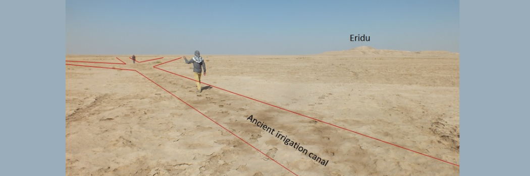
The Discovery of Mesopotamian Canals and Supervision Structures Reveals the Advances of Early Civilizations in Agriculture Development and Environmental Adaptation
An extensive network of ancient irrigation canals has been identified near the historic city of Eridu, located in southern Mesopotamia. The discovery occurred under the leadership of geoarchaeologist Jaafar Jotheri, with a team of researchers specializing in water management in the ancient world.
The study revealed an advanced irrigation system dating back to the first millennium BC. Researchers mapped and analyzed this underground network, providing new insights into the agricultural practices used in the region.
Technology and Mapping
Previously, knowledge about agricultural techniques in Mesopotamia was primarily based on cuneiform texts.
-
Brazilian Researcher Develops Protein Supplement from Tilapia Waste, Combining Innovation and Sustainability with Economic Potential

-
Women in São Paulo Unknowingly Tracked by Coin-Sized Tags Hidden in Cars and Belongings, Raising Stalking Concerns
-
Near a $750 million AI data center in Brazil, a resident’s well runs dry, leaving her unable to afford the $25,000 needed for repairs.

-
16-Year-Old from Brazil’s Sertão Wins Young Scientist Award for AI Predicting Rainfall with 94.5% Accuracy to Aid Farmers


The discovery of this network of canals provides concrete physical evidence of how ancient farmers used water from the Euphrates River for cultivation between the 6th century BC and the early first millennium BC.
The Eridu region remained virtually untouched for centuries. This is due to the alteration of the Euphrates River course around 1000 BC, which led to the abandonment of the area.
As a result, the irrigation network remained preserved, unlike other locations in Mesopotamia, where later constructions covered or destroyed similar structures.
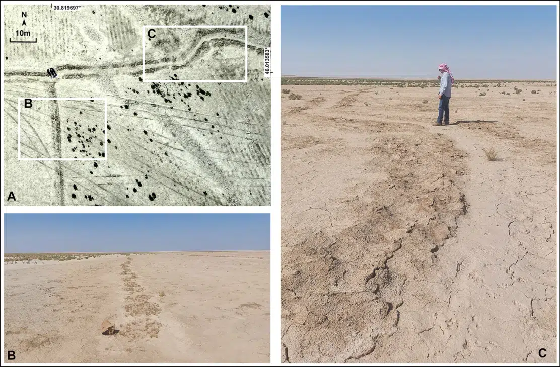
The researchers used satellite imagery, drones, and geological maps to analyze the landscape and reconstruct the flow of water.
The field study confirmed the existence of over 200 primary canals, directly linked to the ancient course of the Euphrates River. More than 4,000 secondary canals were also identified, supplying about 700 agricultural areas.
Antiquity .
Efficiency and Agricultural Adaptation
The discovery also reveals that early farmers used the natural topography to enhance irrigation efficiency. The raised riverbanks, natural formations along the Euphrates River, allowed water to flow by gravity to the fields. These structures facilitated water distribution while maintaining soil fertility.
Researchers highlighted that the breaches in the banks, known as breaks, helped direct water to more distant areas of the floodplain. This system sustained agriculture for centuries, allowing for the expansion of crops on both sides of the river.
However, the northern bank showed more intensive production due to better water distribution.
The study highlights the ability of the farmers of the time to plan and manage their environment strategically. The irrigation system was not fixed but underwent modifications according to agricultural needs and environmental changes.
New Research on Irrigation Canals
The research team plans to deepen the studies to determine the exact age of the canals and understand the changes in agricultural practices over time. Comparing the obtained data with descriptions in cuneiform texts may help reconstruct the history of water management in the region.
This discovery provides valuable evidence of the complexity of ancient civilizations and their ability to adapt to the environment.
With information from Interesting Engineering.