
 Portuguese
  Spanish
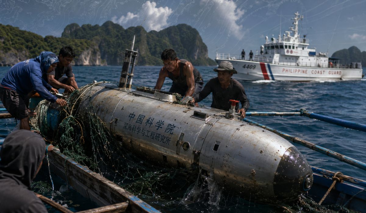
Found by fishermen in Palawan, a submarine drone with Chinese markings reignites doubts about oceanographic research, maritime security, and data collection in one of the most disputed areas of the South China Sea.
Filipino fishermen found on September 28, 2025, an autonomous underwater vehicle about 3.6 meters long in the waters of Linapacan, in the province of Palawan, in the western Philippines.
The equipment was handed over to the Philippine Coast Guard on the same day and began to be analyzed by technical teams, according to a statement from the Philippine Coast Guard released by the Philippine Information Agency.
The object had inscriptions in Chinese and sensors compatible with oceanographic measurements, according to the preliminary assessment by the Philippine authorities.
-
Alaska’s 1,287 km Pipeline Built on 78,000 Metal Supports to Prevent Thawing, Survives Earthquakes and Remote Forests, Highlighting the Challenge of Hot Oil in a Harsh Environment

-
Brazilian Student Innovates Sustainable Ceramic Tableware Using Rice Husks and Recycled Glass, Achieving Up to 60% Waste Composition and Comparable Performance to Conventional Materials
-
AI-generated fake doctors deceive elderly in Brazil, health videos go viral with nearly 300,000 views, turning disease fear into a global audience and money machine.

-
Innovative Thermal Battery in Brazil Can Store Renewable Energy for Weeks, Offering Cheap Electricity and Winter Heating


The Coast Guard reported that the case will be examined in coordination with national security agencies, because such equipment can collect physical data from the sea in areas considered sensitive.
Although autonomous underwater vehicles are used in scientific research, the presence of unauthorized equipment in a disputed region has begun to be treated by Manila as a maritime security issue.
The interpretation by the Philippine authorities is that the find adds to previous occurrences involving similar objects in different parts of the archipelago.
The device collected in Palawan was described as an AUV, the English acronym for autonomous underwater vehicle.
This type of vehicle can navigate below the surface without a crew, follow programmed routes, and record information about the marine environment.
According to the Philippine Coast Guard, the initial analysis identified a CTD sensor, an instrument used to measure conductivity, temperature, and depth.
The equipment also had an inscription in Chinese associated with a “seawater salinity sensor,” as well as a serial number and signs of corrosion.
Submarine drone found in the Philippines
In oceanography, salinity, temperature, and depth data help understand how water behaves in different layers of the ocean.
These measurements allow mapping currents, water masses, environmental variations, and physical changes that do not appear on the surface.
The Woods Hole Oceanographic Institution, an international reference in marine sciences, defines the CTD as a central tool for determining the physical properties of seawater.
The instrument records information used to calculate temperature, salinity, and density along the water column.
In areas of maritime dispute, these same data can also have military applications, according to experts in underwater acoustics.
Temperature, salinity, and pressure influence the speed and propagation of sound in water, relevant factors for navigation, detection, and submarine operations.
This relationship explains why seemingly scientific equipment attracts the attention of naval authorities.
In submarine operations, knowing the physical conditions of the sea can help interpret acoustic signals, plan movements, and reduce uncertainties in routes below the surface.
The Philippine Coast Guard stated that previously recovered units had the capability to process, store, and transmit data autonomously.
In one of the cases, according to the agency, encrypted communications with mainland China were identified during the operation.
South China Sea and the Dispute for Submarine Data
The Palawan drone was not presented by the Philippine authorities as an isolated incident.
According to the Coast Guard, at least five drones of Chinese origin were recovered between July 2022 and December 2024 in different areas of the Philippines, as reported by spokesperson Jay Tarriela to USNI News.
Among the locations mentioned are areas near Misamis Oriental, Masbate, and the Luzon Strait, a strategic maritime passage between Taiwan and the northern Philippines.
The Philippine Navy had already displayed some of this equipment in April 2025 and attributed to them possible use in mapping Philippine waters.
The Coast Guard also mentioned technical evidence found in previous recoveries, such as Chinese SIM cards, satellite transmitters, and components linked to companies based in China.
These elements still require case-by-case analysis, but they help explain why Manila treats the findings as part of possible unauthorized activity in its waters.
Admiral Ronnie Gil Gavan, commander of the Philippine Coast Guard, stated that the action of the fishermen was important for the object to be reported to the authorities.
According to him, the episode shows the need to keep the coastal population alert to unauthorized activities at sea.
In remote areas, fishermen may be the first to locate unusual objects, such as buoys, sensors, drones, and metal pieces.
When these items are collected and delivered to official agencies, they can provide information about routes, origin of components, technical capacity, and potential data collection.
Palawan and Maritime Tension in the Pacific
Palawan is facing the South China Sea, a region marked by territorial disputes and the presence of military, fishing, and research vessels.
The area encompasses trade routes, fishing zones, potential energy reserves, and corridors used in civil and military navigation.
China claims a large part of the South China Sea through a line on its maps known internationally as the “nine-dash line” or, in more recent versions, the “ten-dash line.”
This claim overlaps with areas also claimed or patrolled by Southeast Asian countries, including the Philippines, Vietnam, Malaysia, and Brunei.
In 2016, an arbitral tribunal constituted under the United Nations Convention on the Law of the Sea concluded, in a case brought by the Philippines, that there was no legal basis for Chinese historical rights over maritime areas within the so-called “nine-dash line” when these rights exceeded the limits provided by the Convention.
China rejected the arbitration and did not participate in the process.
The UN Convention on the Law of the Sea also establishes that marine scientific research in the exclusive economic zone and continental shelf of a coastal State must occur with the consent of that State.
This point is used by Manila to contest unauthorized research activities in areas under its maritime jurisdiction.
How an underwater drone collects information
Autonomous underwater vehicles have recognized uses in marine science and technology.
They can map the seabed, measure currents, monitor ecosystems, investigate shipwrecks, and collect data in locations where manned ships have limited access.
The context in which these devices operate, however, alters the way data is interpreted.
In a region with territorial disputes and military presence, information about depth, temperature, salinity, and underwater relief can be of interest to both researchers and naval forces.
Analyst Rocio Gatdula, a defense economy specialist based in Washington, told USNI News that Chinese objectives may include the mapping of the Philippine underwater topography to support naval and submarine operations, as well as the collection of data with military, navigational, and resource value.
The Philippine Coast Guard reported that the equipment found in Palawan will undergo technical and forensic examinations to determine origin, operational characteristics, and potential risks.
Until the analysis is concluded, public identification is based on markings, sensors, and similarity to previously recovered devices.
The technology behind ocean sensors
The technology involved in this type of case does not always have a sophisticated appearance.
An underwater drone may have a shape similar to that of an elongated metal tube, with sensors and external parts that do not immediately indicate the amount of data the equipment can store.
Even so, each measurement can have technical utility.
Conductivity allows for estimating salinity.
Pressure helps calculate depth.
Temperature reveals thermal layers.
Combined, this information forms a physical profile of the ocean and helps understand how the water varies from one region to another.
Experts in underwater acoustics point out that this type of profile also aids in the study of sound propagation below the surface.
As acoustic signals are essential for navigation and detection systems at sea, environmental data can be relevant in naval operations.
The Palawan case shows how research equipment can gain different significance when appearing in disputed areas.
For scientists, the sensors help describe the ocean.
For governments, the same collection can raise questions about authorization, purpose, and control of sensitive information.
The Philippine investigation has not yet publicly concluded the operational history of the drone retrieved by the fishermen.
Even so, the episode reinforced the debate about the presence of unmanned vehicles in strategic waters and the difficulty of monitoring activities that occur far from the surface.


