Portuguese
  Spanish


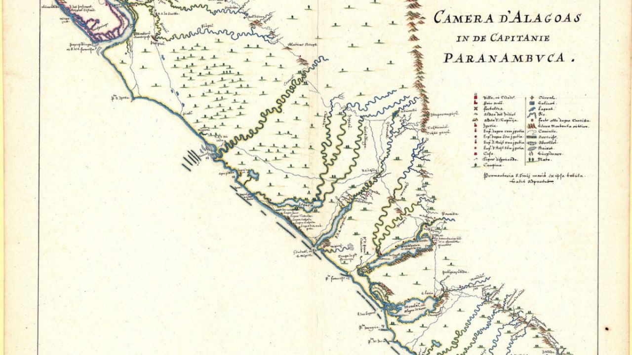


Discovery of Unpublished Map May Reveal the Location of Ancient Quilombos Linked to Palmares in Pernambuco and Alagoas, Opening New Avenues for Archaeological Research and Preservation of Black Memory.
Brazilian researchers are working with an unpublished map that may indicate the location of the oldest quilombos associated with the legendary Quilombo dos Palmares in the Northeast of the country.
The document, a handwritten version of the map Brasilia Qua Parte Paret Belgis, produced in 1647 and found in the collection of Harvard University in the United States, will be used to guide archaeological excavations starting in January 2026.
The discovery involves archaeologists, historians, and cartographers from federal universities, funded by the Palmares Cultural Foundation and authorized by the National Institute of Historical and Artistic Heritage (Iphan).
-
Engineers Develop Fridge-Sized Machine to Produce 95-Octane Synthetic Fuel from Air and Water, Aiming to Sustain Combustion Engines Without Oil

-
Two-Armed Robot Uses AI to Reassemble Destroyed Pompeii Frescoes, Solving an “Impossible” Puzzle
-
New Law in Brazil Requires Breaks for Type 1 Diabetes Management at Work, School, and Public Exams

-
Scientists Confirm “Greening” of Antarctica: Ice on the World’s Coldest Continent Turns Green as Mosses Multiply Over Tenfold in Four Decades


The goal is to locate and study remnants of the communities where escaped enslaved people organized during the colonial era.
The initiative opens unprecedented opportunities to understand how the first quilombos operated even before the consolidation of the great Quilombo dos Palmares in Serra da Barriga, Alagoas.
By cross-referencing the map with historical accounts and modern technologies, such as satellite images, the team hopes to confirm where these communities were established in the 17th century.
Historical Map Reveals Paths of Resistance of the Quilombos
The unpublished map identified segments of the Dutch occupation in Northeast Brazil and was essential for reconstructing the routes of expeditions against quilombos in the 17th century.
It is part of a cartographic work produced by George Marcgraf and published by Johan Blaer.
The handwritten version found by researchers, however, contains details that helped fill gaps left by printed reproductions over the centuries.
By overlaying the old map onto high-resolution satellite images and modern geographical references, scholars were able to identify possible locations of three quilombos described in accounts from the time.
The combined analysis of the cartographies and historical documents was crucial for estimating more accurately where these communities were located.
Where Could the First Quilombos Be?
According to the reconstructions, two of these quilombos would be in the current municipalities of Correntes and Lagoa do Ouro, in the Agreste region of Pernambuco.
A third would be situated between Chã Preta and União dos Palmares, in the Alagoas region.
These areas were mentioned in accounts by the Dutch commander Johan Blaer, who led expeditions against quilombola communities in 1645.
While the first of these locations appears abandoned in the overseas documents—possibly due to unhealthy conditions—the second was also left by its inhabitants after confrontations.
However, the third is believed to have remained active until later, underscoring its importance in the history of the quilombos in the region.
Archaeological Research Starts in 2026
With the planning complete, the multidisciplinary team will begin excavations in January 2026.
The project brings together archaeologists from the Federal University of Alagoas (UFAL – Sertão Campus), geographers, historians, and anthropologists, as well as the historical cartographer responsible for the discovery of the map.
The fieldwork will include surface surveys, the use of drones, and metal detectors to locate artifacts and buried structures.
The researchers aim to find remnants that reveal aspects of daily life in quilombola communities, such as ceramics, utensils, iron artifacts, and even traces of constructions.
The new methodological approach, which combines historical documents with modern mapping and satellite technology, could transform the narrative about the quilombos in Brazil.


The study is also part of a larger effort to preserve and recognize Black memory in the country, in line with contemporary initiatives that seek to value the culture and history of quilombola populations.
With information from Diário de Pernambuco.