Portuguese
  Spanish
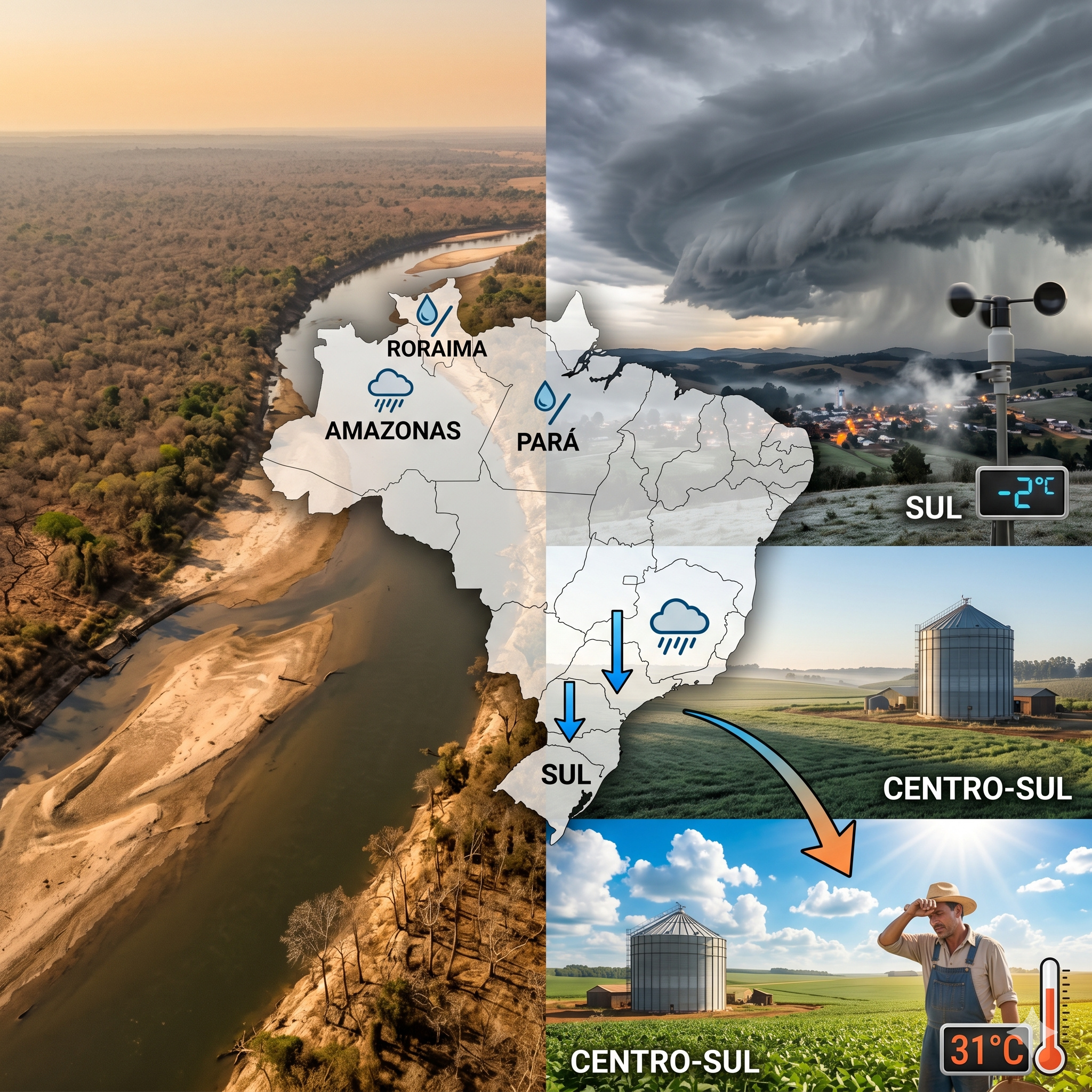
INMET and Climatempo indicate May 2026 with drought in the North, cold fronts in the South, and atmospheric blocking in the Central-West.
According to INMET, Weekly Meteorological Bulletin nº 17/2026, published on April 27, indicates the highest accumulated rainfall for the first week of May in areas of the North and Northeast regions, while the entire central region of the country shows a predominance of dry and stable weather. Climatempo’s monthly forecast confirms this pattern, with below-normal rainfall in Pará, Roraima, most of Amazonas, northern Rondônia and Mato Grosso, and central-western Tocantins.
These are precisely the states that, in January and February 2026, received above-average rainfall, but are now entering the transition period to the dry season with an accumulated water deficit. Climate models already identify this scenario as a precursor to conditions that could make the second-half drought more severe than El Niño alone would justify.
Meanwhile, the South faces a sequence of weekly cold fronts, with above-average rainfall and temperature drops. What makes May 2026 technically exceptional is that these two opposing patterns occur simultaneously, sustained by the same high-pressure system that blocks cold fronts in the Central-West and keeps the Intertropical Convergence Zone compressed over the North.
-
OnePlus N6 Smartphone to Launch in India with 8,000mAh Battery and 45W SuperVOOC Charging, Lasting Up to Three Days

-
Scientists Plan to Release Air Bubbles Underwater to Protect Antarctica’s “Doomsday Glacier” from Melting

-
Chinese R6000 Drone Combines Airplane and Helicopter Features, Carries Up to 12 People for Multiple Missions
-
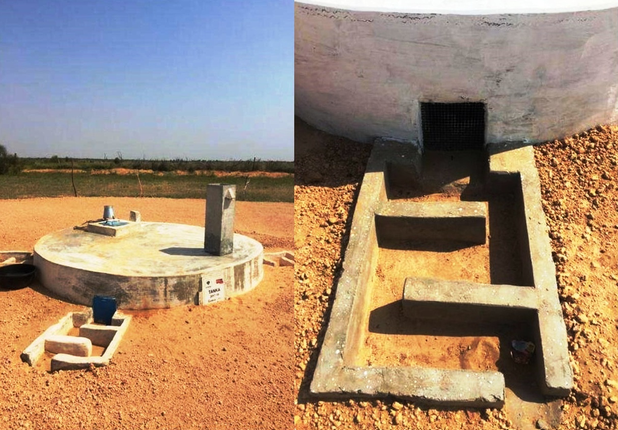
In the World’s Most Densely Populated Desert, Families Dig Funnel-Shaped Underground Cisterns to Capture Rare Rainfall and Store Drinking Water for Up to Eight Months


Why the North receives less rain in May and why the 2026 transition worries meteorologists
May is, by definition, the transition month from the rainy season to the dry season in Northern Brazil. The Amazon has two clear seasonal regimes: the rainy period, from November to April, when the Intertropical Convergence Zone migrates to the southern hemisphere and organizes bands of convective clouds over the basin, and the dry period, from May to October, when the ITCZ migrates north and precipitation drastically reduces in much of the region.
The ITCZ is the convergence zone of the trade winds from both hemispheres near the Equator. When positioned south of the Equator, during the austral summer, it organizes enormous rain systems over northern South America.

When it migrates north, during the austral winter, the rain cover retracts to the northern portion of the Amazon basin and the coast of Amapá, while the interior of Amazonas, Pará, and Roraima begins to dry.
What makes May 2026 technically different is not the seasonal migration itself, which occurs every year, but the speed with which the rain pattern is retracting over a basin that has not yet fully recovered its water levels after the extreme drought of 2023. The Rio Negro, in Manaus, reached its lowest level since records began in 1902, at 12.70 meters, in October 2023, below the alert level of 13 meters.
The Amazon enters the dry season with soils, vegetation, and aquifers still stressed by recent droughts
The 2024 flood was intense, with the Rio Negro rising above 29 meters in Manaus, but the drought in the second half of that year was severe again. In 2025 and 2026, the flood was more moderate in some sub-basins, which reduces the capacity for water replenishment before the start of the new dry season.
In practice, this means that subsurface aquifers, soils, and vegetation in parts of the Amazon arrive at the beginning of the 2026 dry season with less accumulated moisture reserve than the historical average. This condition makes the forest and rivers more vulnerable if the second half is reinforced by El Niño.
The problem is not just the amount of rain in May. It’s the starting point of the dry season. When the dry season begins over a system that is already partially deficient, any additional reduction in precipitation can produce faster and more severe effects on rivers, vegetation, and the risk of wildfires.
The precipitation anomaly map shows below-average rainfall over more than 3 million square kilometers
Climatempo’s precipitation anomaly map for May 2026 clearly shows the country’s division. The brown tones, indicating below-average rainfall, cover Pará, Roraima, most of Amazonas, northern Rondônia and Mato Grosso, and central-western Tocantins.
These states, together, cover more than 3 million square kilometers, an area larger than Argentina. In the first week of May, the INMET forecast indicates accumulations that could exceed 100 millimeters in seven days only in areas near the Negro and Amazon rivers, in a strip extending from western Amazonas to the Pará territory.

In other areas of the North region, rain is expected to occur irregularly, with volumes below 50 millimeters, a fraction of what is expected for the period in historical climatology. The precipitations are associated with the end of the rainy season and the residual activity of the ITCZ, which still maintains activity over the far north before migrating completely to the northern hemisphere.
Tocantins, southeast of Pará, and transition areas between the Amazon and Cerrado enter the dry pattern earlier
In the week of May 5 to 12, the dry pattern consolidates in strategic areas. Models indicate volumes between 20 and 40 millimeters for the border between Amazonas, Acre, and Rondônia, while in Tocantins and southeastern Pará, rainfall should not exceed 10 millimeters in seven days.
Tocantins and southeastern Pará are precisely in the transition region between the Amazon and Cerrado. These are areas that first enter the dry season and suffer the most when this period is intensified by the warming of the Pacific, the retraction of the ITCZ, and the atmospheric blocking in Central Brazil.
This anticipation of the dry pattern is concerning because the region functions as a climatic corridor between forest, savanna, and agricultural frontier. When this strip loses moisture too early, the risks increase for smaller rivers, pastures, crops, wildfires, and the transport of moisture to other regions of the country.
While the North dries, the South receives a sequence of cold fronts, storms, and above-average rain
While the North enters the dry season, the South faces a sequence of cold fronts that bring rain and a drop in temperature. This contrast is normal for May, but in 2026 it is being amplified by the high-pressure atmospheric blocking, which prevents these fronts from consistently advancing to the Southeast and Midwest.

In the week of April 27 to May 4, INMET forecasts the possibility of severe weather in the South, with storms, intense rain, wind gusts, lightning, and hail. In Rio Grande do Sul and Santa Catarina, accumulations could reach 80 millimeters in seven days, a volume higher than São Paulo’s monthly average of 66.3 millimeters.
In Paraná, the predicted volumes should not exceed 70 millimeters, but they may be concentrated in storm episodes with gales and hail.
The South should have at least one rain episode per week, and some of them may bring high volumes, contributing to a month above climatology in much of Rio Grande do Sul and Santa Catarina.
High-pressure blocking in the Midwest prevents the advance of cold fronts and amplifies the country’s climatic division
The high-pressure blocking in the Midwest is the direct mechanism that amplifies the asymmetry between the South, North, and Central Brazil. South America is surrounded by warm waters: the Pacific, from Ecuador to part of the Chilean coast, shows above-normal temperatures, while the Atlantic off the coast of Brazil is also warmer than average.
This configuration of warm oceans around the continent facilitates the formation and maintenance of high atmospheric pressure over Brazil. The anticyclone hinders the passage of cold fronts from the South to the Southeast and Midwest, keeping the cold air more concentrated in the far south and the heat more persistent in the interior of the country.
Several cold fronts are expected to pass through Rio Grande do Sul and Santa Catarina, but few will have the strength to reach São Paulo, Espírito Santo, or Goiás. The result is a divided country: the South receives rain and cold air incursions, while the Midwest and part of the Southeast remain under blocking, heat, and dry weather.
The second half of autumn should concentrate the strongest temperature drops in the Central-South
Climatempo projects that the second half of autumn, from mid to late May, and the beginning of winter, from June to early July, should concentrate the most significant temperature drops of the year in the Center-South. The pattern includes São Paulo, Minas Gerais, Rio de Janeiro, and all states in the South.
São Paulo may register lows near 10°C in the capital and between 0°C and 5°C inland during the most intense cold waves of this period. The mechanism that allows these cold air incursions, even in a year when El Niño begins to form, is the Antarctic Oscillation.
The AAO is forecast to be neutral with a negative bias in the coming weeks, which tends to favor precipitating systems and cold fronts in Southern Brazil. When the AAO is in a negative phase, the Antarctic circumpolar winds weaken, allowing polar air to advance more easily to lower latitudes.
Southern Agriculture Faces Short Window Between Favorable Cold, Regular Rain, and Risk of Excess in Spring
Southern agriculture is directly affected by this sequence. The second-crop soybeans being harvested in March and April in Paraná were harmed by excessive rain associated with the arrival of the first cold fronts after the La Niña period.
Wheat and barley, which begin to be planted in May, need mild temperatures and regular rain. These conditions should exist in the South during the second half of autumn and the beginning of winter, favoring the initial establishment of crops.
The window, however, is short. If El Niño consolidates with strong intensity in the second half of the year, excessive rain in spring could precisely harm the winter crops that May and June helped establish. The same pattern that favors planting can become a risk in the subsequent phase of the agricultural cycle.